Monthly Archives: March 2014

Deadmans Island

Feature type: island
Province: British Columbia
Location: Fraser River downstream from Tête Jaune

In September 1911, as construction of the railroad’s tote road approached Tête Jaune Cache, two young American adventurers, A. C. Jennison and D.C. Adams, freighted a canoe through the Yellowhead Pass to Resplendent. They canoed down the Fraser River until they reached the box canyon above Tête Jaune Cache, where their canoe capsized in an eddy and they both drowned. Weeks later their bodies were found, one of them at the point of this island a few miles below the Cache.

References:

  • MacGregor, James Grierson, 1905-1989. Overland by the Yellowhead. Saskatoon: Western Producer, 1974

Dawson Road

British Columbia. Road
Intersects Highway 16 E of Dunster
Roads are not in the official geographical names databases

Herbert C. (1892–1958) and Ethel G. (1896–1981) Dawson moved to a homestead between Dunster and Shere in the 1930s, after a spell of dry years in Saskatchewan. Herb worked on the railroad, homesteaded, and farmed. They raised six children, their youngest born at Lucerne (CNoR railway point) in 1924. During the 1930s Dawson took his team and wagon to Small Creek to work on the new highway being built from Tête Jaune Cache to Lamming Mills.

References:

  • Valemount Historic Society. Yellowhead Pass and its People. Valemount, B.C.: 1984
  • McBride Cemetary. Grave markers. 2000 Roots and Dirt. Roots and Dirt

Dawson Creek

British Columbia. Creek: Columbia River drainage
Flows W into Canoe Reach of Kinbasket Lake
52.2669 N 118.4944 W — Map 083D07 — GoogleGeoHack
Earliest known reference to this name is 1895
Name officially adopted in 1974
Official in BCCanada
Dawson in 1885

Dawson in 1885
Wikipedia

Adopted in 1954 on Columbia River Basin manuscript 75 as labelled on 1895 map of British Columbia; not “Boulder Creek” as labelled on 1911 map of Kootenay District, flowing into Canoe River.

Coordinates of mouth altered and description changed in 1974, following creation of reservoir behind Mica Dam; now flows west into Canoe Reach, Kinbasket Lake.

Presumably refers to George Mercer Dawson [1849–1901], given the early use of the name.

Dawson was a Canadian geologist and surveyor who performed many early explorations in western North America and compiled numerous records of the native peoples, including the Shuswap who were inhabitants of this area.

The Kamloops Indians affirm, that the very highest mountain they know is on the north side of the valley at Tête Jaune Câche, about ten miles from the valley. This is named Yuh-hai-has’-kun, from the appearance of a spiral road running up it. No one has ever been known to reach the top, though a former chief of Tsuk-tsuk-kwälk’, on the North Thompson, was near the top once when hunting goats. When he realized how high he had climbed he became frightened and returned.

Notes on the Shuswap People of British Columbia, 1891

Dawson was director of the Geological Survey of Canada from 1895 until his death in 1901.

References:

  • Tolmie, William Fraser [1812–1886], and Dawson, George Mercer [1849–1901]. Comparative Vocabularies of the Indian Tribes of British Columbia, with a Map Illustrating Distribution. Ottawa: Geological and Natural History Survey of Canada, 1884. Toronto Public Library
  • Dawson, George Mercer [1849–1901]. “Notes on the Shuswap people of British Columbia.” Transactions of the Royal Society Canada, Section 2 (1891). University of British Columbia
  • McConnell, Richard George [1857–1942], and Dawson, George Mercer [1849–1901]. Report on an exploration of the Finlay and Omenica rivers. Ottawa: Geological Survey of Canada, 1896. University of British Columbia Library
  • British Columbia Geographical Names. Dawson Creek

Davison Creek

British Columbia. Unofficial name: Fraser River drainage
Flows into Fraser near Croydon
53.0667 N 119.7167 W GoogleGeoHack
Not currently an official name.

Location approximate.

Leander (died 1925) and Edith (died 1924) Davison and four children moved to North Croydon in 1923. Leander grew up in Nova Scotia, and homesteaded in Alberta after 1900. He married Edith in 1910. When they moved to Croydon, they brought farm machinery, horses, and a cow down the river on a scow. The year after their arrival Edith died during childbirth. Newborn Archie was raised by Elizabeth and Tom McCallum. The next summer Leander died after a fall on a pitchfork. The other four children were raised by Edith’s parents, the Watsons, in Croydon.

References:

  • Haralson, Doris Neely. Northland Echoes. Yarrow, B.C.: Published by the author, Box 31, 1981
  • Valemount Historic Society. Yellowhead Pass and its People. Valemount, B.C.: 1984

David Glacier

British Columbia. Glacier: Fraser River drainage
Premier Range
52.7417 N 119.7667 W — Map 83D/12 — GoogleGeoHack
Earliest known reference to this name is 1925
Name officially adopted in 1962
Official in BCCanada
This glacier appears on:
W. A. D. Munday’s map Cariboos 1925

Named in 1924 by climbing party of Allen Carpé [1894–1932] and Rollin Thomas Chamberlin [1881–1948], in association with the nearby mountain and pass that they proposed be named Mount David Thompson and David Pass, in the mistaken belief that the pass was the true source of the North Thompson River.

References:

  • Carpé, Allen [1894–1932]. “Climbs in Cariboo Mts. and Northern Gold Range, Interior Ranges of British Columbia.” Alpine Journal, Vol. 37 (1925):63
  • Munday, Walter Alfred Don [1890–1950]. “In the Cariboo Range – Mt. David Thompson.” Canadian Alpine Journal, Vol. 15 (1925):130-136

Dave Henry Creek

British Columbia. Creek: Columbia River drainage
Flows SE into Canoe River, SW of Valemount
52.7444 N 119.0972 W — Map 83D/11 — GoogleGeoHack
Earliest known reference to this name is 1913
Name officially adopted in 1934
Official in BCCanada
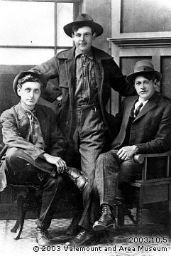
Everett Bogardus, Phil Estwein and Dave Henry, about 1914

Everett Bogardus, Phil Estwein and Dave Henry, about 1914
Valemount and Area Museum

Dave Henry first visited the Valemount area before 1910. “He and Fulton McKirdy came up the Canoe Valley in a scow from Revelstoke as far as they could,” said Mike Frye, whose family accompanied Henry to the area from North Dakota in 1911. Henry was “one of the best liked in the district, a real story teller,” according to another early settler. He was nicknamed “the Grizzly” because of his hair.

Henry opened the first store at Swift Creek (later named Valemount) in 1912. He is listed as storekeeper in the 1937 Valemount voters’ list, and as a cook in the 1943 Valemount post office directory. He was trail cook for the Hargreaves brothers’ hunting parties for many years, and also trapped in the area. Henry moved to Kamloops in the early 1950s, and from there to a Vernon nursing home. He died in the early 1960s.

Origin notes from BC Geographical Names: Davehenry Creek adopted 12 June 1934, not Avalanche Creek as labelled on Dominion Sectional sheet 262, Yellowhead, 1916, nor Cache Creek as labelled on BC map 3H, 1919. Davehenry Creek confirmed 17 January 1951 on Jasper Park (North). Form of name changed to Dave Henry Creek 8 July 1953 on Columbia River Basin manuscript 79: “flows SW into Canoe River…” (file C.1.53). Location description and coordinates of mouth adjusted 11 March 1974 on 83 D/11, because of flooding of McNaughton (now Kinbasket) Lake.

References:

  • Robson Valley Courier. Weekly newspaper published by Pyramid Press of Jasper from 1968–88 (1968–1988).
  • Valemount Historic Society. Yellowhead Pass and its People. Valemount, B.C.: 1984
  • British Columbia Geographical Names. Dave Henry Creek
Daam Road

Feature type: road
Province: British Columbia
Location: Forks S off Hwy 16 W of Horsey Creek

Dutch-born I. D. (Dik) (born 1912) and Louisa (born 1920) Daam retired to the Dunster area in 1970.

References:

  • Personal correspondence.

Cushing Creek

British Columbia. Creek: Fraser River drainage
Flows N into Morkill River E of Mount Bagg
53.6714 N 120.3644 W — Map 093H09 — GoogleGeoHack
Name officially adopted in 1925
Official in BCCanada

Adopted in 1925 and so-labelled on Boundary Commission Sheet 36, published in 1925 from surveys of 1923.

Nearby triangulation station “Cushing” is labelled on the 1925 sheet, although it had been identified as “Swanson” on preliminary maps and in the report of the Alberta-British Columbia Boundary Commission (Vol III, p.50). Apparently the creek had been tentatively labelled “Swanson Creek” on preliminary sheet #36 (Ottawa file OBF 0897).

Named after A. B. Cushing, holder of timber licenses along the creek and a large lumber retailer in Calgary. (A. B. Cushing Mills, established 1911, is still in operation.)

References:

  • Cautley, Richard William [1873–1953], and Wheeler, Arthur Oliver [1860–1945]. Report of the Commission Appointed to Delimit the Boundary between the Provinces of Alberta and British Columbia. Parts IIIA & IIIB, 1918 to 1924. From Yellowhead Pass Northerly. Ottawa: Office of the Surveyor General, 1925. Whyte Museum
  • British Columbia Geographical Names. Cushing Creek

Curve Creek

British Columbia. Creek: Fraser River drainage
Flows SW into Fraser between McBride and Legrand
53.3717 N 120.3039 W — Map 093H08 — GoogleGeoHack
Name officially adopted in 1965
Official in BCCanada
This creek appears on:
Pre-emptor’s map Tête Jaune 3H 1919 [Curve Cr. (Coyote)]
Pre-emptor’s map Tête Jaune 3H 1923 [Curve Cr. (Coyote)]

“Curve (Coyote) Creek” labelled on BC map 3H, 1915. “Curve Creek (not Coyote Creek)” identified in the 1930 BC Gazetteer.

References:

Also see: