Columbia River and Fraser River and Peace River drainages
W side of Rocky Mountains, from Montana to the Liard Plateau
54.5 N 122.5 W — Map 093J07 — Google — GeoHack
Name officially adopted in 1950
Official in BC – Canada
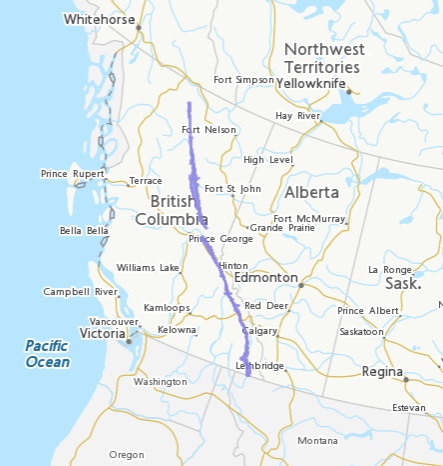
Although some of its topography has been carved into U-shaped glacial valleys, it is primarily a byproduct of geologic faulting. The Trench separates the Rocky Mountains on its east from the Columbia Mountains and the Cassiar Mountains on its west. It also skirts part of the McGregor Plateau area of the Nechako Plateau sub-area of the Interior Plateau of British Columbia.
The Trench is drained by four major river basins: the Columbia, Fraser, Peace and Liard. Two reservoirs of the Columbia River Treaty fill much of its length today – Lake Koocanusa and Kinbasket Lake. Rivers that follow the Trench, at least in part, are the Kootenay River, the Columbia River, the Canoe River, the Flathead River, the Fraser River, the Parsnip River, the Finlay River, the Fox River, and the Kechika River. The Fox, Parsnip and Finlay Rivers are part of the Peace River system. The Canoe River is a short tributary of the Columbia system, draining into Kinbasket Lake, a reservoir on the Columbia River.
- Wikipedia. Rocky Mountain Trench