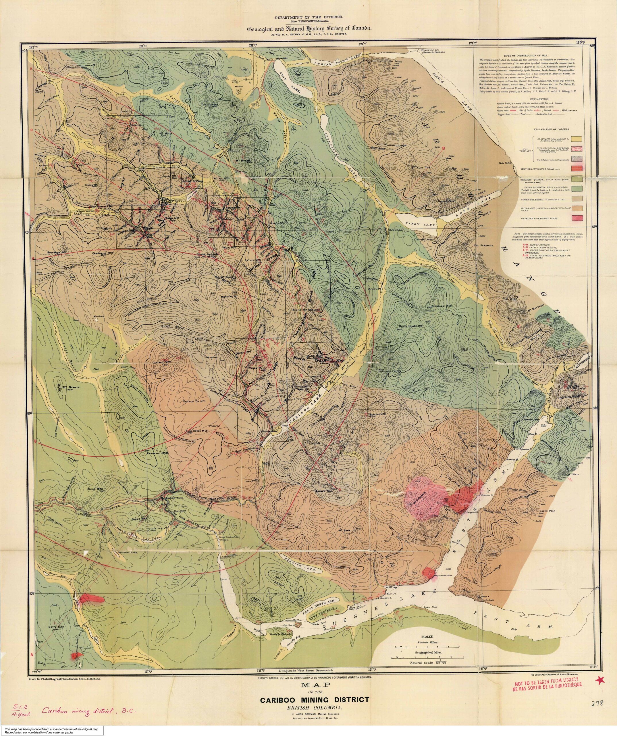
Map of the Cariboo Mining District to illustrate the report of Amos Bowman
Cariboo Gold Rush
In 1885 and 1886 Mr. Amos Bowman was engaged in geologically examining the Cariboo mining district of British Columbia, the expense of the undertaking being borne jointly by the Geological Survey of Canada and the Government of British Columbia. Mr. Bowman was assisted by Mr. James McEvoy, and for a part of the time by Messrs. S. P. Tuck and L. R. Voligny. The year 1885 was necessarily given chiefly to geographical and topographical work, but in the following year Mr. Bowman devoted most of his own time to the geological and mining features. His general report was published by the Geological Survey in the volume for 1887-88, together with a geological map of the district on a scale of two miles to an inch, and maps on a large scale of Hixon Creek and Island Mountain and Mosquito Creek.
It was intended to follow the report above mentioned by a second, in which detailed descriptions should be given of the principal auriferous creeks of the district. Maps of these creeks were prepared by Mr. Bowman and lithographed, but as he had in the meantime been obliged to sever his regular connection with the Survey in favour of urgent private business, the final correction and printing of these maps was only completed after long delays, and in June, 1894, Mr. Bowman died, without having written any descriptive matter to accompany these mining maps.
— George M. Dawson, Geological Survey of Canada, April, 1895
Amos B. Bowman was born at Blair, Ontario, but soon after, his parents moved to Ohio. Later he had a very distinguished career as a renowned scientist in Canada and the United States. Following university studies in Germany, he graduated as a civil and mining engineer, and traveled in Europe writing articles for the New York Tribune. An outstanding authority on geology, he had charge of a five-year California geological survey. He then joined an official Canadian geological survey, surveying the Cariboo mining region, and prepared reports on many sections of British Columbia.
Mr. Bowman promoted the interests of Fidalgo Island in British Columbia, whose possibilities impressed him. In recognition of his services, the town of Anacortes was named after his wife, Anna Curtis Bowman. He published a newspaper, and gave liberally in land to induce the building of a railroad up the Skagit Valley. It was said of this outstanding scientist that “he often impoverished himself to enrich others.”
Cariboo Mountains
- Bowman, Amos B. [1839–1894]. Map of the Cariboo Mining District, British Columbia, to illustrate the report of Amos Bowman. 1895. Cariboo Gold Rush
- Bowman, Amos B. [1839–1894]. Maps of the principal auriferous creeks in the Cariboo mining district, British Columbia. Ottawa: Geological Survey of Canada, 1895. Hathi Trust
- Dawson, George Mercer, D.S. [1849–1901]. Report on the area of the Kamloops map-sheet British Columbia. Ottawa: Geological Survey of Canada, 1895. Canadiana