British Columbia. Mountain
Headwaters of Geikie Creek
52.6833 N 118.35 W — Map 83D/9 — Google — GeoHack — Bivouac
Earliest known reference to this name is 1921
Name officially adopted in 1951
Official in BC – Canada
Elevation: 3103 m
Headwaters of Geikie Creek
52.6833 N 118.35 W — Map 83D/9 — Google — GeoHack — Bivouac
Earliest known reference to this name is 1921
Name officially adopted in 1951
Official in BC – Canada
Elevation: 3103 m
This mountain appears on:
Boundary Commission Sheet 28 (surveyed in 1921)
Boundary Commission Sheet 28 (surveyed in 1921)
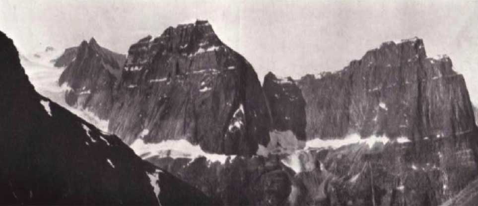
Mt. Casemate (left) and Mt. Postern (right) looking across the Geikie Valley from Drawbridge
Cyril G. Wates, 1926
Canadian Alpine Journal 1927
Adopted 17 January 1951 on Jasper Park (north) map, as labelled on BC-Alberta Boundary sheet 28, 1921. The feature was named by the Alberta-British Columbia Boundary Commission.
In fortifications, a casemate is a vaulted chamber build in the ramparts of a fortress, with openings for defensive fire.
References:
- Cautley, Richard William [1873–1953], and Wheeler, Arthur Oliver [1860–1945]. Report of the Commission appointed to delimit the boundary between the Provinces of Alberta and British Columbia. Part II. 1917 to 1921. From Kicking Horse Pass to Yellowhead Pass.. Ottawa: Office of the Surveyor General, 1924. Whyte Museum
- Cautley, Richard William [1873–1953], and Wheeler, Arthur Oliver [1860–1945]. Report of the Commission Appointed to Delimit the Boundary between the Provinces of Alberta and British Columbia. Parts IIIA & IIIB, 1918 to 1924. From Yellowhead Pass Northerly. Ottawa: Office of the Surveyor General, 1925. Whyte Museum
- Wates, Cyril G. [1883–1946], and Gibson, E. Rex [1892–1957]. “The Ramparts in 1927.” Canadian Alpine Journal, Vol. 16 (1927):85-95
- British Columbia Geographical Names. Casemate Mountain