Athabasca River and Columbia River drainages
Headwaters of Pacific Creek and Whirlpool River
52.3917 N 118.175 W — Map 83D/8 — Google — GeoHack
Earliest known reference to this name is 1824 (Simpson)
Name officially adopted in 1930
Official in BC – Topo map from Canadian Geographical Names
John Arrowsmith’s map BC 1859
Milton and Cheadle’s map 1865
Trutch’s map of BC 1871
Schäffer map of visits in 1907 and 1908
Boundary Commission Sheet 27 (surveyed in 1920 & 1921)
Boundary Commission Sheet 27 A (surveyed in 1921)
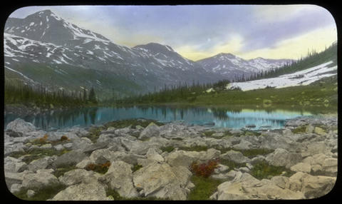
Committee’s Punch-bowl at the Source of the Whirlpool River. Hand-coloured lantern slide by Mary T.S. Schäffer. Photo taken in 1908
Archives Canada
At the very top of the pass or height of Land is a small circular Lake or Basin of water which empties itself in opposite directions and may be said to be the source of the Columbia and Athabasca Rivers as it bestows its favors on both these prodigious Streams. That this basin should send its Waters to each side of the Continent and give birth to two of the principal rivers in North America is no less strange than true both the Dr. & myself having examined the currents flowing from it East and West and the circumstance appearing remarkable I thought it should be honored by a distinguishing title and it was forthwith named the “Committee’s Punch Bowl.”
The Doctor was John McLoughlin [1784–1857]. The Committee was the executive of the Hudson’s Bay Company.
Fur trader Alexander Ross [1783–1856], who was travelling with Simpson’s party, published this account in 1825:
On the top of this height was six inches of newly-fallen snow, and a small circular pond of water about twenty feet in diameter. This height I named after our Governor, Mount Simpson ; and the basin of water on its top, the Governor’s Punch Bowl. No elevated height in this country can present a more interesting prospect than that viewed from the top of Mount Simpson: to the west, in particular, it is of a highly picturesque character.
Fur traders paused at this natural campsite to drink a toast “to their Honours the Governors,” the governing committee of the Hudson’s Bay Company in London.
The Athabasca Pass forms the watershed between the two great river systems of the Athabasca and the Columbia, whose waters flow out at either end (a somewhat rare and remarkable phenomenon) of a small mountain tarn rejoicing in the name of “The Committee’s Punch-Bowl.” West and east of the tarn, forming the Titanic pillars of this natural gateway to the north, were said to be the two great peaks, Mount Brown and Mount Hooker.
— Stutfield 1903
A lake with this “rare and remarkable phenomenon” is called a bifurcation lake.
- Simpson, George [1792–1860], and Merk, Frederick [1887–1977], editor. Fur trade and empire. George Simpson’s journal entitled Remarks connected with fur trade in consequence of a voyage from York Factory to Fort George and back to York Factory 1824-25. Cambridge, Mass.: Harvard University Press, 1931. University of British Columbia Library
- Ross, Alexander [1783–1856]. Fur Hunters of the Far West. A Narrative of Adventures in the Oregon and Rocky Mountains. Vol II. London: Smith, Elder and Co., 1855. Internet Archive
- Stutfield, Hugh Edward Millington [1858–1929], and Collie, John Norman [1859–1942]. Climbs and Explorations in the Canadian Rockies. London: Longmans, Green, 1903. University of British Columbia Library
- Schäffer Warren, Mary T. S. [1861–1939]. Old Indian trails. Incidents of camp and trail life, covering two years’ exploration through the Rocky Mountains of Canada. [1907 and 1908]. New York: Putnam, 1911. Internet Archive