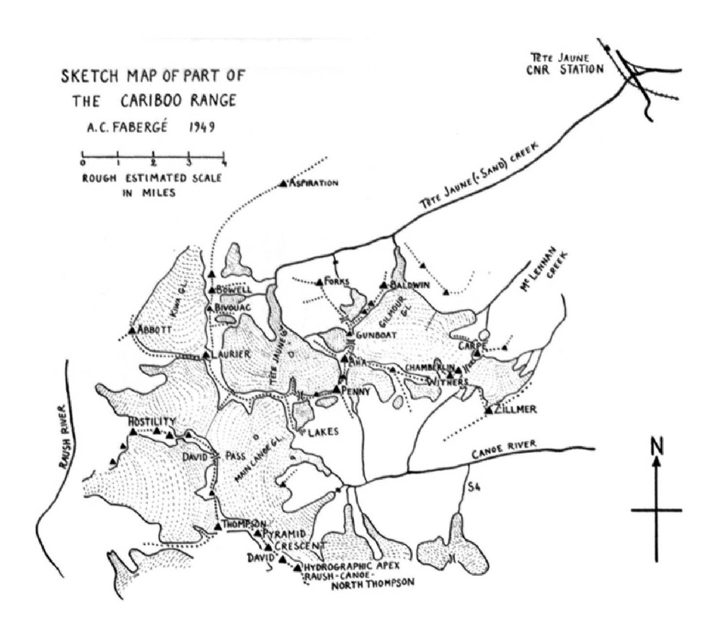
Sketch map of part of the Cariboo Range
A. C. Fabergé 1949
Canadian Alpine Journal 1950
By A. C. Fabergé, 1949
The central Cariboos are a region of high peaks, big glaciers and vast snowfields. Little can be seen from the valleys, and to appreciate the charm of these mountains one must go high. There, one is in a world of severe black cliffs set among the wonderfully precise curved surfaces of snow formations, of rock peaks with ridges sharply outlined by fantastic cornices. It is hoped that Arnold Wexler’s article in this issue and the map may encourage others to visit this region. The map is based on prismatic compass bearings from a number of vantage points, and on measurements of photographs. It is in every sense a cooperative effort, and several members of the 1949 party contributed to it. It is strictly confined to what we actually saw, and should be consulted together with Zillmer’s map (C.A.J., XXXI, 1948, p. 24) which covers more territory. To avoid overloading the map, the names of peaks have been abbreviated, thus Laurier-Mt. Sir Wilfred Laurier, etc. It may here be noted that Holway’s Penny and Aha are in all probability identical with the unnamed points 10,075 and 10,225 respectively, of Carpé, mentioned on page 151 of the 2nd edition of Thorington’s Guide to the Interior Ranges of British Columbia.
Some of our observations on passes may be of use to future climbers. The Tête-Forks basin pass is easy on both sides. The west side of Gunboat (Tête-Gilmour) Pass deserves a word of caution: there are some very large and almost impassable crevasses in the middle of the glacier. One may either go to the Tête-Forks Pass and thence follow Gunboat Ridge (or better the level glacial shelf on its west) or, alternatively, up the true left side of the glacier close to Aha Mountain.
The Tête Jaune-Canoe Pass marked on the map is the most convenient passage between the two valleys; it was also used by Zillmer in 1947, and is easily identified on the north side difficulties in crossing the by pass and the small spur jutting into the Tête Jaune Glacier immediately west of the pass. There are no difficulties in crossing the pass and in reaching the small glacial lakes. The main Canoe icefall cannot be tackled directly, and a band a of cliffs extends far down the true left side of this glacier. We found a convenient passage through these cliffs. Just south of the lakes there is a characteristic knoll covered with heather and dwarf spruce; if one descends immediately to the left of this knoll, keeping as close as possible to its steep sides, one is brought to a grass band which crosses the cliff and gives access to the lower Canoe Glacier. We did not go down to the Rausch, but we are almost certain that the glacier between Hostility and Sir Wilfred Laurier provides a convenient way, the icefall being by-passed along the slopes of Sir John Abbott.
David Pass is easy and needs no comment. The Chamberlin-Carpé Pass, apparently the only high level passage to the McLennan III basin, involves steep snow and a bergschrund which might under some conditions give trouble.
- Thorington, James Monroe [1895–1989]. A Climber’s Guide to the Interior Ranges of British Columbia. New York: American Alpine Club, 1937
- Wexler, Arnold. “Ascents in the Cariboo Mountains.” Canadian Alpine Journal, Vol. 27 (1950):41-50. Alpine Club of Canada
- Fabergé, A. C. “A sketch map of the Cariboo Range.” Canadian Alpine Journal, Vol. 27 (1950):119. Alpine Club of Canada