Fraser River and Mackenzie River drainages
Between Jarvis Creek and Hanington Creek
54.0906 N 120.1583 W — Map 93I/1 — Google — GeoHack
Earliest known reference to this name is 1915
Name officially adopted in 1982
Official in BC – Canada
Samuel Prescott Fay map Mount Alexander 1915
Boundary Commission Sheet 39 (surveyed in 1924)
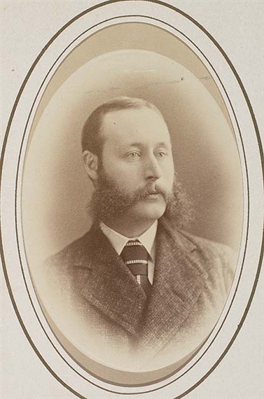
E. W. Jarvis — Christmas, 1872
The name was adopted by the Geographic Board of Canada in 1917 in recognition of surveyor Edward Worrell Jarvis [1846–1894].
“E.W. Jarvis, CE, and Major C. F. Hanington of Ottawa made an adventurous winter journey across the Rockies in 1875. The pass through which they crossed the mountains was named Jarvis Pass by the Geographic Board of Canada and the name Jarvis is also borne by a mountain on the south side of the pass opposite Mount Hanington. The exploration was undertaken to see if this route across the mountains would be a practicable one for the Canadian Pacific Railway. The elevation of the pass, about 5,000 feet, proved too high. The starting point of the journey was Quesnel, which was left on December 9, 1874, and a 1,000-mile journey, mostly on foot, occupying five and a half months, was concluded at Winnipeg on May 21, 1875.” (extract from Natural Resources Canada, Ottawa, June 1927)
- Hanington, Charles Francis [1848–1930]. Journal of Mr. C.F. Hanington from Quesnelle through the Rocky Mountains, during the winter of 1874-5. 1875. Internet Archive
- McBride, Sam. “Edward Worrell Jarvis in Western Canada.” Manitoba History, Number 78 (Summer 2015). Manitoba Historical Society
- British Columbia Geographical Names. Jarvis Pass