Alberta-BC boundary. Mount
N of Shale Pass, S of Morkill Pass
53.6167 N 119.7167 W — Map 83E/12 — Google — GeoHack
Earliest known reference to this name is 1923
Name officially adopted in 1925
Official in BC – Canada
N of Shale Pass, S of Morkill Pass
53.6167 N 119.7167 W — Map 83E/12 — Google — GeoHack
Earliest known reference to this name is 1923
Name officially adopted in 1925
Official in BC – Canada
This mount appears on:
Boundary Commission Sheet 37 (surveyed in 1923 & 1924)
Boundary Commission Sheet 37 (surveyed in 1923 & 1924)
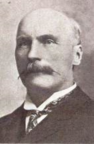
Peter Talbot. Appointed to the Senate of Canada in 1906, served during the premierships of Wilfred Laurier and Robert Borden until he died in 1919
Wikipedia
The mountain was named by the Geodetic Survey in 1923, during the survey of the interprovincial boundary, after Hon. Peter Talbot [1854-1919], Lacombe; Member of Senate of Canada, 1906-19.
(Not named after British travel author Frederick Arthur Ambrose Talbot [1880–1924], who traversed the Yellowhead Pass in 1910, one year ahead of the construction of the Grand Trunk Pacific Railway.)
References:
- Cautley, Richard William [1873–1953], and Wheeler, Arthur Oliver [1860–1945]. Report of the Commission Appointed to Delimit the Boundary between the Provinces of Alberta and British Columbia. Parts IIIA & IIIB, 1918 to 1924. From Yellowhead Pass Northerly. Ottawa: Office of the Surveyor General, 1925. Whyte Museum
- Canadian Board on Geographical Names. Place-names of Alberta. Published for the Geographic Board by the Department of the Interior. Ottawa: Department of the Interior, 1928. Hathi Trust
Also see: