Moose River, SE of Moose Lake
52.9167 N 118.8 W — Map 83D/15 — Google — GeoHack
Earliest known reference to this name is 1910 (Talbot)
Name officially adopted in 1951
Official in BC – Canada
Wheeler’s map Mount Robson 1912
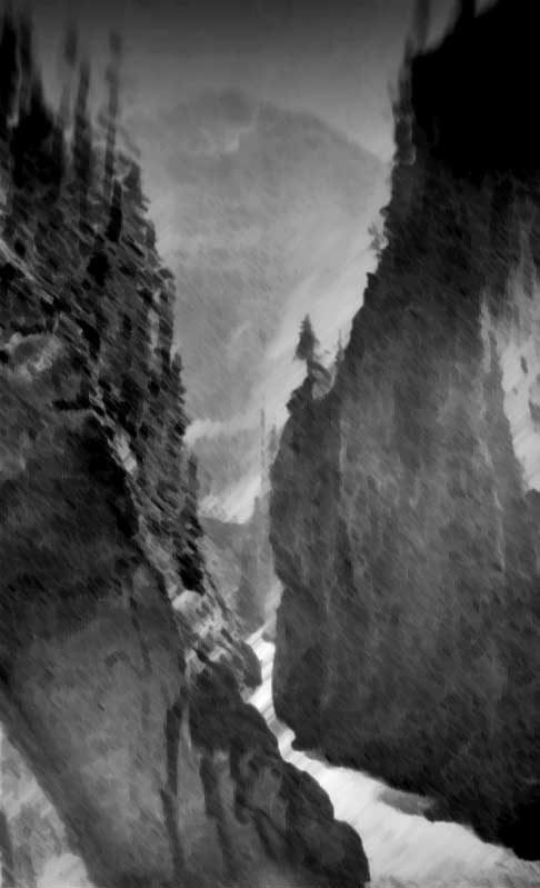
Rainbow Canyon.
Photo: Byron Harmon, 1911
Canadian Alpine Journal 1912
Arthur Oliver Wheeler [1860–1945], who headed the 1911 Alpine Club of Canada–Smithsonian Robson Expedition, wrote:
”Moose River emerges from a canyon directly beside the railway. It is very fine and will be a most attractive feature to the travelling public. The canyon is not more than two hundred yards in length and about 150 feet deep. There are two falls near the head, of which the upper drops 50 feet and the lower 20 feet. Here the grandeur and awe of the spectacle culminates; the gorge is at its wildest, the sheer rock walls at their steepest; you are between the two falls; flying mist and spray fill the available space and eddy and circle continuously. On sunny days baby rainbows play hide and seek. I counted, at one and the same time, half a dozen at various points of view. The name Rainbow Falls and Canyon is suggested as attractive and appropriate; the more so that the mountain group, of which Robson is the dominating mass, is known as the Rainbow Mountains. The canyon is an exceptionally fine study of the action and effect of a powerful glacial torrent.”
- Talbot, Frederick Arthur Ambrose [1880–1924]. The new garden of Canada. By pack-horse and canoe through undeveloped new British Columbia. London: Cassell, 1911. Internet Archive
- Wheeler, Arthur Oliver [1860–1945]. “The Alpine Club of Canada’s expedition to Jasper Park, Yellowhead Pass and Mount Robson region, 1911.” Canadian Alpine Journal, Vol. 4 (1912):9-80