Near Tête Jaune Cache on the Fraser River
52.9818 N 119.5151 W Google — GeoHack
Not currently an official name.
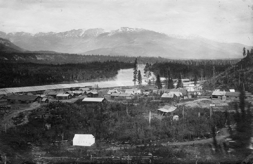
Mile 53 from the north-west, at the backwater SS Operator can be seen on the river
Valemount & Area Museum
James Alexander Walker surveyed the area in 1914:
From Mile 53 — this mileage is reckoned from the Summit at Yellowhead Pass along the railway — the [Fraser] river is navigable in high water as far as Soda Creek, a distance of nearly 500 miles. The Fraser has proved to be invaluable to the building of the Grand Trunk Pacific Railway, despite the fact that so many lives and so much property have been lost in its waters. These accidents have happened mostly through carelessness and ignorance. The chief obstacles to navigation are due to the existence of shifting sand and gravel bars, the Goat Rapids, the Grand Canyon, and the Giscome Rapids, all above Fort George. High water minimizes this danger for the larger craft, but presents sometimes greater dangers for the smaller ones.…
Construction of the GTP from the east suffered several delays. Encouragement was given the company by the McBride government of BC, in the form of an exemption from the payment of taxes for ten years, but it was 1912 before the steel reached the eastern boundary of BC. By the end of 1912 it had reached Mile 53 within the province. The work was continued apace during 1913 and reached Prince George by the end of that year.
Mile 53 was the slightly more sophisticated area of Tête Jaune. Nicknamed “Snob Hill” by the workers living in the tent town one mile away, Mile 53 was home to the engineers, magistrate, surveyors and the bosses. Mile 53 was also the site of both the Siems Carey and Foley, Welsh, and Stewart’s wharves and warehouses. The two companies had sternwheelers which competed for business carrying supplies down the river. The warehouses beside the river were up to 400 metres long. A forest fire destroyed all the houses at Mile 53 in 1916, after Tête Jaune had become a deserted ghost town.
- Walker, James Alexander [1887–1959]. “South fork of Fraser River, Dore River to Clearwater River. December 15, 1913.” Report of the Minister of Lands, (1914). Google Books
- McKirdy, Fern. “The early history of the Yellowhead and Tête Jaune.” Canoe Mountain Echo, (2 & 9 September 1987)
- Tête Jaune Cache History. 2022 Valemount Museum. Valemount Museum