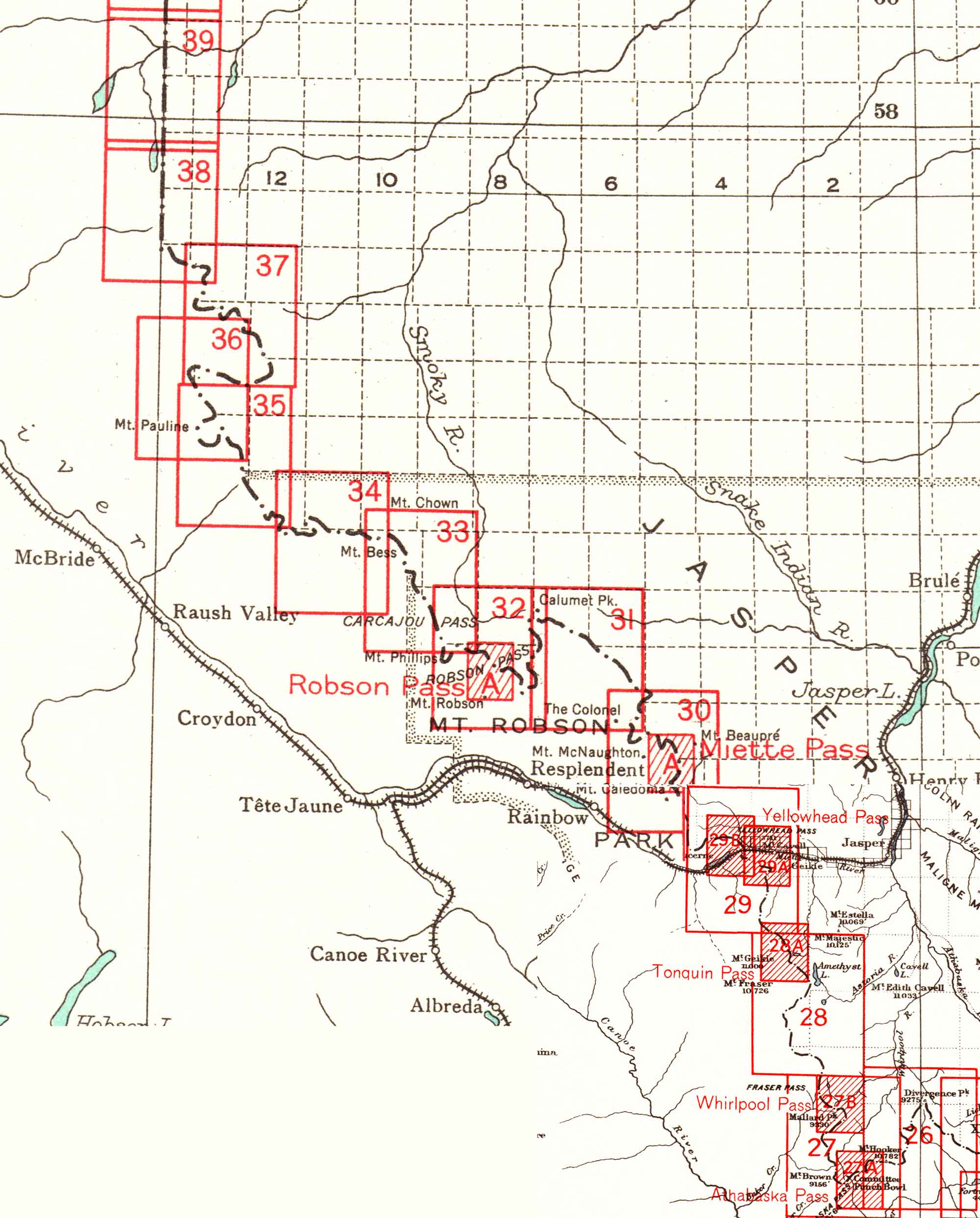
Detail from Index sheets 2 and 3. Boundary between Alberta and British Columbia. Office of the Surveyor-General, 1924 Internet Archive
Maps credited to
R. W. Cautley, D.L.S., Commissioner for the Dominion and for Alberta
A. O. Wheeler, B.C.L.S., Commissioner for British Columbia
Richard William Cautley [1873–1953], Dominion Land Surveyor, and Arthur Oliver Wheeler [1860–1945], British Columbia Land Surveyor, were commissioners appointed by the Surveyor General of Canada.
Available in high resolution on the William C. Wonders map collection, University of Alberta Library, on the Internet Archive.
Sheets relevant to the Mount Robson region:
Boundary Commission Index Sheet 2
Boundary Commission Index Sheet 3Boundary Commission Sheet 26 — Mount Brown to Whirlpool
Boundary Commission Sheet 27 — Mount Hooker to Whirlpool Pass
Boundary Commission Sheet 27 A — Athabasca Pass
Boundary Commission Sheet 27 B — Whirlpool Pass
Boundary Commission Sheet 28 — Mount Whitecrow to Tonquin Pass
Boundary Commission Sheet 29 — Yellowhead Pass.
Boundary Commission Sheet 29 A— Miette Hill to Yellowhead Pass
Boundary Commission Sheet 29 B — Yellowhead Pass to Tête Roche
Boundary Commission Sheet 30 — Mount O’Beirne to Colonel Pass
Boundary Commission Sheet 31 — Colonel Pass to Moose Pass
Boundary Commission Sheet 32 — Moose Pass to Cacajou Pass
Boundary Commission Sheet 32 A — Robson Pass
Boundary Commission Sheet 33 — Carcajou Pass to Jackpine Pass
Boundary Commission Sheet 34 — Jackpine Pass to Mount Holmes
Boundary Commission Sheet 35 — Chalco Mountain to Beaverdam Pass
Boundary Commission Sheet 36 — Great Shale Hill to Loren Lake
Boundary Commission Sheet 37 — Avalanche Pass to Casket Pass
Boundary Commission Sheet 38 — To Intersection Mountain
Boundary Commission Sheet 39 — North of Intersection to Kakwa River
- Cautley, Richard William, D.L.S., A.L.S., C.E. [1873–1953], and Wheeler, Arthur Oliver [1860–1945]. Report of the Commission Appointed to Delimit the Boundary between the Provinces of Alberta and British Columbia – Part III – from 1918 to 1924. Atlas. Ottawa: Office of the Surveyor General, 1925
- Cautley, Richard William, D.L.S., A.L.S., C.E. [1873–1953], and Wheeler, Arthur Oliver [1860–1945]. Report of the Commission Appointed to Delimit the Boundary between the Provinces of Alberta and British Columbia. Parts IIIA & IIIB, 1918 to 1924. From Yellowhead Pass Northerly. Ottawa: Office of the Surveyor General, 1925. Whyte Museum