E of Berg Lake, NE of Mount Robson
53.1439 N 119.1264 W — Map 083E03 — Google — GeoHack
Name officially adopted in 1923
Official in BC – Topo map from Canadian Geographical Names
Coleman’s map of Mount Robson 1910
Wheeler’s map Mount Robson 1912
Boundary Commission Sheet 32 (surveyed in 1922 &1924)
Boundary Commission Sheet 32 A (surveyed in 1924)
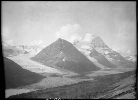
Robson Glacier, Rearguard Mountain and Mount Robson. Smithsonian-Alpine Club of Canada Mount Robson expedition.Photo: Byron Harmon, 1911 Whyte Museum of the Canadian Rockies
Kinney had accompanied Arthur Philemon Coleman [1852–1939] and Coleman’s brother Lucius on the first mountaineering expedition to Mount Robson in 1907, when they approached from the Fraser River side and got little further than Kinney Lake. They returned in 1908, guided by Adolphus Moberly [1887– ?] and John Yates [1880– ?], who took them up the Moose River valley and approached Robson from the north. They became the first people to report on Berg Lake, Tumbling Glacier, Robson Glacier, Rearguard Mountain, The Helmet, and Extinguisher Tower, features Kinney named after their appearances.
By walking a hundred yards from our camp into the valley Mount Robson came into view during the rare intervals when the clouds drifted away, disclosing an imposing dome of white rising eight thousand feet above our valley, the lower part banded with courses of rock. Immediately behind our little grove a half-mile of glacier flowed, separating us from the cliffs of the Rearguard, one of the subordinate peaks, which reached a height of about nine thousand feet.
— Coleman [2]
From his vantage on Mumm Peak during the 1911 Alpine Club of Canada–Smithsonian Robson Expedition, Arthur Oliver Wheeler [1860–1945] described the rugged ridge running from the centre of Mount Robson’s north-east face. “The ridge ends in a semi-detached rock mass, aptly named by Coleman ‘Rearguard.’”
Coleman did not claim to have named Rearguard.
Paleontologist Charles Doolittle Walcott [1850–1927] explored in the Mount Robson area in 1912:
Directly above Blue Glacier a point of rock was named by Dr. Coleman “The Helmet,” and the great black mountain in the center, which he called the “Rearguard,” is now given the Indian name of Iyatunga (Black Rock) (note: name approved by the Geographical Board of Canada, December, 1912.) [3]
“Iyatunga” is no longer official. No one seems to have used it except Walcott.
- 1. Kinney, George Rex Boyer [1872–1961]. London, England: Royal Geographical Society Archives. Letter to Arthur Hinks (1917).
- 2. Coleman, Arthur Philemon P. [1852–1939]. The Canadian Rockies: New and Old Trails. London: T. Fisher Unwin, 1911, p. 315. Internet Archive [accessed 3 March 2025]
- 3. Walcott, Charles Doolittle D. [1850–1927]. “The monarch of the Canadian Rockies.” National Geographic Magazine, (1913):626. Internet Archive