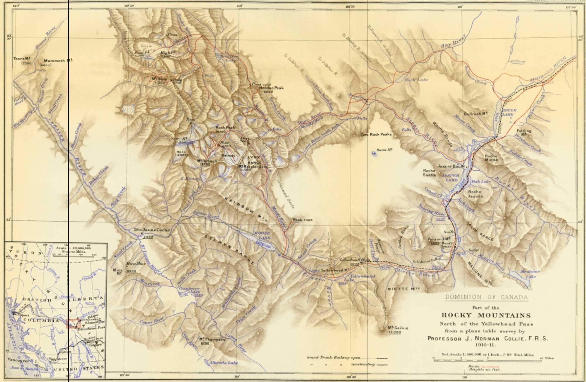
Part of the Rocky Mountains North of the Yellowhead Pass, J. Norman Collie, 1910-11
The Geographical Journal 1912
Collie was a chemist and mountaineer who lived at London, England. Between 1897 and 1911, Collie pioneered climbing in the Canadian Rockies, making twenty-one first ascents including Mount Victoria and Mount Athabasca.
This Map is from a plane table survey by Professor J. Norman Collie, based upon the map of the “Yellow-head Pass Route,” by Mr. J. McEvoy, B.A.Sc., of the Canadian Government Survey, which accompanies Part D., Vol XI., of the Report of the Geological Survey of Canada, 1900. The positions of Roche Miette, Roche Jacques, Roche Suette, and the Athabasca and Stoney rivers were laid down exactly as they are on that map, and the plane table survey of the mountainous region to the north of the Yellowhead Pass and Moose Lake adjusted to them. A traverse with the plane table was first run up the Stoney river as far as its source and Mt. Hoodoo, and rays were drawn to peaks on either side of the valley which were intersected from other points later on. Numerous photographs were taken during the expedition, many of which were used in the construction of the plane table map, and provided means of testing its general accuracy.
The position of Mt. Robson as determined by Professor Collie differs only about one mile from that given by Professor A. P. Coleman.
The heights underlined are taken from McEvoy’s map, while those in brackets are rough estimations; all others are from Collie’s readings of an aneroid, which was checked frequently by comparison with a mercurial barometer. They were computed by Collie with a mean sea-level of 30 ins., and should be considered as approximate only. In all cases the heights are above sea level.
— Note by editor of The Geographical Journal (London)
Albreda Lake
Avalanche Creek
Baker Creek (Canoe)
Beaver River
Mount Bess
Brûlé Lake
Canoe River
Colin Range
Cottonwood River
Cranberry Lake
Dominion Prairie
Mount Geikie
Grand Forks River
Grant Brook
The Helmet
Hoodoo Creek (unofficial name)
Hoodoo Peak
Horsey Creek [as “Horse Creek”]
Jasper House
Jasper Lake
King Creek
Lynx Mountain
Mammoth Mountain
McLennan River
Mica Creek
Miette River
Moose River
Moose Lake
Price Creek
Resplendent Mountain
Mount Robson
Roche Miette
Sand Creek
Shuswap River
Small Creek
Smoky River
Snaring River
Spittal Creek
Stoney River
Swift Creek
Mount Teare
Twintree Lake [as “Twin Tree Lake”]
Tête Jaune Cache
Yellowhead Lake
Yellowhead Mountain
- McEvoy, James [1862–1935]. Report on the geology and natural resources of the country traversed by the Yellowhead Pass route from Edmonton to Tête Jaune Cache comprising portions of Alberta and British Columbia. Ottawa: Geological Survey of Canada, 1900. Natural Resources Canada
- Mumm, Arnold Louis [1859–1927]. “Mount Robson District. Mumm and Collie’s 1910 Journey.” Alpine Journal, Vol. 25 (1910–1911):466
- Collie, John Norman [1859–1942]. “Exploration in the Rocky Mountains North of the Yellowhead Pass.” The Geographical Journal (London), 39 (1912):223-233. JSTOR
- Collie, John Norman [1859–1942]. “On the Canadian Rocky Mountains north of the Yellowhead Pass.” Alpine Journal, Vol. 26 (1912):5-17
- Collie, John Norman [1859–1942]. “Early Expeditions of the Rocky Mountains.” Alpine Journal, Vol. 33 (1920–1921):319