Indigenous people
These Indigenous people appear on:
Harmon’s map interior of North America 1820 [as “Cree or Knisteneaux Indians”]
Harmon’s map interior of North America 1820 [as “Cree or Knisteneaux Indians”]
Also see
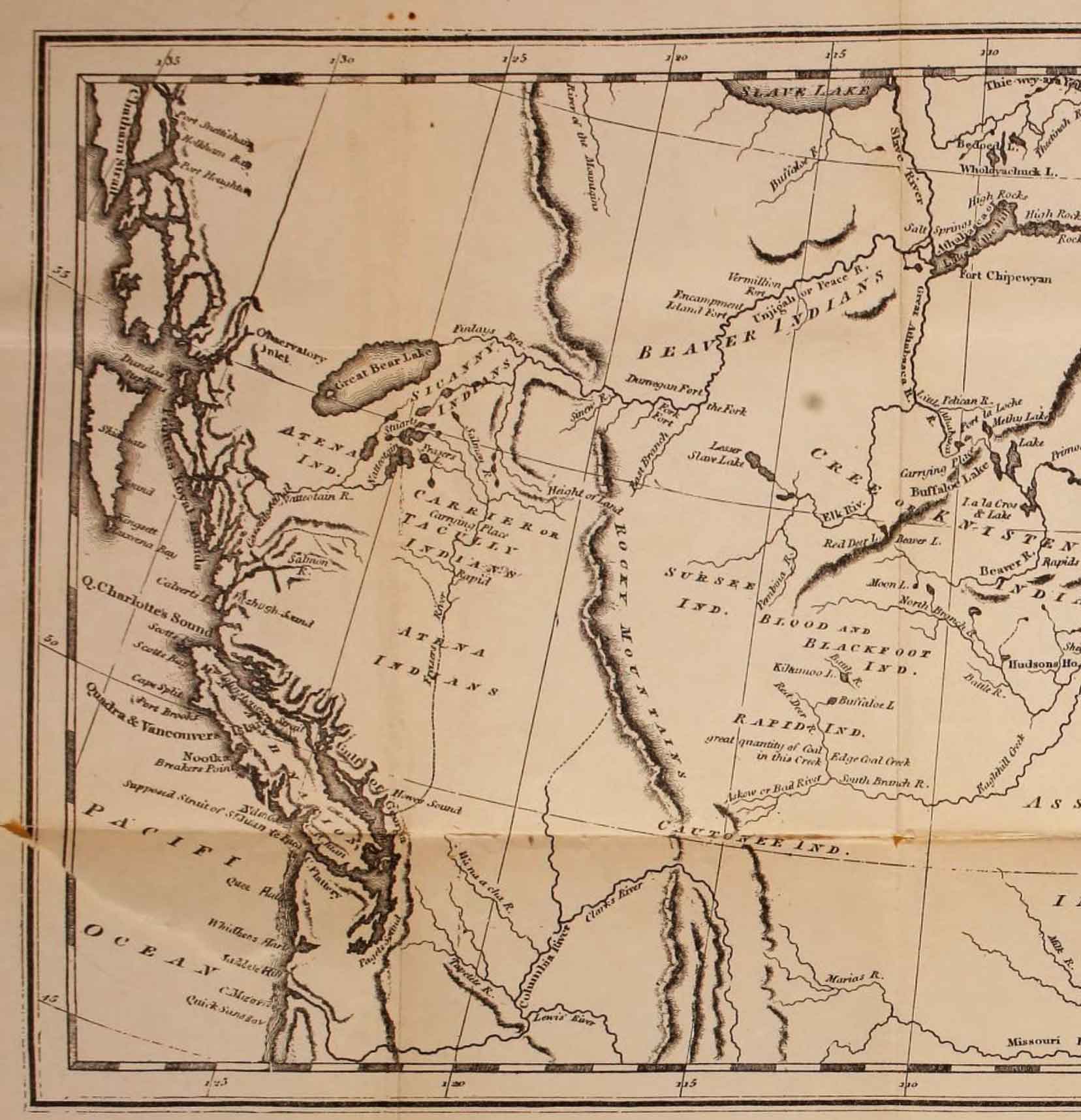
Map of the interior of North America (detail), engraved for Harmon’s Journal
On Palliser map, E of Rockies, N of Athabasca River
Named in association with McGregor River, in turn after Captain James Herrick McGregor [1869–1915], killed in action in World War I.
James Herrick McGregor became a Provincial Land Surveyor in 1891 and did much of the exploration and survey work in the area around this townsite.
Dewey Post Office was opened 1 February 1915. Dewey (Station) and Dewey (Post Office) labelled about 1 1/2 miles apart on BC map 3A, 1915 et seq, in Lots 3115A and 3111 respectively. Dewey Post Office was closed temporarily in January 1929 according to Melvin & Topping’s 1965 book The Post Offices of British Columbia. “Dewey (Post Office & Station), population 125, with school…” identified in the 1930 BC Gazetteer.
A considerable mis-sortation of mail is occurring due to similarity of Dewdney and Dewey post office names… residents requested change to Cornel, as post office is near Cornel Sawmills.” (April 1956 letter from Post Office Department, file P.1.47). Dewey Post Office renamed Cornel Mills Post Office 2 July 1956.
“We would like to call the community McGregor…150 people in residence now… likely will increase to 200…” (October 1965 letter from Northwood Pulp Ltd to Department of Municipal Affairs, file Mc.1.58). Advance notice that post office name would be changed provided in January 1966 letter from Post Office Department to Geographic Board. Cornel Mills Post Office renamed McGregor Post Office 11 April 1966. Post Office was closed 8 October 1970. At the time of closing, the post office was located in L3083, about 3 miles downstream from the original Dewey post office. (1)
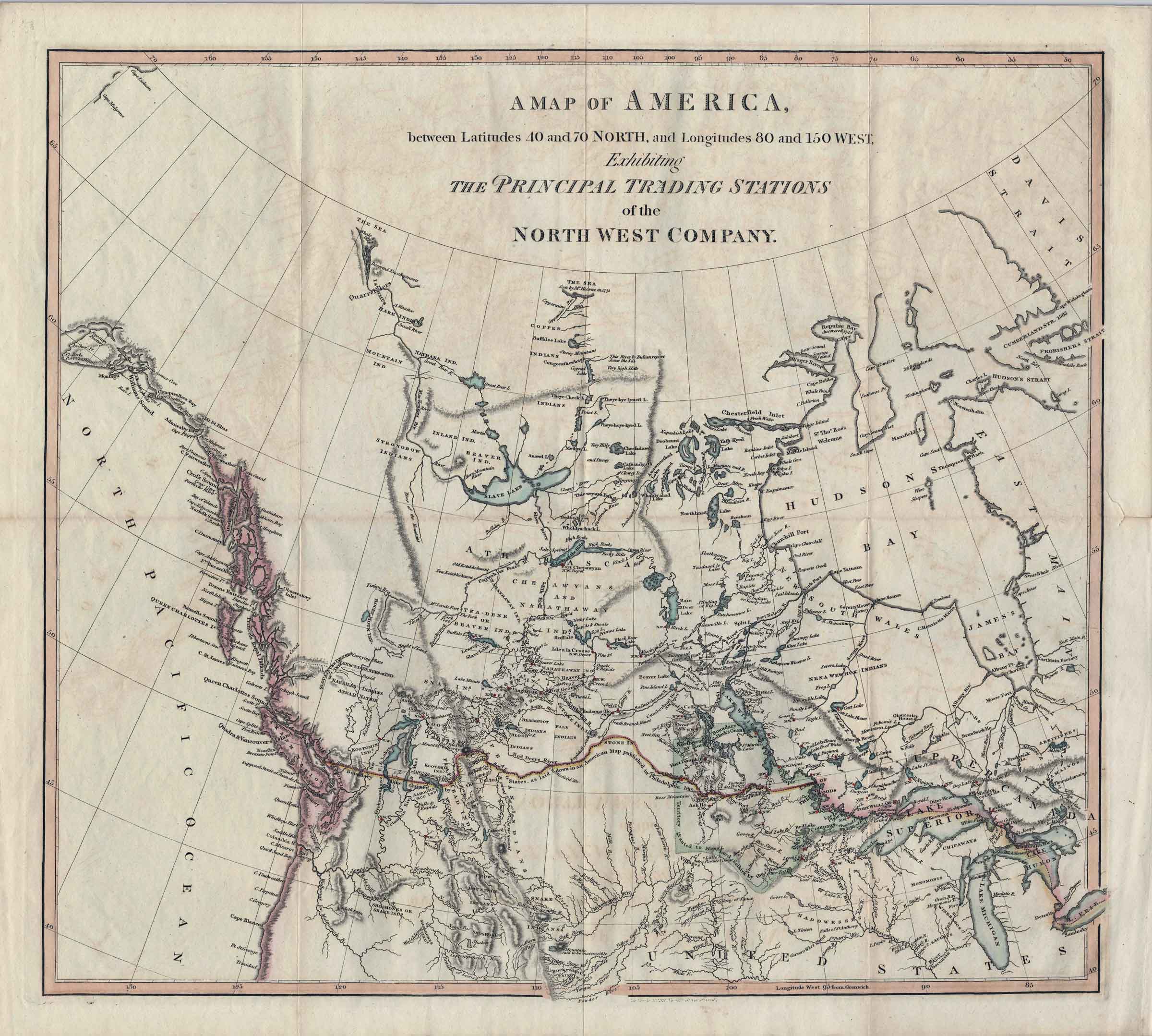
A map exhibiting the principal trading stations of the North West Company, 1817
University of British Columbia Library
![A map exhibiting the principal trading stations of the North West Company,1817 [detail]](/wp-content/uploads/2025/01/1817-McGillivray-Notice-detail.jpg)
A map exhibiting the principal trading stations of the North West Company,1817 [detail]
University of British Columbia Library
A Map of America,
Between Latitudes 40° and 70° North, and Longitudes 80° and 150° West,
Exhibiting the Principal Trading Stations of the
North West Company.
The map appears in Notice respecting the boundary between His Majesty’s possessions in North America and the United States, 1817, a 12-page booklet attributed to Simon McGillivray [1785–1840]. [1] McGillivray played a role in merging the family-owned North West Company with the rival Hudson’s Bay Company in 1821.
This map is similar to Sax’s map of North America, 1818.
This map is cited by Ernest Voorhis [1859–1933] in Historic Forts and Trading Posts as Map No. 5, “America exhibiting principal trading stations of North West Co. in Davidson’s North West Co., London 1817” [2]. Gordon Charles Davidson [1884–1922] published The North West Company in 1918, containing the same map [3].
![Alex Caulfield Anderson [ca. 1865]](/wp-content/uploads/2024/12/ac-anderson.jpg)
Alex Caulfield Anderson [ca. 1865]
BC Archives A-01076
Alexander Caulfield Anderson
b. 10 March 1814 — Calcutta, India
d. 8 May 1884 — Victoria, B.C.
In 1832 the HBC assigned Anderson to the Columbia fur trade district. Accompanying the Columbia express brigade, Anderson crossed the Athabasca Pass in October.
He was promoted to chief trader in 1846, and would have been made chief factor had he been willing to accept a post in New Caledonia. Between 1846 and 1847, in response to the Oregon boundary issue, Anderson led three exploring expeditions in an attempt to find a route, from the HBC post at Kamloops to the HBC post Fort Langley, which would fall entirely within British territory.
He retired from the Company in 1854, and settled with his wife Eliza Birnie, whom he married in 1837, in Cathlamet, Washington. They eventually had 13 children. In 1858 Anderson was persuaded by James Douglas [1803–1877], governor of Vancouver Island and of the crown colony of British Columbia, to accept the position of postmaster of Victoria; he later served briefly as collector of customs, and also had various business interests in Victoria. In 1876 he was appointed as both Dominion inspector of fisheries and the federal representative on the Dominion-Provincial Joint Commission on Indian Land in British Columbia. His appointment to this commission ended in 1878. Anderson was considered scholarly, and wrote several reports, articles and manuscripts about the history of the northwest coast. [1, 2, 3]
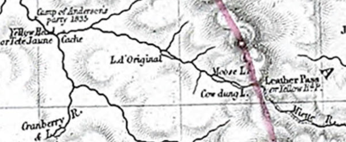
Detail of Tête Jaune Cache area, John Arrowsmith map,1859
Colonial Dispatches, Uvic
The Hudson’s Bay Company party of Alexander Caulfield Anderson [1814–1884] cached canoes and contents here in October 1835:
The winter of 1835-36 is here referred to. Crossing the Rocky Mountains from Tête Jaune’s Cache to Jasper’s in September, on foot, I had returned with a party of some 22 persons, with horses. After embarking in our canoes and descending Fraser River a few miles, we were ice-bound — the winter being premature in an unwonted degree — about the 23rd of October. Short of provisions, and unable to make our way downwards owing to the unequally frozen condition of the stream, we made a cache of the canoes and their contents, at a point noted in Arrowsmith’s map, and retraced our steps to Jasper’s — the snow being about nine inches deep at the Summit of the Pass The supplies obtainable at Jasper’s were inadequate to our wants; and we had to continue our retreat down the Athabasca, and across to Edmonton on the Saskatchewan. There we obtained copious supplies, with dog-sledges to convey them. Leaving some of the party there, to follow in the Spring, we set out on our return. We had experienced some little difficulty on the way down: but the return-trip, being now provided with snow-shoes, warm clothing, and plenty of pemican, was performed with comparative comfort, —the journey from Edmonton to Stuart’s Lake occupying only 46 days. It was on this return trip that the observations noted in the text were made. The depth of the snow for a short distance at the summit of the Pass was about eight feet—but it was melting very fast at the period of our passage, about the 1st January, and there was a warm rain falling. (1)