Gabriel Franchère
Wikipedia
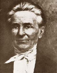
Gabriel Franchère
b. 3 November 1786 — Montréal, Quebec
d. 12 April 1863 — St. Paul, Minnesota
On the morning of the 14th of May we began to climb the mountain, which is very steep. Fortunately the preceding night had been cold and the snow was frozen hard enough to carry our weight. We had to rest every few minutes, the climb being very difficult and the exercise exhausting. Finally after two or three hours of unbelievable effort and fatigue we reached the summit and followed in the footprints of those who had gone before us. Our route lay between two high mountains and soon became tiring because of the depth of the snow, which being softened by the sun’s rays, could no longer bear our weight as it had done in the morning, so that we had to walk in the footsteps of those ahead of us, sinking up to our knees as if putting on an enormous pair of boots at each step. At last we came to a hollow that our guide said was a small lake, though we could not recognize it as it was covered in snow, and we stopped there for the night. These lakes (for there are two) are situated at the summit of the face of the mountain [1].
(The lakes are the Committee Punch Bowl.)
- — Relation d’un voyage à la Côte du Nord-Ouest de l’Amerique Septentrionale. Montréal: 1820
- — and Lamb, William Kaye [1904–1999], editor. Journal of a Voyage to the Northwest Coast of America, in the years 1811, 1812, 1813, and 1814. Toronto: Champlain Society, 1969. Internet Archive [accessed 3/10/2025]
- 1814 Franchère crosses Athabasca Pass
- 1. Franchère, Gabriel [1786–1863], and Lamb, William Kaye [1904–1999], editor. Journal of a Voyage to the Northwest Coast of America, in the years 1811, 1812, 1813, and 1814. Toronto: Champlain Society, 1969, P. 159. Internet Archive [accessed 10 March 2025]