Monthly Archives: March 2014

Tatei Ridge

Alberta-BC boundary. Ridge
E of Berg Lake
53.1608 N 119.0794 W — Map 83E/3 — GoogleGeoHack
Name officially adopted in 1956
Official in BCCanada

“Tatei” is the Nakoda or Stoney word for “wind.”

“Tatei Ridge” is listed at the Indigenous Geographical Names dataset as a word of Stoney language.

References:

  • Canadian Board on Geographical Names. Place-names of Alberta. Published for the Geographic Board by the Department of the Interior. Ottawa: Department of the Interior, 1928. Hathi Trust
  • Holmgren, Eric J., and Holmgren, Patricia M. Over 2,000 place names of Alberta. Saskatoon, Saskatchewan: Modern Press, 1973. Internet Archive
Swiftwater station

British Columbia. Railway Point
Canadian National Railway, E of Tête Jaune Cache
52.9819 N 119.3 W — Map 83D/14 — GoogleGeoHack
Name officially adopted in 1989
Official in BCCanada
40 miles west of the Yellowhead Pass on the Canadian National Railway
Mile 14 in Tete Jaune Subdivision (Red Pass to McBride as of 1977)
Grand Trunk Pacific Railway station built in 1913

Origin of the name unknown.

Swiftcurrent Creek

British Columbia. Creek: Fraser River drainage
Flows SE into Fraser River, SW of Robson River
53.0167 N 119.2667 W — Map 83E/3 — GoogleGeoHack
Earliest known reference to this name is 1898 (McEvoy)
Name officially adopted in 1951
Official in BCCanada

“Swift-current River is an erratic, turbulent stream fed by glaciers. It may sometimes be forded without difficulty in the morning and the same evening be utterly impassable,” wrote James McEvoy [1862–1935], who surveyed the area in 1898.

That same year a placer strike was made on the creek and several prospecting parties flocked in. After working for a season without finding enough gold to pay their expenses, they left.

References:

  • McEvoy, James [1862–1935]. Report on the geology and natural resources of the country traversed by the Yellowhead Pass route from Edmonton to Tête Jaune Cache comprising portions of Alberta and British Columbia. Ottawa: Geological Survey of Canada, 1900. Natural Resources Canada
  • MacGregor, James Grierson [1905–1989]. Overland by the Yellowhead. Saskatoon: Western Producer, 1974. Internet Archive

Swift Creek (railway point)

British Columbia. Former railway station
Canadian National Railway, head of Canoe River
Earliest known reference to this name is 1918
Not currently an official name.
54 miles west of the Yellowhead Pass on the Canadian National Railway
Mile 72 in Albreda Subdivision (Jasper to Blue River as of 1977)
Canadian Northern Railway station built in 1915
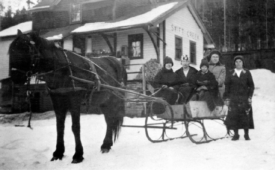
Katherine Blackman, Betty Cox, Mrs. Minnard and Mrs. Couture outside Swift Creek station, 1924

Katherine Blackman, Betty Cox, Mrs. Minnard and Mrs. Couture outside Swift Creek station, 1924
Valemount & Area Museum

The Cranberry Lake post office was changed to Swift Creek in 1918. In 1927, the Canadian National Railway decided to move the Swift Creek railway station and name it Valemount, the “valley in the mountains.”

References:

  • Topping, William. A checklist of British Columbia post offices. Vancouver: published by the author, 7430 Angus Drive, 1983
  • Bohi, Charles W., and Kozma, Leslie S. Canadian National’s Western Stations. Don Mills, Ontario: Fitzhenry & Whiteside, 2002

Swift Creek

British Columbia. Creek: Fraser River drainage
Flows SW into McLennan River at Valemount
52.85 N 119.3 W — Map 83D/14 — GoogleGeoHack
Earliest known reference to this name is 1900 (McEvoy)
Name officially adopted in 1951
Official in BCCanada

Descriptive.