British Columbia. Unofficial name
S of Mount Robson, E of Kinney Lake
53.0975 N 119.1389 W Google — GeoHack
Not currently an official name.
S of Mount Robson, E of Kinney Lake
53.0975 N 119.1389 W Google — GeoHack
Not currently an official name.
In 1911, Arthur Oliver Wheeler [1860–1945] named this mountain Little Grizzly Peak “on account of its resemblance, on a small scale, to Mount Grizzly in the Selkirks.” Cinnamon is a coloration of the grizzly bear.
LINDUP: a settlement on the G. T. P. Ry., 5 miles west of Penny, no agent, in Prince George Provincial Electoral District. Has Canadian Express. Charges must be prepaid; tele- graph office.
Population 5. Local resources: Saw mills and mixed farming. Heavily timbered unbroken land about 3 miles distant from the mountains.
Address mail Lindup via Penny or Longworth.
Bochscski M section hand
Hall Harold farming
Jardine Carl section foreman
Jardine Chas farming
Lehman F farming
Persons G homesteader
Segel G lineman G T P— Wrigley 1918
Torsten Berg was the only one to operate a sawmill at Lindup. The mill operated from 1949 to 1952, at which time his timber supply ran out and he moved the mill to Longworth. The timber at Lindup was of nice quality and of good size. Torsten was awarded the contract to supply planks 26 feet long, for the podium for Queen Elizabeth’s coronation in 1952.
The population of Lindup peaked at about 50 people in 1929 and dwindled dramatically the Depression. In 1931 the Prince George Citizen reported that a large relief camp of 100 men were clearing and grubbing road right of way.
Lindup in 2014 does not have any residents and is on a seasonal road that is susceptible to weather restrictions.
— Olson
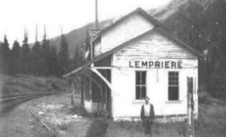
Lempriere Station, from the late 1970s/early 1980s. Photo by Brian Lempriere
Real Royal Engineers
Arthur Reid Lempriere [1835–1927], a lieutenant in the Royal Engineers, arrived in Esquimalt in 1859 with the main body of the Columbia Detachment, the third and largest group of Royal Engineers to come to British Columbia. In 1859 he explored the route from Hope to Lytton via the Coquihalla. Lempriere returned to England in 1863, and retired as Major General in 1882.
The Canadian Northern Railway laid tracks through the Valemount area in 1915 and Lempriere first appears on a map of 1917. The Lempriere post office was open from 1942 to 1945. Less than ten cancellation marks are known in collections. There was a Japanese internment camp here during World War II.
Proximity to Lempriere.
The community was named after Joseph G. Legrand [1861-1923], a French-born engineer who designed and supervised the construction of all of the bridges on the Grand Trunk Pacific Railway. Legrand emigrated to Canada in 1891. Between 1893 and 1903 he worked successively as a draftsman, checker, and designer of bridge work and in 1903 was appointed assistant chief engineer of the predecessor firm that became the Montreal Locomotive Works. He joined the Grand Trunk Pacific Railway in 1906, at age 45, and assumed responsibilty for designing and overseeing the building of all the bridges on the new railway, thus becoming one of its senior managers.
Fourteen miles west of McBride, Legrand became a farming community. In 1921 six farmers lived there. The Legrand post office was open from August 1924 to June 1925, under postmaster Mrs. Janetta Somerville.
Ed Lee homesteaded in Dunster in 1915. After serving overseas in the First World War, he built up a farm, selling potatoes, carrots, and turnips to logging camps. He had the first team of horses in the Dunster area, and later owned one of the first cars around Dunster.
Origin of the name unknown.