Near headwaters of Pinkerton Creek, SW. of Tumuch Lake
53.6261 N 121.5436 W — Map 093H12 — Google — GeoHack
Name officially adopted in 1924
Official in BC – Canada
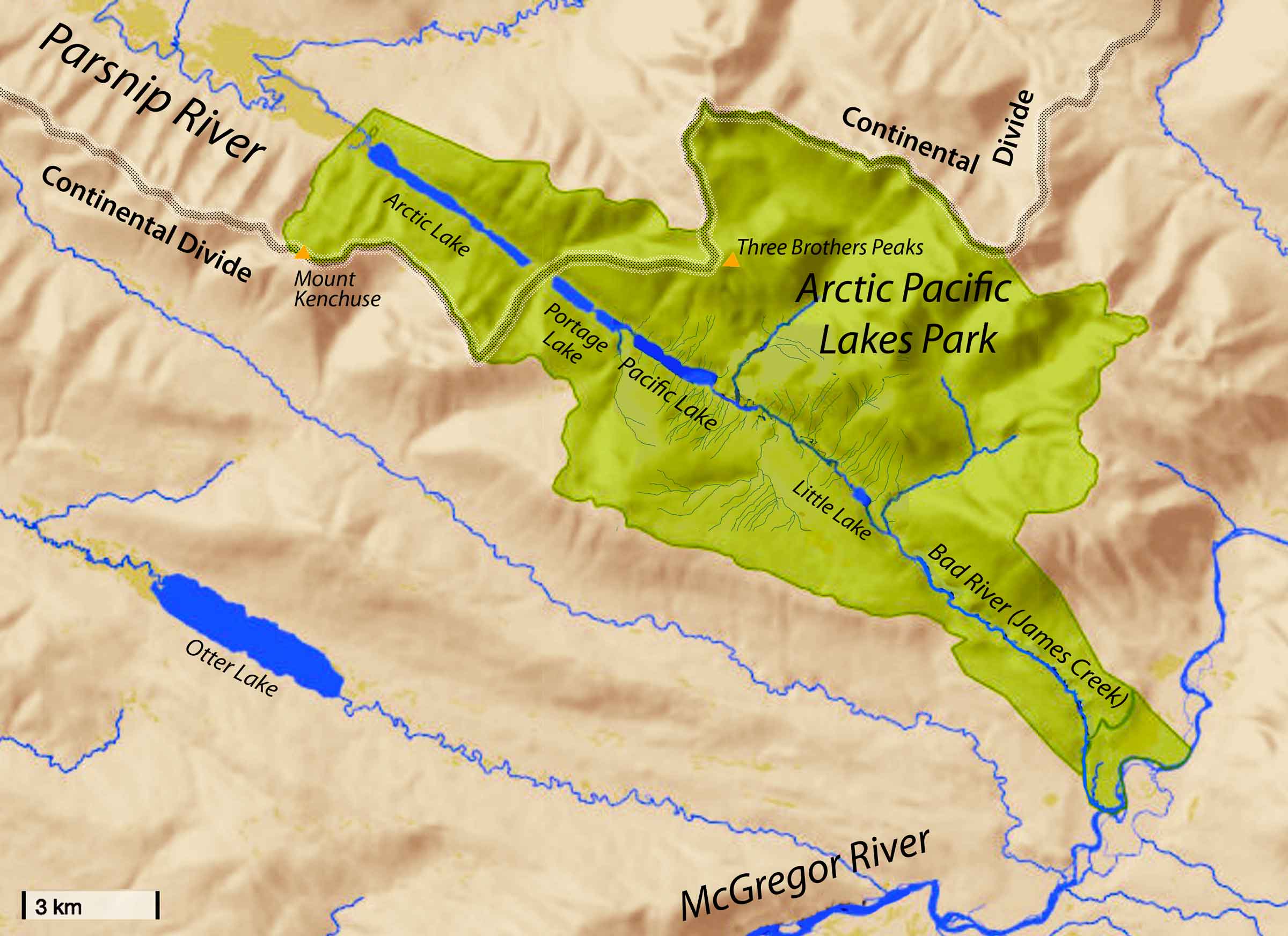
Association with Pinkerton Creek.
When a name for this creek was required for a water licence application, the British Columbia Geographical Names Office chose Abrams Creek to recall Ted Abrams, a Tête Jaune trapper from the years before the First World War who participated in the McBride trappers’ exchange for many years.
Adopted in 1974 as submitted in 1970 by A.C. Van Der Postpf the British Columbia Forest Service. Named in BC’s Centennial Year, 1971.
David Thompson, events of January 1811:
Our residence was near the junction of two Rivers from the Mountains with the Columbia: the upper Stream which forms the defile by which we came to the Columbia, I named the Flat Heart, from the Men being dispirited ; it had nothing particular. The other was the Canoe River ; which ran through a bold rude valley, of a steady descent, which gave to this River a very rapid descent without any falls…
Thompson’s “Flat Heart ” river is now Wood river. It is clear from this text that both the Athabaska Pass and the Canoe river region had been visited earlier than this by the guide, Thomas the Iroquois, and by other Nipissing and Iroquois Indians ; but Thompson was the first white man to cross it.
Origin of the name unknown.

Grand Trunk Pacific survey supplies being freighted through the Grand Canyon of the Fraser River. Arthur H. Holland, 1907
Northern British Columbia Archives
Owing to the vicious character of the river this task was one beset with innumerable difficulties. Forty miles outside of Fort George is a furious rush of water over 9 miles in length — the Giscombe Rapids — where the water bubbles, froths, and speeds along at a terrific pace over a shallow bed littered with chisel-pointed rocks. Some 60 miles beyond is the Grand Canyon of the Upper Fraser, which is a veritable death-trap, where the inexpert, as well as the dexterous water-dog, often has met his end. Even the Indians for the most part regard it with a certain awe, especially during certain periods of the year, when it is little better than a maelstrom, and wherein several members of their tribe have met their Waterloo. The third danger is the Goat Rapids, a little west of the Goat River, where the river tumbles downhill very suddenly, and where, in order to negotiate the boiling water, skilful navigation is imperative to manoeuvre the boat from one side to the other of the river in order to avoid terrible obstacles.
— Talbot 1912
From Mile 53 — this mileage is reckoned from the Summit at Yellowhead Pass along the railway — the [Fraser] river is navigable in high water as far as Soda Creek, a distance of nearly 500 miles. The Fraser has proved to be invaluable to the building of the Grand Trunk Pacific Railway, despite the fact that so many lives and so much property have been lost in its waters. These accidents have happened mostly through carelessness and ignorance. The chief obstacles to navigation are due to the existence of shifting sand and gravel bars, the Goat Rapids, the Grand Canyon, and the Giscome Rapids, all above Fort George. High water minimizes this danger for the larger craft, but presents sometimes greater dangers for the smaller ones.…
— Walker 1914