Flows SW into N Thompson River SW of junction with Albreda River
52.5333 N 119.4667 W — Map 83D/11 — Google — GeoHack
Name officially adopted in 1961
Official in BC – Canada
Zillmer maps of Cariboo 1939-1948 [1947]
Origin of the name unknown.
Origin of the name unknown.
Gerald (b. 1948) and Linda (b. 1950) Pitney moved to the Valemount area in 1973. Gerald, who was born in Vancouver, has worked as school bus driver and manager of the Valemount ice arena. Linda, born in Brandon, Manitoba, has worked at local stores.
Named after a former Canadian National Railway roadmaster.
Feature type: road
Province: British Columbia
Location: Forks off Goslin Road, Téte Jaune area
Latitude: 52.9885
Longitude: 119.4587
Origin of the name unknown. Likely named by the surveyors of the Alberta-British Columbia Boundary Commission.
George (1899-1978) and Pearl (b. 1904) Pepper came to Dunster from Calgary in 1958. George was born in Calgary, and Pearl in Poplar Point, Manitoba. Pearl’s family moved to Saskatchewan in 1910, and George’s in 1918. They were married in Saskatchewan in 1924, and farmed there until moving to Alberta in 1937. From 1942 to 1955, George was in the Army and the civil service.
In 1955 he returned to Calgary where he worked and drove stage for the Brewster Line and also was a packer for the Brewster’s at Banff and for the lodge at the Columbia Icefields.
George suffered from poor health and couldn’t stand hard work. After their move to Dunster, they farmed with horses, and when they eventually got a tractor, George couldn’t use it because of his health. Their house burnt in 1963, and they sold their property. In 1974 they moved to McBride.
Named in 1949 by alpinist Arnold Wexler [1918–1997] after a penny found in a sardine can left by explorers Edward Willet Dorland Holway [1853–1923] and Andrew James Gilmour [1871–1941]
in 1916.

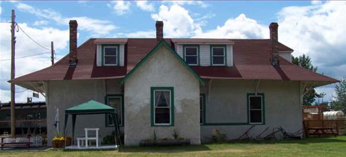
The Penny Grand Trunk Pacfic station at its new home at the Central BC Railway & Forestry Museum in Prince George
Exploration Place — Central BC Railway & Forestry Museum
Wrigley’s Directory for 1918 lists:
Penny — a post office and station on the G. T. P. Railway, 76 miles east of Prince George.
Nearest G. T. P. telegraph office is at Lindup, 4 1-2 miles.
Population, 50 to 85.
Local resources: Timber and lumbering.
Local lumber mills included Penny Lumber Co Ltd (mfrs fir and hemlock lumber) and Red Mountain Lumber Company, Roy Spur and Thomas Wall, proprietors.
Type E stations, of which the Penny Station was one, where once common along the GTP/CNR tracks west of Winnipeg, but now few remain. It was decided that the station would be relocated once again, to the Prince George Railway & Forestry Museum. In 1986 plans for the new move began. It was determined that an ice bridge over the Fraser River (there was no bridge in Penny) needed to be built. The station would be transported by truck across the river and up a steep grade to the highway on the south side which went to Prince George. Volunteers and workers had to wait until the river was frozen thick enough to carry the 45 – 50 tonne station across, which required 4 sets (8) tires at each end of the building. Finally in 1987/1988 it was cold enough to try to move the station. The station was brought to Prince George in two sections. Three chimneys and the built-on kitchen were removed and brought in separately. It took 4 days to go the 140 km to Prince George. The total load was too wide (960 cm) and long (1935 cm) to easily negotiate corners in the road or pass over bridges. Hydro lines had to be raised, private fences removed and replaced, permits had to be acquired, but finally the station arrived at the museum on February 13, 1988.
The Penny Post office opened in February, 1916.
In fortifications, a parapet is a defence of earth or stone to cover troops from the enemy’s observation and fire. The name was suggested by shape and by association of sound with Paragon Peak, continuing the fortification theme established by interprovincial boundary surveyors in the 1920s. The name does not appear on the 1924 Alberta-British Columbia Boundary Commission maps.
Cyril G. Wates [1883–1946] explored the area in 1924, writing at one point that “our first care was to select a sleeping place and protect it from the wind. A flat spot was found with a large rock making a natural wall on one side, and we then proceeded to complete our house by enclosing the other three sides with a parapet about two feet high, over which we fastened one of our canvas squares, propping the centre with one of the axes.” Wates returned in 1933, writing, “We passed close under the cliffs of Parapet Peak.”