Flows W into Canoe Reach of Kinbasket Lake
52.2669 N 118.4944 W — Map 083D07 — Google — GeoHack
Earliest known reference to this name is 1895
Name officially adopted in 1974
Official in BC – Canada
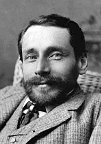
Dawson in 1885
Wikipedia
Adopted in 1954 on Columbia River Basin manuscript 75 as labelled on 1895 map of British Columbia; not “Boulder Creek” as labelled on 1911 map of Kootenay District, flowing into Canoe River.
Coordinates of mouth altered and description changed in 1974, following creation of reservoir behind Mica Dam; now flows west into Canoe Reach, Kinbasket Lake.
Presumably refers to George Mercer Dawson [1849–1901], given the early use of the name.
Dawson was a Canadian geologist and surveyor who performed many early explorations in western North America and compiled numerous records of the native peoples, including the Shuswap who were inhabitants of this area.
The Kamloops Indians affirm, that the very highest mountain they know is on the north side of the valley at Tête Jaune Câche, about ten miles from the valley. This is named Yuh-hai-has’-kun, from the appearance of a spiral road running up it. No one has ever been known to reach the top, though a former chief of Tsuk-tsuk-kwälk’, on the North Thompson, was near the top once when hunting goats. When he realized how high he had climbed he became frightened and returned.
— Notes on the Shuswap People of British Columbia, 1891
Dawson was director of the Geological Survey of Canada from 1895 until his death in 1901.
- Tolmie, William Fraser [1812–1886], and Dawson, George Mercer [1849–1901]. Comparative Vocabularies of the Indian Tribes of British Columbia, with a Map Illustrating Distribution. Ottawa: Geological and Natural History Survey of Canada, 1884. Toronto Public Library
- Dawson, George Mercer [1849–1901]. “Notes on the Shuswap people of British Columbia.” Transactions of the Royal Society Canada, Section 2 (1891). University of British Columbia
- McConnell, Richard George [1857–1942], and Dawson, George Mercer [1849–1901]. Report on an exploration of the Finlay and Omenica rivers. Ottawa: Geological Survey of Canada, 1896. University of British Columbia Library
- British Columbia Geographical Names. Dawson Creek