Category Archives: Place

Interpass Ridge

Alberta-BC boundary. Ridge
Between Avalanche Pass and Beaverdam Pass
53.6086 N 119.9311 W — Map 083E12 — GoogleGeoHack
Name officially adopted in 1925
Official in BCCanada

Possibly named by the Alberta-British Columbia Boundary Commission in 1923.

References:

  • Cautley, Richard William [1873–1953], and Wheeler, Arthur Oliver [1860–1945]. Report of the Commission appointed to delimit the boundary between the Provinces of Alberta and British Columbia. Part II. 1917 to 1921. From Kicking Horse Pass to Yellowhead Pass.. Ottawa: Office of the Surveyor General, 1924. Whyte Museum
  • Cautley, Richard William [1873–1953], and Wheeler, Arthur Oliver [1860–1945]. Report of the Commission Appointed to Delimit the Boundary between the Provinces of Alberta and British Columbia. Parts IIIA & IIIB, 1918 to 1924. From Yellowhead Pass Northerly. Ottawa: Office of the Surveyor General, 1925. Whyte Museum

Icefall Lake

British Columbia. Lake: Fraser River drainage
Headwaters of Geikie Creek
52.6669 N 118.3608 W — Map 083D09 — GoogleGeoHack
Name officially adopted in 1951
Official in BCCanada
References:

  • Cautley, Richard William [1873–1953], and Wheeler, Arthur Oliver [1860–1945]. Report of the Commission appointed to delimit the boundary between the Provinces of Alberta and British Columbia. Part II. 1917 to 1921. From Kicking Horse Pass to Yellowhead Pass.. Ottawa: Office of the Surveyor General, 1924. Whyte Museum
  • Cautley, Richard William [1873–1953], and Wheeler, Arthur Oliver [1860–1945]. Report of the Commission Appointed to Delimit the Boundary between the Provinces of Alberta and British Columbia. Parts IIIA & IIIB, 1918 to 1924. From Yellowhead Pass Northerly. Ottawa: Office of the Surveyor General, 1925. Whyte Museum

Hunga Glacier

British Columbia. Former name
Former name of Robson Glacier
Earliest known reference to this name is 1913 (Walcott)
Not currently an official name.
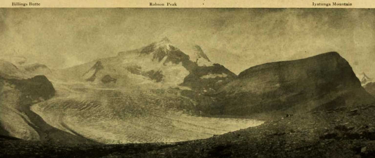
Billings Butte - Robson Peak - Iyatunga Mountain. Panonamic view of the Robson massif and adjoining mountains, with the great Hunga glacier in the foreground. 
Photo: Charles D. Walcott, 1912

Billings Butte – Robson Peak – Iyatunga Mountain. Panonamic view of the Robson massif and adjoining mountains, with the great Hunga glacier in the foreground.
Photo: Charles D. Walcott, 1912
National Geographic Magazine 1913


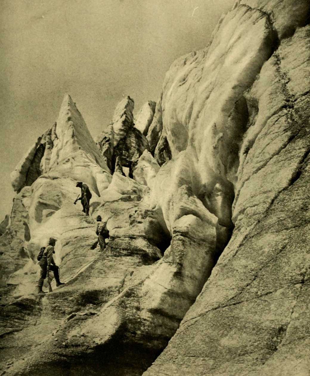
Working up through the vast and broken front of Hunga Glacier. Photo: R. C. W. Lett, 1911

Working up through the vast and broken front of Hunga Glacier. Photo: R. C. W. Lett, 1911
National Geographic Magazine 1913

Charles Doolittle Walcott, who visited the area in 1912, referred to Robson Glacier as “the great Hunga (Chief) glacier.”

“Hunga” presumably a word in an Indigenous language.

References:

  • Walcott, Charles Doolittle [1850–1927]. “The monarch of the Canadian Rockies.” National Geographic Magazine, (1913):626. Internet Archive

Hugh Allan Creek

British Columbia. Creek: Columbia River drainage
Flows NW into Canoe Reach, Kinbasket Lake
52.45 N 118.6667 W — Map 83D/7 — GoogleGeoHack
Name officially adopted in 1974
Official in BCCanada

Hugh Drummond Allan [1887–1917] was born in Scotland and came to Canada around 1907. He became a British Columbia land surveyor in 1912. His professional work was carried on mainly in the Kamloops district and the North Thompson valley. In 1913 he surveyed in the Canoe River area. “From Mile 49 on the Grand Trunk Pacific I proceeded with my party by wagon and reached the Canoe River in one day,” he reported.

After the start of the first World War Allan returned to Scotland and enlisted. In 1916 he was wounded, and in 1917 he was killed leading his company at Croiselles, France. Lieutenant Allan was shortly predeceased by his wife and infant child.

(There is another Hugh Allan [1810-1882], a Scottish-Canadian shipping magnate, apparently unrelated.)

References:

  • Allan, Hugh Drummond [1887–1917]. “Canoe River Valley.” Report of the Minister of Lands, (1914)
  • Corporation of Land Surveyors of the Province of British Columbia. Annual Reports (1956)., 1956
  • Andrews, Gerald Smedley [1903–2005]. Métis outpost. Memoirs of the first schoolmaster at the Métis settlement of Kelly Lake, B.C. 1923-1925. Victoria: G.S. Andrews, 1985