Monthly Archives: March 2014

Colonel Pass

Alberta-BC boundary. Pass
Between Colonel Creek and Snaring River
53.0833 N 118.7667 W — Map 83E/2 — GoogleGeoHack
Earliest known reference to this name is 1922
Name officially adopted in 1923
Official in BCCanada

Named in association with “The Colonel” (mountain).

Also see:

Colonel Creek

British Columbia. Creek: Fraser River drainage
Flows W into Moose River NW of Salient Mountain
53.0736 N 118.8622 W — Map 083E02 — GoogleGeoHack
Name officially adopted in 1923
Official in BCCanada

Named in association with “The Colonel” (mountain). Adopted in 1923 as labelled on Wheeler’s map of Mount Robson (1912).

Also see:

Coleman Glacier

Alberta. Glacier: Smoky River drainage
Head of Smoky River
53.1781 N 119.0478 W — Map 083E03 — GoogleGeoHack
Name officially adopted in 1956
Topo map from Canadian Geographical Names
This glacier appears on:
Wheeler’s map Mount Robson 1912
Dr. A. P. Coleman. Lantern slide by Mary T. S. Schäffer Warren, 1907.

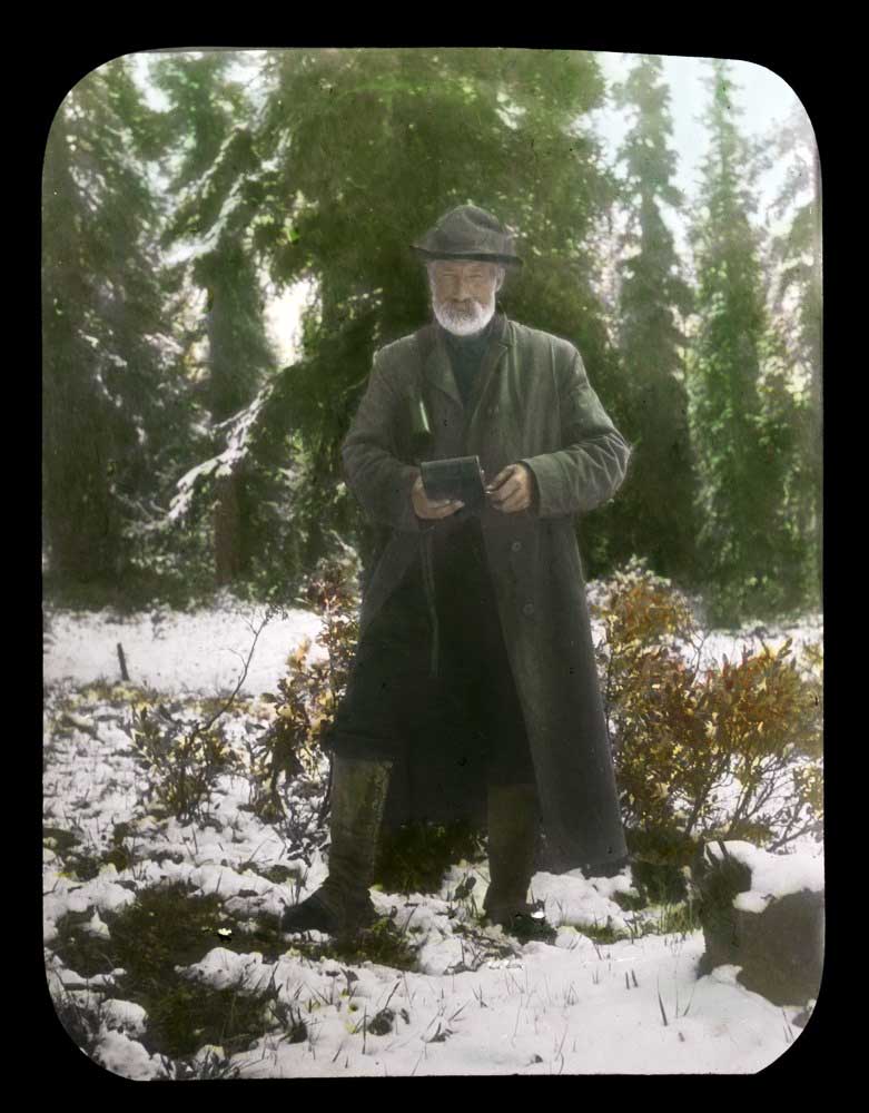
Dr. A. P. Coleman. Lantern slide by Mary T. S. Schäffer Warren, 1907. Whyte Museum of the Canadian Rockies, Moore family fonds

Arthur Philemon Coleman [1852–1939], a professor of geology at the University of Toronto, was the first person of European descent to attempt to climb Mount Robson, mounting unsuccesful attempts in 1907 and 1908.

The first mention of the name is in the report of Arthur Oliver Wheeler [1860–1945] on the Alpine Club Of Canada’s 1911 expedition to Jasper Park, Yellowhead Pass and the Mount Robson region:

The Yates trail comes out in an open at the highest point. It might well be called “Exclamation Point.” Looking south in the V of the valley, Mt. Resplendent stands a great white cone, clad from head to foot in eternal snows. Below, to the left, Yates Torrent issues from the forefoot of Coleman Glacier, a splendid icefall, the main northern outflow of Reef Névé.

References:

  • Coleman, Arthur Philemon [1852–1939]. “Expedition to Mt. Robson.” Canadian Alpine Journal, Vol. 1, No. 2 (1908):100-103. Alpine Club of Canada
  • Coleman, Arthur Philemon [1852–1939]. “Mount Robson, the Highest Point in the Canadian Rockies.” The Geographical Journal (London), Vol. 36, No. 1 (July 1910). JSTOR [accessed 3 March 2025]
  • Wheeler, Arthur Oliver [1860–1945]. “The Alpine Club of Canada’s expedition to Jasper Park, Yellowhead Pass and Mount Robson region, 1911.” Canadian Alpine Journal, Vol. 4 (1912):9-80. Alpine Club of Canada

Cloud Cap Mountain

British Columbia. mount
Other name of Mount Robson

The earliest known description of Mount Robson is found in the journal of John M. Sellar. Sellar was an “Overlander,” members of parties of gold-seekers bound for the Cariboo. Sellar’s party passed the peak on August 26, 1862. “At 4 pm we passed Snow or Cloud Cap Mountain which is the highest and finest on the whole Leather Pass. it is 9000 feet above the level of the valley at its base, and the guide told us that out of 29 times that he had passed it he had only seen the top once before.”

Eleven months after the passage of John Sellar, on July 14, 1863, Viscount Milton and Dr. W.B. Cheadle passed the mountain in the course of their overland journey of adventure to the Pacific Coast. Their book contains the earliest known description of Mount Robson by name.

References:

  • Talbot, Frederick Arthur Ambrose [1880–1924]. The making of a great Canadian railway. The story of the search for and discovery of the route, and the construction of the nearly completed Grand Trunk Pacific Railway from the Atlantic to the Pacific with some account of the hardships and stirring adventures of its constructors in unexplored country. London: Seely, 1912. Internet Archive
  • Harvey, Athelstan G. “The mystery of Mount Robson.” B.C. Historical Quarterly, (1937)
Also see:

Clemina

British Columbia. Railway Point
CNR, S of Albreda
52.5833 N 119.1 W — Map 83D/11 — GoogleGeoHack
Earliest known reference to this name is 1917 (BC map 3J)
Name officially adopted in 1961
Not currently an official name
79 miles west of the Yellowhead Pass on the Canadian National Railway
Mile 97 in Albreda Subdivision (Jasper to Blue River as of 1977)
Canadian Northern Railway station built in 1915
This railway point appears on:
Canadian National Railway map 1925

In September 1913, newlyweds Clemina Pearl (Cox) (born ca. 1890) and Charles Wilfrid Buckle came to Thompson Crossing, where Charles was construction engineer for the Canadian Northern Railway. From her home in Vancouver in 1983, Clemina Buckle wrote, “There had been eleven brides in there and each one had something named after her. My husband drew the maps. He named two places after me. I have never been back but look upon those two years as the happiest of my life.”

Clemina (Station) adopted by the BC Geographical Names Office in 1961 as labelled on BC map 3J, 1917, and on 1950 edition of 83/SW. Rescinded 15 December 1989.

References:

  • Valemount Historic Society. Yellowhead Pass and its People. Valemount, B.C.: 1984
  • British Columbia Geographical Names. Clemina