Feature type: road
Province: British Columbia
Location: Forks off River Bend Road
Province: British Columbia
Location: Forks off River Bend Road
William A. (1877–1950) and Iona Belle (1879–1966) Doran homesteaded a mile west of Croydon in 1930. William was born in Minnesota and Iona in Illinois. William worked on the road from Dunster to Croydon, and also on the Yellowhead Highway. He was a Mason and an Oddfellow.
Does “Dora Creek“ commemorate one of the eleven brides who became namesakes on maps drawn by Canadian National Railway engineer Charles Buckle in 1913 (see Clemina)?
Or does the name recall Dora (“Ma”) Chapin, who was a “camp follower” during the construction of the railroads through the Yellowhead Pass?
Dora Chapin homesteaded a quarter-section across the Fraser River from Tête Jaune Cache. “At Tête Jaune we had a friendly welcome from Mrs. Chapin and her partner Delbert Switzer,” reported Gerald Smedley Andrews, who passed through in 1925. “They operated a large chicken farm, some fifteen hundred purebred White Leghorns. Practically all their eggs and fryers were shipped to the lodge at Jasper on the CNR.”
According to Otto Bruning, Chapin and Switzer engaged a young couple who came looking for work, and when the husband left to seek employment elsewhere, enslaved the woman and prevented her from communicating with her husband. After about four years the young woman escaped, and married a nearby homesteader. Dora and Delbert disappeared with the couple’s child.
Adopted in 1958 as labelled on Pre-emptor’s map of 1916 (1G). Origin of the name unknown.
Presumably named for its shape, and named before 1919 if “Dome Creek” was derived from the mountain. The watercourse appears on the 1919 Pre-emptor’s map Tête Jaune but not the mountain or the community.
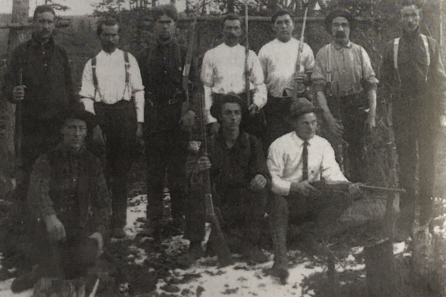
Hunters for the Grand Trunk Pacific Railway at Dome Creek, 1913.
![Surveyors camp at Dome Creek circa 1912 I.B. Guest photo. [Olson 2017 p. 105]](/wp-content/uploads/2025/02/olson-dome-creek.jpg)
Surveyors camp at Dome Creek circa 1912 I.B. Guest photo. [Olson 2017 p. 105]
Named in association with Dome Mountain. The Dome Creek watercourse appears on the 1919 Pre-emptor’s map Tête Jaune Sheet but not the community.
Dome Creek was located 55 miles from McBride and may have reached a population peak of 2000 during construction of the Grand Trunk Pacific Railway‘s “Second Crossing” bridge over the Fraser River just west of the community.
Dome Creek is situated between the Grand Canyon and Goat River, about roughly midway between Prince George and Tête Jaune Cache. The land is beautifully situated on the Fraser River, and commands a magnificent view. During the construction of the Grand Trunk Pacific Railway, Dome Creek was referred to as Mile 142 to Mile 145, Mile 142 being the campsite and Mile 145, where the bridge crosses the Fraser River.
Fort George Herald, March 3rd , 1911: “Another Townsite: A section of land at the mouth of Dome Creek was sold in Vancouver recently to some well known local men who, we are informed, intend to townsite the property.
Fort George Herald, July 22, 1911: The primal necessity for the up-building of the future city of Dome Creek arrived here this week on the steamer B. X. In the shape of an engine for the sawmill that is to be installed there by the Northern Lumber Co. Dome Creek, when put on the market, will be a thriving burg in a hurry. The site is ideally situated in the heart of the timber country, 134 miles up-river from here.
Later issues of the same paper describe the mill as capable of a 35,000 board feet per day output, also a shingle mill and a sash and door factory “right in the choicest of the cedar timber belt.” The mill owner was W.F. Cooke, one of the principals involved in purchasing and developing the townsite.
Fort George Herald, May 1913; The Foley Welch and Stewart boats were launched this week at Dome Creek where they were wintered… and will commence distributing men and supplies in the camps.
— Quoted in Olson
Wrigley’s Directory for 1918:
DOME CREEK: a post office and lumbering settlement at Mile 1190 G.T.P. west at junction of Dome Creek and Fraser River, in Fort George Provincial Electoral District. Nearest station is Bend on the G.T.P. Ry. distant 2 miles, and nearest telegraph G.T.P. at McBride, 55 miles, with local telephones. Population 250. Local resources: Lumbering and homesteading.
Albrecht A ranching
Attoff D mixed farming
Benson O ranching
Brennan Jack ranching
Casler F ranching
Cattle Mrs J W ranching
Conture F ranching
Dayton D ranching
Dayton M ranching
Dome Creek Lumber Co. Ltd. Chas. Neilson, Pres.; A. M. Neilson, Sec’y-treas. Mfrs. Fir and Pine Lumber.
Dufour Jos farming
Gale E T ranching
Hooker ranching
Jensen E W ranching
Johnson Oscar ranching
Johnson Richard D ranching
Kendall Jas O manager Upper Fraser Lumber Co Ltd
Langton F ranching
Logan George ranching
MacNeill Jas A mixed farming
McCIarty Archie ranching and logger
Mainwarning Ed ranching
Neilson A M manager Dome Creek Lumber Co Ltd
Schiescer Jacob ranching
Shernie A ranching
Smith Mrs Lottia ranching
Upper Fraser Lumber Co Ltd J O Kendall mgr mfrs fir & cedar lumber
Webber E L accountant
Westerway & Waldron shingle mill
Wylie R J ranching
The 1922 Wrigley’s lists:
Albright A ranching
Atoff David farming
Benson O ranching
Blaikie Chas mgr Dome Creek Lbr Co Ltd
Brennan Jack E ranching
Brown Sidney D saw-filer
Campbeil Geo teamster
Campbell Jas laborer
Carter F A ranching
Conway J Finlay edgerman
Crassweller Harold J laborer
Dayton Martin prospector
Dome Creek Farmers’ Inst E L Gale sec
Dufour Jos farming
Edward J C ranching
Gale E L ranching and sec Dome Creek Farmers’ Inst
Gordon Wm G R lumberman
Gordy W ranching
Green Percival A bookkeeper
Hooker J B ranching
Jensen E trapper rancher
Jensen E W trapper
Johnson Oscar ranching
Johnson Richard D ranching
Langton F ranching
McClarty Archie farming
McDowell Reginald H scaler
MacNeill Jas A mixed farming
Miller F ranching
Miller Henry farming
Nason Ithiel B laborer
Peterson C W ranching
Reade Wm farming
Robinson Harry sawmill man
Ryan Fred laborer
Schlesser Jacob ranching
Sims Jos W farming
Stewart A laborer
Stewart James ranching pool general store and PM
Strong Leslie H engineer
Thrasher A timekeeper
Tyhunt R I mgr Upper Fraser Lumber Co Ltd
Upper Fraser Lumber Co Ltd R I Tyhunt mgr
Waddell Jas H laborer
Walsh Patrick J engineer
Westerlund H laborer
Wilde Geo H P emp GTP
Wylie R J ranching
Some relation to gold prospecting.
British-born George Middleton Dennison [d. 1943] and Flora Elizabeth Dennison , née MacLaurin [d.1951], ran stopping places for teamsters hauling freight for the construction of the Grand Trunk Pacific Railway and Canadian Northern Railway. They settled in the Mount Robson area around 1910, and were granted a homestead in 1913. With his nephew Harold Britton [d. 1943], George ran a guide and outfitting business until the 1940s. He occasionally worked for guide Jack Brewster out of Jasper.
George Dennison was a major in the British calvary during the Boer War. He was presented to King George VI and Queen Elizabeth during the royal stop at Mount Robson in 1939. George died in 1943 when he was hit by a train while on guard duty at the Japanese internment camp. He is buried at Mount Robson. Florence died in 1951 at Surrey, British Columbia.
The original automobile road from Tête Jaune Cache to Jasper followed the old railway tote road as far as Moose Lake, and then followed the abandoned Canadian Northern Railway grade to Jasper. According to Tom Carr, “There were two hills between Mount Robson and the Pass that took some doing to get up in any kind of adverse weather, because of the steep grade, crooked road, and dirt base. The first hill was directly in front of Dennison’s property. Because of the trouble it caused travelers by car, it warranted a name other than *&!%$!@. More politely it became known as Dennison Hill.” When the Yellowhead Highway was being built a gravel pit was opened on the top of Dennison hill.
In September 1911, as construction of the railroad’s tote road approached Tête Jaune Cache, two young American adventurers, A. C. Jennison and D.C. Adams, freighted a canoe through the Yellowhead Pass to Resplendent. They canoed down the Fraser River until they reached the box canyon above Tête Jaune Cache, where their canoe capsized in an eddy and they both drowned. Weeks later their bodies were found, one of them at the point of this island a few miles below the Cache.
Herbert C. (1892–1958) and Ethel G. (1896–1981) Dawson moved to a homestead between Dunster and Shere in the 1930s, after a spell of dry years in Saskatchewan. Herb worked on the railroad, homesteaded, and farmed. They raised six children, their youngest born at Lucerne (CNoR railway point) in 1924. During the 1930s Dawson took his team and wagon to Small Creek to work on the new highway being built from Tête Jaune Cache to Lamming Mills.