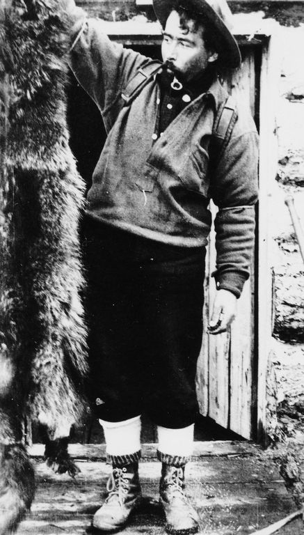
Category Archives: Place

McBride Community Park

British Columbia. Former name
Former park on N side of Doré River on Museum Road
53.3333 N 120.2 W — Map 093H08 — GoogleGeoHack
Name officially adopted in 1955
Not currently an official name

Established as a Class C provincial park primarily for the use and enjoyment of local residents in 1955.

In June 1969, Helena Lonsdale, secretary of the McBride Community Park, wrote a letter to the editor urging development of the park for the tourists expected as the highway to Prince George neared completion. Help at a clean-up day included George Monroe, 84, who split firewood.

Provincial status was cancelled in February 1976 and transferred to the village of McBride. The park was discontinued in the 1980s as it was being used as a late-night party venue.

References:

  • Robson Valley Courier. Weekly newspaper published by Pyramid Press of Jasper from 1968–88 (1968–1988).

McBride

British Columbia. Village: Fraser River drainage
On Fraser River 140 km west of Yellowhead Pass
53.3042 N 120.1639 W — Map 093H08 — GoogleGeoHack
Earliest known reference to this name is 1911 (GTP map)
Name officially adopted in 1965
Official in BCCanada
90 miles west of the Yellowhead Pass on the Canadian National Railway
Mile 63 in Tete Jaune Subdivision (Red Pass to McBride as of 1977)
Mile 0 in Fraser Subdivision (McBride to Prince George as of 1977)
Grand Trunk Pacific Railway station built in 1913. Rebuilt in 1919
Sir Richard McBride

Sir Richard McBride
Wikipedia


“The first townsite laid out on the Grand Trunk Pacific Railway in this district is McBride (Mile 90), which will be a divisional point. Yards have been laid out here on a large scale and the construction of shops and a roundhouse is well under way. The town which will arise here will probably contain the first post-office, and being in the heart of the best agricultural land will no doubt become a general centre.” — Morkill, South fork of the Fraser, 1913

In 1910, when Louie Knutson first came through what is now the village of McBride, it was known as the Flats. In 1911 surveyors chose as a townsite and divisional point Mile 90, where the valley opened up into a wide flat area with an ample water supply. They named the new town after the premier of British Columbia, Richard McBride (1870-1917).

The McBride post office opened in February 1914.

Richard McBride’s government chartered a new railway, the Grand Trunk Pacific, but the government did not initially grant a subsidy. Later it did make certain grants which lead to cries of corruption and a demand for investigation. After winning another election in 1907, McBride went off to England, where Lord Grey observed, “I like the look of that picturesque buffalo, McBride.” For his labours on behalf of the province, his ardent support of the Conservative party, his promotion of the imperial connection, his championing of the navy and for the loyal support he gave the federal Prime Minister, Robert Borden recommended to the Governor-General that McBride be invested with the Order of the Knight, Commander of St. Michael and St. George.

McBride’s most famous decision was the acquisition of two Seattle-built submarines in early August 1914, just before American neutrality laws came into effect. “The people’s Dick” beat Uncle Sam to the draw. A few days later the submarines were taken over by the Dominion government.

McBride settled in London, Englnd, where he became agent-general for British Columbia. Health declining, he resigned his post on 20 May 1917, hoping to return to his native province. He died on 6 August 1917, at age 47.

References:

  • Morkill, Dalby Brooks [1880–1955]. “Report on Survey on the South Fork of Fraser River from Horse Creek to Beaver River. December 28, 1912.” Report of the Minister of Lands for the Province of British Columbia for the year ending 31st December 1912, (1913):238-240. Google Books
  • Walker, James Alexander [1887–1959]. “South fork of Fraser River, vicinity of McBride. November 11, 1914.” Report of the Minister of Lands for the Province of British Columbia for the Year Ending 31st December 1914, (1915). Google Books
  • Lower, Joseph Arthur. The Grand Trunk Pacific Railway and British Columbia (thesis). University of British Columbia, 1939. University of British Columbia Library
  • Jackman, S. W. Portraits of the premiers: An informal history of British Columbia. Sidney, B.C.: Grey’s Publishing, 1969
  • Wheeler, Marilyn [1932–2016]. The Robson Valley Story. McBride, B.C.: Robson Valley Story Group, 1979
  • Wikipedia. Richard McBride

Mazama Creek

British Columbia. Former name: Columbia River drainage
Former name for Hugh Allan Creek
52.45 N 118.6667 W GoogleGeoHack
Earliest known reference to this name is 1923 (Phillips)
Not currently an official name.
This former name appears on:
Boundary Commission Sheet 27 (surveyed in 1920 & 1921) [Former name of Hugh Allen Creek]

Describing the pass at the head of Whirlpool River, Donald “Curly” Phillips [1884–1938] wrote, “Crossed by Phillips’ party from Whirlpool River to Mazama Creek (Goat River)” (not the current Goat River).

References:

  • Phillips, Donald “Curly” [1884–1938]. “Athabaska Pass to Tonquin Valley via Goat and Fraser Rivers.” Canadian Alpine Journal, Vol. 13 (1923):153

Mastodon Peak

British Columbia. Peak
Previous name of Mastodon Mountain
52.6167 N 118.35 W — Map 83D/9 — GoogleGeoHack
Earliest known reference to this name is 1922 (Wheeler and Cautley)
Name officially adopted in 1963
Not currently an official name

Named in 1922 by the Alberta-British Columbia Boundary Commission survey party because of a resemblance to the extinct form of elephant.

“Mastodon Peak” adopted in 1924, derived from “Mount Mastodon” as indicated on Boundary Commission sheet 28, surveyed in 1921. Form of name changed to “Mastodon Mountain” in 1962 by Alberta and 1963 by British Columbia.

References:

  • Cautley, Richard William [1873–1953], and Wheeler, Arthur Oliver [1860–1945]. Report of the Commission appointed to delimit the boundary between the Provinces of Alberta and British Columbia. Part II. 1917 to 1921. From Kicking Horse Pass to Yellowhead Pass.. Ottawa: Office of the Surveyor General, 1924. Whyte Museum
  • Cautley, Richard William [1873–1953], and Wheeler, Arthur Oliver [1860–1945]. Report of the Commission Appointed to Delimit the Boundary between the Provinces of Alberta and British Columbia. Parts IIIA & IIIB, 1918 to 1924. From Yellowhead Pass Northerly. Ottawa: Office of the Surveyor General, 1925. Whyte Museum
  • Holmgren, Eric J., and Holmgren, Patricia M. Over 2,000 place names of Alberta. Saskatoon, Saskatchewan: Modern Press, 1973. Internet Archive
Also see:

Martinson Creek

British Columbia. Creek: Fraser River drainage
Flows NW into Doré River
53.2986 N 120.26 W — Map 093H08 — GoogleGeoHack
Name officially adopted in 1965
Official in BCTopo map from Canadian Geographical Names
The 1918 Wrigley’s British Columbia Directory lists “Martinson I mixed farming” under McBride, and “Martinson, Mentz farming” under Rooney.
References:

  • Wrigley Directories, Limited. Wrigley’s British Columbia Directory. Vancouver: 1918, p. 271. Internet Archive [accessed 6 February 2025]

Manteau Creek

British Columbia. Creek: North Thompson River drainage
Flown NE into North Thompson River W of Gosnell (railway point)
52.5083 N 119.3972 W — Map 83D/11 — GoogleGeoHack
Name officially adopted in 1962
Official in BCCanada
This creek appears on:
Zillmer maps of Cariboo 1939-1948 [1947]

“Manteau” is French for a coat or blanket. What its significance is in this case is unknown.

Malton Range

British Columbia. Range
W of Canoe River, E of Albreda Riverand North Thompson River
52.6333 N 119.0667 W — Map 83D/11 — GoogleGeoHack
Name officially adopted in 1961
Official in BCCanada
This range appears on:
Milton and Cheadle’s map 1865

Although this range was not mentioned in Milton and Cheadle’s published account, it appears on the map accompanying the report of their trip from Saskatchewan to British Columbia in 1863-64. Malton is a village in Yorkshire. Milton’s father, William Wentworth-FitzWilliam, 6th Earl FitzWilliam, was member of parliament for Malton from 1837 to 1841. One of Fitzwilliam’s seats, “The Lodge,” was situated at Malton.

References:

  • Milton, William Wentworth Fitzwilliam [1839–1877], and Cheadle, Walter Butler [1835–1910]. The North-West Passage by Land. Being the narrative of an expedition from the Atlantic to the Pacific, undertaken with the view of exploring a route across the continent to British Columbia through British territory, by one of the northern passes in the Rocky Mountains. London: Cassell, Petter and Galpin, 1865. Internet Archive
  • White, James [1863–1928]. “Place names in the vicinity of Yellowhead Pass.” Canadian Alpine Journal, Vol. 6 (1914–1915):107-114

Main Street

Feature type: street
Province: British Columbia
Location: McBride
Latitude: 53.3011 N
Longitude: 120.1695 W
Google Maps

“The towns fringing the Grand Trunk Pacific, which on the average are spaced about eight miles apart, are all located on the northern side of the line, with one or two exceptions. The principal thoroughfare striking directly from the station is always the Main Street, and is generally known as such. It is a noble highway 80 feet in width, which provides a 60 foot roadway.” So wrote Frederick Talbot in his book written for the Grand Trunk Pacific Railway in 1912.

References:

  • Talbot, Frederick Arthur Ambrose [1880–1924]. The making of a great Canadian railway. The story of the search for and discovery of the route, and the construction of the nearly completed Grand Trunk Pacific Railway from the Atlantic to the Pacific with some account of the hardships and stirring adventures of its constructors in unexplored country. London: Seely, 1912. Internet Archive
Also see: