Tag Archives: boundary survey

Mastodon Mountain

Alberta-BC boundary. Mountain
S of Mount Fraser
52.6072 N 118.3344 W — Map 083D09 — GoogleGeoHack
Name officially adopted in 1963
Official in BCCanada
This mountain appears on:
Boundary Commission Sheet 28 (surveyed in 1921) [as “Mount Mastodon”]

“Mastodon Peak” adopted in 1924, derived from name on BC-Alberta Boundary sheet 28, 1921. Form of name changed to “Mastodon Mountain” in 1962 by Alberta and 1963 by British Columbia.

Named in 1922 by the Alberta-British Columbia Boundary Commission survey party because of a resemblance to the extinct form of elephant.

References:

  • Cautley, Richard William [1873–1953], and Wheeler, Arthur Oliver [1860–1945]. Report of the Commission appointed to delimit the boundary between the Provinces of Alberta and British Columbia. Part II. 1917 to 1921. From Kicking Horse Pass to Yellowhead Pass.. Ottawa: Office of the Surveyor General, 1924. Whyte Museum
  • Cautley, Richard William [1873–1953], and Wheeler, Arthur Oliver [1860–1945]. Report of the Commission Appointed to Delimit the Boundary between the Provinces of Alberta and British Columbia. Parts IIIA & IIIB, 1918 to 1924. From Yellowhead Pass Northerly. Ottawa: Office of the Surveyor General, 1925. Whyte Museum

Yellowhead Pass

Alberta-BC boundary. Pass
Athabasca River and Fraser River drainages
Between Fraser River and Miette River
52.8925 N 118.4639 W — Map 83D/16 — GoogleGeoHack
Earliest known reference to this name is 1859 (Arrowsmith)
Name officially adopted in 1951
Official in BCCanada
The Yellowhead Pass. Sir Sandford Fleming, based on an expedition in 1872

The Yellowhead Pass. Sir Sandford Fleming, based on an expedition in 1872
Alpine Club of Canada


On the Yellowhead Pass.
Photo: Mary Schaffer, 1908

On the Yellowhead Pass.
Photo: Mary Schaffer, 1908
Whyte Museum of the Canadian Rockies


Sunset on the Yellow Head Pass. 
Photo: Dr. J. Norman Collie, 1910

Sunset on the Yellow Head Pass.
Photo: Dr. J. Norman Collie, 1910
Alpine Journal 1912


Monument placed at summit of Yellowhead Pass.
Photo: A. 0. Wheeler, 1911

Monument placed at summit of Yellowhead Pass.
Photo: A. 0. Wheeler, 1911
Canadian Alpine Journal 1912

Appears as “Yellow Head Pass” on Hanington’s map.

“Tête Jaune Cache is some fifty miles down on the west side from the summit of Yellowhead Pass, not far from the junction of the North or Grand fork with the southerly branch of Fraser River. It was so named from the fact that an Iroquois trapper known as “Tête Jaune” or “Yellow Head,” made this cache the receptacle for his catch of fur. He seems to have been a man of some celebrity in the neighborhood for, presumably, the pass has been named after him.”
— Arthur Wheeler

Tête Jaune” was the nickname of Pierre Bostonais [d. 1827], a guide of Iroquois extraction who worked for the North West Company and Hudson’s Bay Company . In 1825, he guided the first party recorded to cross this pass. From 1826 until the 1850s, the pass was occasionally used by the Hudson’s Bay Company to transport leather from the Saskatchewan District to New Caledonia. Despite its low elevation — at 1,131 metres second only to the Monkman Pass in the Canadian Rockies — and its mildly inclined approaches, it was used only sporadically during the fur trade. The route over the Yellowhead Pass stretched, without intervening posts, for more than 600 km between Jasper House, on the Athabasca River, to Fort George, on the Fraser. “The lengthy and uninterrupted isolation imposed on the brigades along the route, the unreliable navigability of the Athabasca and Fraser rivers, and the unpredictable weather of the usual mid-autumn journey presented problems,” according to historian David Smythe.

“It was also used to some extent by the Rocky Mountain Indians of the Shuswap tribe on the journey from Kamloops via Thompson River to Athabasca River at Jasper House, where, presumably, they carried on trade with the fur company,” according to Arthur Oliver Wheeler [1860–1945], who surveyed the pass in 1917 for the commission appointed to delimit the boundary between the provinces of Alberta and British Columbia.

The fur traders who used this pass in the first half of the nineteenth century never called it, or any other mountain pass, a pass. They called it a portage. Infrequently called the New Caledonia portage in the letters and journals of the period, the Yellowhead Pass was almost exclusively referred to as the route or portage via Tête Jaune Cache. On a few occasions in the 1820s, the officer in charge of New Caledonia referred to the route as “the Leather track,” encompassing the entire distance between Fort George and Jasper House. After 1860, the pass was also briefly known as the Cowdung Pass, after an early name of Yellowhead Lake. It was also referred to at various times as Leatherhead Pass, Jasper and Jasper House Pass, Tête Jaune and Tête Jaune Cache Pass, Myette Pass, and even the Rocky Mountain Pass. The actual name “Yellowhead” appears to have first been used on the Arrowsmith 1859 map.

Sir Sandford Fleming crossed the pass in 1872, reconnoitering a route for the Canadian Pacific Railway:

A few minutes afterwards the sound of a rivulet running in the opposite direction over a red pebbly bottom was heard. Thus we left the Myette flowing to the Arctic ocean, and now came upon this, the source of the Fraser, hurrying to the Pacific. At the summit Moberly welcomed us into British Columbia, for we were at length out of “No man’s land,” and had entered the western province of our Dominion [B.C. became a Canadian province in 1871]. Round the rivulet running west the party gathered and drank from its waters to the Queen and the Dominion. Where had been little or no frost near the summit, and flowers were in bloom that we had seen a month ago farther east. Before encamping for the night we continued our journey some twenty-six miles farther into British Columbia, well satisfied that no incline could be more gentle than the trail we had followed to the Pacific slope through the Yellow Head pass.

“It was originally selected as the route of the Canadian Pacific Railway but was later abandoned,” Wheeler noted. “Now it is crossed by two other transcontinental lines of the Canadian National Railways.”

References:

  • Arrowsmith, John [1790–1873]. Provinces of British Columbia and Vancouver Island; with portions of the United States and Hudson’s Bay Territories. 1859. UVic
  • Trutch, Joseph William [1826–1904]. Map of British Columbia to the 56th Parallel North Latitude. Victoria, B.C.: Lands and Works Office, 1871. University of Victoria
  • McEvoy, James [1862–1935]. “Map Showing Yellowhead Pass Route From Edmonton To Tête-Jaune Cache.” (1900). Natural Resources Canada
  • Fleming, Sandford [1827–1915]. “Memories of the Mountains: The Yellow Head Pass.” Canadian Alpine Journal, Vol. 1 (1907):11
  • Schäffer Warren, Mary T. S. [1861–1939]. Old Indian trails. Incidents of camp and trail life, covering two years’ exploration through the Rocky Mountains of Canada. [1907 and 1908]. New York: Putnam, 1911, p. 339. Internet Archive
  • Wheeler, Arthur Oliver [1860–1945]. “The Alpine Club of Canada’s expedition to Jasper Park, Yellowhead Pass and Mount Robson region, 1911.” Canadian Alpine Journal, Vol. 4 (1912):9-80
  • Collie, John Norman [1859–1942]. “On the Canadian Rocky Mountains north of the Yellowhead Pass.” Alpine Journal, Vol. 26 (1912):5-17
  • Cautley, Richard William [1873–1953], and Wheeler, Arthur Oliver [1860–1945]. Report of the Commission appointed to delimit the boundary between the Provinces of Alberta and British Columbia. Part II. 1917 to 1921. From Kicking Horse Pass to Yellowhead Pass.. Ottawa: Office of the Surveyor General, 1924. Whyte Museum
  • Smyth, David. “Some fur trade place names of the Yellowhead Pass: west of the summit to Tête Jaune Cache.” Canoma (journal of the Canadian Permanent Committee on Geographical Names), Vol. 11, No. 2 (1985)

Tête Roche

British Columbia. Mountain
N of Yellowhead Lake
52.9 N 118.5667 W — Map 083D15 — GoogleGeoHack
Name officially adopted in 1924
Official in BCCanada

The site of a camera station on the Alberta-British Columbia Boundary Commission survey, which worked through Yellowhead Pass in 1917. Presumably named to recall Pierre Bostonais dit “Tête Jaune” [d. 1827].

References:

  • Canadian Board on Geographical Names. Place-names of Alberta. Published for the Geographic Board by the Department of the Interior. Ottawa: Department of the Interior, 1928. Hathi Trust
  • Wheeler, Marilyn [1932–2016]. The Robson Valley Story. McBride, B.C.: Robson Valley Story Group, 1979
Also see:

Mount McNaughton

British Columbia. Mount
NE of Moose Lake, SW of Salient Mountain
53.0167 N 118.75 W — Map 83E/2 — GoogleGeoHack
Name officially adopted in 1923
Official in BCCanada
Margaret McNaughton

Margaret McNaughton
Overland to Cariboo

Named by Alberta-British Columbia Boundary Commission surveyors after Margaret McNaughton [1856–1915], author of Overland to Cariboo, an account of an overland journey by 150 pioneers and goldseekers, from Fort Garry to the goldfields of British Columbia in 1862, published in Toronto, 1896.

Archibald McNaughton [1843-1900] was the youngest of the Overlanders who trekked from eastern Canada to the Cariboo gold fields in 1862. McNaughton was born and educated in Montreal. After arriving in the Cariboo in 1862, he spent several years in mining and several more in commerce. In 1884 McNaughton was appointed assessor and collector for the district of Cariboo. Later that year he entered the employ of the Hudson’s Bay Company. In 1885, the year he married his cousin Elizabeth McGregor (d. 1887) of Montreal, he was promoted to manager for the Cariboo for the Hudson’s Bay Company, a position which he held until his paralysis in 1894. In 1887 he was appointed postmaster for Quesnel. In 1888 he married Scottish-born Margaret Pebbles, who recorded his cross-country journey in her book, Overland to Cariboo.

References:

  • McNaughton, Margaret [1856–1915]. Overland to Cariboo: An eventful journey of Canadian Pioneers to the gold fields of British Columbia in 1862. Toronto: Willliam Briggs, 1896. Internet Archive
  • Wikipedia. Margaret McNaughton
  • British Columbia Geographical Names. McNaughton, Mount

Mastodon Peak

British Columbia. Peak
Previous name of Mastodon Mountain
52.6167 N 118.35 W — Map 83D/9 — GoogleGeoHack
Earliest known reference to this name is 1922 (Wheeler and Cautley)
Name officially adopted in 1963
Not currently an official name

Named in 1922 by the Alberta-British Columbia Boundary Commission survey party because of a resemblance to the extinct form of elephant.

“Mastodon Peak” adopted in 1924, derived from “Mount Mastodon” as indicated on Boundary Commission sheet 28, surveyed in 1921. Form of name changed to “Mastodon Mountain” in 1962 by Alberta and 1963 by British Columbia.

References:

  • Cautley, Richard William [1873–1953], and Wheeler, Arthur Oliver [1860–1945]. Report of the Commission appointed to delimit the boundary between the Provinces of Alberta and British Columbia. Part II. 1917 to 1921. From Kicking Horse Pass to Yellowhead Pass.. Ottawa: Office of the Surveyor General, 1924. Whyte Museum
  • Cautley, Richard William [1873–1953], and Wheeler, Arthur Oliver [1860–1945]. Report of the Commission Appointed to Delimit the Boundary between the Provinces of Alberta and British Columbia. Parts IIIA & IIIB, 1918 to 1924. From Yellowhead Pass Northerly. Ottawa: Office of the Surveyor General, 1925. Whyte Museum
  • Holmgren, Eric J., and Holmgren, Patricia M. Over 2,000 place names of Alberta. Saskatoon, Saskatchewan: Modern Press, 1973. Internet Archive
Also see:

Loren Lake

British Columbia. Lake: Fraser River drainage
Headwaters of Chalco Creek near Alberta-British Columbia Boundary
53.4833 N 119.85 W — Map 83E/5 — GoogleGeoHack
Name officially adopted in 1925
Official in BCCanada

Origin of the name unknown.

References:

  • Interprovincial Boundary Commission. 
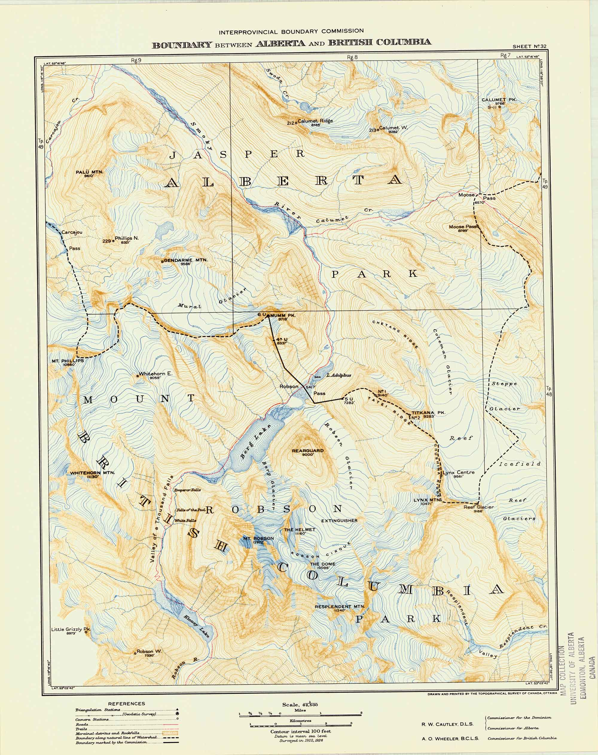
Boundary between Alberta and British Columbia. Sheet 36. Ottawa: Office of the Surveyor General, 1924. Internet Archive
Also see:

Elephas Mountain

Alberta-BC boundary. Mountain
E of headwaters of Fraser River
52.5967 N 118.3297 W — Map 083D09 — GoogleGeoHack
Name officially adopted in 1924
Official in BCCanada
This mountain appears on:
Boundary Commission Sheet 28 (surveyed in 1921) [as “Mt. Elephas”]

The feature was named by the Alberta-British Columbia Boundary Commission in 1921.

Although there is no doubt that this peak was named by the Boundary Survey from the fact that is adjacent to Mt. Mastodon, and not from any actual resemblance to the animal in question, it is a singular coincidence that as seen from our bivouac, the mountain forms a perfect elephant, trunk, ears and eyes complete.

— C. G. Wates, first ascent of Mount Elephas, 1933
References:

  • Cautley, Richard William [1873–1953], and Wheeler, Arthur Oliver [1860–1945]. Report of the Commission appointed to delimit the boundary between the Provinces of Alberta and British Columbia. Part II. 1917 to 1921. From Kicking Horse Pass to Yellowhead Pass.. Ottawa: Office of the Surveyor General, 1924. Whyte Museum
  • Cautley, Richard William [1873–1953], and Wheeler, Arthur Oliver [1860–1945]. Report of the Commission Appointed to Delimit the Boundary between the Provinces of Alberta and British Columbia. Parts IIIA & IIIB, 1918 to 1924. From Yellowhead Pass Northerly. Ottawa: Office of the Surveyor General, 1925. Whyte Museum
  • Wates, Cyril G. [1883–1946]. “The Eremite and beyond.” Canadian Alpine Journal, Vol. 22 (1933):64-70
Also see:

Blackrock Mountain

Alberta-BC boundary. Mountain
Headwaters of Fraser River
52.5714 N 118.2997 W — Map 083D09 — GoogleGeoHack
Name officially adopted in 1924
Official in BCCanada
This mountain appears on:
Boundary Commission Sheet 28 (surveyed in 1921) [as “Mt. Blackrock””]

The feature was named by the Alberta-British Columbia Boundary Commission in 1921, labelled as “Mount Blackrock” on BC-Alberta boundary sheet 28, 1921. Descriptive of the sharp black peak.

References:

  • Cautley, Richard William [1873–1953], and Wheeler, Arthur Oliver [1860–1945]. Report of the Commission appointed to delimit the boundary between the Provinces of Alberta and British Columbia. Part II. 1917 to 1921. From Kicking Horse Pass to Yellowhead Pass.. Ottawa: Office of the Surveyor General, 1924. Whyte Museum
  • Cautley, Richard William [1873–1953], and Wheeler, Arthur Oliver [1860–1945]. Report of the Commission Appointed to Delimit the Boundary between the Provinces of Alberta and British Columbia. Parts IIIA & IIIB, 1918 to 1924. From Yellowhead Pass Northerly. Ottawa: Office of the Surveyor General, 1925. Whyte Museum
  • British Columbia Geographical Names. Blackrock Mountain