Monthly Archives: March 2014

Elephas Mountain

Alberta-BC boundary. Mountain
E of headwaters of Fraser River
52.5967 N 118.3297 W — Map 083D09 — GoogleGeoHack
Name officially adopted in 1924
Official in BCCanada
This mountain appears on:
Boundary Commission Sheet 28 (surveyed in 1921) [as “Mt. Elephas”]

The feature was named by the Alberta-British Columbia Boundary Commission in 1921.

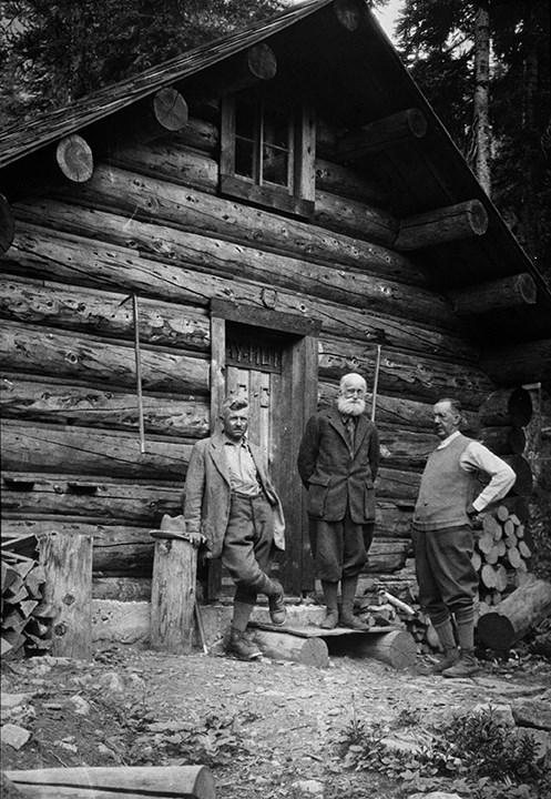
Although there is no doubt that this peak was named by the Boundary Survey from the fact that is adjacent to Mt. Mastodon, and not from any actual resemblance to the animal in question, it is a singular coincidence that as seen from our bivouac, the mountain forms a perfect elephant, trunk, ears and eyes complete.

— C. G. Wates, first ascent of Mount Elephas, 1933
References:

  • Cautley, Richard William [1873–1953], and Wheeler, Arthur Oliver [1860–1945]. Report of the Commission appointed to delimit the boundary between the Provinces of Alberta and British Columbia. Part II. 1917 to 1921. From Kicking Horse Pass to Yellowhead Pass.. Ottawa: Office of the Surveyor General, 1924. Whyte Museum
  • Cautley, Richard William [1873–1953], and Wheeler, Arthur Oliver [1860–1945]. Report of the Commission Appointed to Delimit the Boundary between the Provinces of Alberta and British Columbia. Parts IIIA & IIIB, 1918 to 1924. From Yellowhead Pass Northerly. Ottawa: Office of the Surveyor General, 1925. Whyte Museum
  • Wates, Cyril G. [1883–1946]. “The Eremite and beyond.” Canadian Alpine Journal, Vol. 22 (1933):64-70
Also see:

Edwards Road

British Columbia. Road
Joins Highway 16 near Legrand, w of McBride
53.3989 N 120.400 W GoogleGeoHack
Roads are not in the official geographical names databases

Harold Edwards owns the property at the end of the road. The portion of the road between the highway and the railway is also known as Legrand Access Road.

Edward Peak

Alberta. Mount
Approximately 135 km NW of Banff
51.9594 N 117.095 W GoogleGeoHack
Name officially adopted in 1972
Official in Canada
Edward Feuz Jr., Professor Charles Ernest Fay and Dr. Hickson standing in front of Fay Hut. August 1930.

Edward Feuz Jr., Professor Charles Ernest Fay and Dr. Hickson standing in front of Fay Hut. August 1930.
Whyte Museum of the Canadian Rockies

One of the peaks of Mount Lyell, named for guide Edward Feuz Jr. (1884-1981), a Canadian Pacific Railway mountain guide. Feuz was the son of one of the first Swiss Guides brought to Canada by the railway. He climbed at Field and Glacier House in 1903 with his father and guided during summers from 1905 to 1912, settling that year in the Edelweiss Village at Golden, British Columbia.

Until his retirement in the 1950s, he accompanied the finest climbers and was involved in over seventy first ascents of peaks over 3048 metres.

References:

  • Karamitsanis, Aphrodite [1961–]. Place names of Alberta. Volume 1: Mountains, Mountain Parks and Foothills. Calgary: University of Calgary Press, 1991
Also see:

Eddy Creek

British Columbia. Creek: Fraser River drainage
Flows NE into Fraser SE of McBride
53.2508 N 120.1081 W — Map 093H01 — GoogleGeoHack
Name officially adopted in 1965
Official in BCCanada

An eddy is a circular motion in water, a small whirlpool.

The Eddy Post Office was open from 1945 to 1947.

References:

  • Topping, William. A checklist of British Columbia post offices. Vancouver: published by the author, 7430 Angus Drive, 1983
Also see:

Eddy

British Columbia. Locality
On Canadian National Railway SE of McBride, between Eddy Creek and Raush Valley (railway point)
53.2364 N 120.0692 W — Map 093H01 — GoogleGeoHack
Earliest known reference to this name is 1911 (GTP map)
Name officially adopted in 1983
Official in BCCanada
83 miles west of the Yellowhead Pass on the Canadian National Railway
Mile 57 in Tete Jaune Subdivision (Red Pass to McBride as of 1977)
Grand Trunk Pacific Railway station built in 1913
Eddy Station, 1947.

Eddy Station, 1947.
Robert Frear

Site of a Grand Trunk Pacific Railway station (Mile 83) between Raush Valley and McBride.

In 1918 Eddy had three settlers, according to Wrigley’s Directory,  dwindling to only a section crew by 1928.  In the late 1930s it blossomed into a sawmill community until the late 1960s.

The Eddy Post Office was open from 1945 to 1947.

I remember this station was still standing in about ’63, but the CNR burned it down shortly thereafter.

References:

  • Wrigley Directories, Limited. Wrigley’s British Columbia Directory. Vancouver: 1918. Internet Archive
Also see:

Dunster

British Columbia. Community
On Canadian National Railway, S of junction of Fraser River and Raush River
53.1242 N 119.8378 W — Map 083E04 — GoogleGeoHack
Earliest known reference to this name is 1914 (Grand Trunk Pacific timetable)
Name officially adopted in 1982
Official in BCCanada
70 miles west of the Yellowhead Pass on the Canadian National Railway
Mile 43 in Tete Jaune Subdivision (Red Pass to McBride as of 1977)
Grand Trunk Pacific Railway station built in 1913. Now a museum

Grand Trunk Pacific railway station at Dunster (Mile 70) was named by a railway inspector after Dunster, his home village in Somerset, England. The Dunster post office opened in 1915.

References:

  • Wheeler, Marilyn. The Robson Valley Story. McBride, B.C.: Robson Valley Story Group, 1979
  • Topping, William. A checklist of British Columbia post offices. Vancouver: published by the author, 7430 Angus Drive, 1983

Dungeon Peak

Alberta-BC boundary. Peak
Near headwaters Geikie Creek
52.6864 N 118.2958 W — Map 083D09 — GoogleGeoHackBivouac
Name officially adopted in 1951
Official in BCCanada
Elevation: 3129 m

This feature was named by the Alberta-British Columbia Boundary Commission in 1921. One of The Ramparts.

References:

  • Cautley, Richard William [1873–1953], and Wheeler, Arthur Oliver [1860–1945]. Report of the Commission appointed to delimit the boundary between the Provinces of Alberta and British Columbia. Part II. 1917 to 1921. From Kicking Horse Pass to Yellowhead Pass.. Ottawa: Office of the Surveyor General, 1924. Whyte Museum
  • Cautley, Richard William [1873–1953], and Wheeler, Arthur Oliver [1860–1945]. Report of the Commission Appointed to Delimit the Boundary between the Provinces of Alberta and British Columbia. Parts IIIA & IIIB, 1918 to 1924. From Yellowhead Pass Northerly. Ottawa: Office of the Surveyor General, 1925. Whyte Museum
Also see: