Category Archives: Place

Hugh Allan Creek

British Columbia. Creek: Columbia River drainage
Flows NW into Canoe Reach, Kinbasket Lake
52.45 N 118.6667 W — Map 83D/7 — GoogleGeoHack
Name officially adopted in 1974
Official in BCCanada

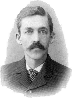
Hugh Drummond Allan [1887–1917] was born in Scotland and came to Canada around 1907. He became a British Columbia land surveyor in 1912. His professional work was carried on mainly in the Kamloops district and the North Thompson valley. In 1913 he surveyed in the Canoe River area. “From Mile 49 on the Grand Trunk Pacific I proceeded with my party by wagon and reached the Canoe River in one day,” he reported.

After the start of the first World War Allan returned to Scotland and enlisted. In 1916 he was wounded, and in 1917 he was killed leading his company at Croiselles, France. Lieutenant Allan was shortly predeceased by his wife and infant child.

(There is another Hugh Allan [1810-1882], a Scottish-Canadian shipping magnate, apparently unrelated.)

References:

  • Allan, Hugh Drummond [1887–1917]. “Canoe River Valley.” Report of the Minister of Lands, (1914)
  • Corporation of Land Surveyors of the Province of British Columbia. Annual Reports (1956)., 1956
  • Andrews, Gerald Smedley [1903–2005]. Métis outpost. Memoirs of the first schoolmaster at the Métis settlement of Kelly Lake, B.C. 1923-1925. Victoria: G.S. Andrews, 1985

Horsey Creek

British Columbia. Creek: Fraser River drainage
Flows SW into Fraser River, NW of Croydon
53.1 N 119.7333 W — Map 83E/4 — GoogleGeoHack
Earliest known reference to this name is 1909 (Washburn)
Name officially adopted in 1963
Official in BCCanada

The name was known to Stanley Washburn in 1909, among those names “given by the trappers.”

References:

  • Washburn, Stanley [1878–1950]. Trails, Trappers and Tenderfeet in the New Empire of Western Canada. New York and London: Henry Holt, Andrew Melrose, 1912. Hathi Trust

Horseshoe Lake

British Columbia. Lake: Fraser River drainage
S of McBride
53.2878 N 120.1508 W — Map 093H08 — GoogleGeoHack
Name officially adopted in 1965
Official in BCCanada
Horseshoe Lake. Village of McBride top left, loop of Fraser River top right, railroad diagonally at the west edge of town

Horseshoe Lake. Village of McBride top left, loop of Fraser River top right, railroad diagonally at the west edge of town
Canadian Geographical Names Database

One of the 100 Horseshoe Lakes in Canada.

Surveyor James Alexander Walker [1887–1959] reported in 1914 that the lake was “very popular in summer for boating and bathing.” The townsite had just been laid out the year before by the Grand Trunk Pacific Railway.

References:

  • Walker, James Alexander [1887–1959]. “South fork of Fraser River, vicinity of McBride. November 11, 1914.” Report of the Minister of Lands for the Province of British Columbia for the Year Ending 31st December 1914, (1915). Google Books
Also see:

Holy Cross Mountain

British Columbia. Mountain
E side of Fraser River overlooking Dome Creek
53.7667 N 120.8 W — Map 93H/15 — GoogleGeoHack
Earliest known reference to this name is 1916
Name officially adopted in 1965
Official in BCCanada

Adopted in 1965 as labelled on BC Lands’ map 1G, 1916. Origin/significance not recorded.

References:

Holways Peak

British Columbia. Former unofficial name
Penny Mountain
Not currently an official name.
This former unofficial name appears on:
W. A. D. Munday’s map Cariboos 1925 [now Penny Mountain]
Edward Willet Dorland Holway

Edward Willet Dorland Holway

Wikitree

Between 1914 and 1916, Edward Willet Dorland Holway [1853–1923] of the University of Minnesota, with Andrew James Gilmour of New York, explored the southern Selkirks, the region about Mount Edith Cavell, the area north of Whitehorn Mountain, and the Cariboo Mountains near Tête Jaune Cache. Theirs was the first mountaineering expedition into the Cariboos, but continuous bad weather prevented any serious climbing.

Holways Peak was renamed “Penny Mountain” in the Premier Range proclamation.

References:

  • Holway, Edward Willet Dorland [1853–1923]. “The Cariboo Mountains.” Canadian Alpine Journal, 8 (1917):36-39
  • Palmer, Howard [1883–1944]. Edward W.D. Holway. A pioneer of the Canadian Alps. Minneapolis: University of Minnesota Press, 1931. Google Books
  • Zillmer, Raymond T. [1887–1960]. “Explorations in the Southern Cariboos.” Canadian Alpine Journal, Vol. 27 (1939):48-61
  • Zillmer, Raymond T. [1887–1960]. “The exploration of the Cariboo Range from the east.” American Alpine Journal, 5:2 (1944):261-274. American Alpine Club
  • Dearness, John. “E. W. D. Holway 1853–1923.” Mycologia, 38 (1946):115-230. Mycologia
  • Edward Willet Dorland Holway (1853 – 1923). 2022 WkikiGTree. WkikiGTree

Holmes River

British Columbia. River: Fraser River drainage
Flows SW into Fraser River, SE of McBride
53.25 N 120.0667 W — Map 93H/8 — GoogleGeoHack
Earliest known reference to this name is 1912 (Walker)
Name officially adopted in 1925
Official in BCTopo map from Canadian Geographical Names

This river was known as Beaver River earlier than 1910. Around 1913 British Coumbia Land Surveyor James Alexander Walker [1887–1959] renamed it for Albert W. Holmes [died 1920s], a provincial forest ranger in McBride as early as 1915. Holmes, an American, later farmed in Dunster. He died, unmarried, in the Prince George hospital.[died 1920s].(1, 2)

Wrigley’s British Columbia Directory for 1918 lists “Holmes Albert W farming” under Dunster. (3)

A youth named Allen Holmes appears in a photograph of the McBride Trading Company in the 1920s (Valley Museum & Archives Society 2003.26.19).

References:

  • 1. British Columbia Geographical Names. Holmes River
  • 2. Akrigg, Helen B., and Akrigg, George Philip Vernon [1913–2001]. British Columbia Place Names. Vancouver: UBC Press, 1997, p.114. Internet Archive
  • 3. Wrigley Directories, Limited. Wrigley’s British Columbia Directory. Vancouver: 1918. Internet Archive