Near headwaters of Walker Creek and Wallop Creek
53.7908 N 120.4761 W — Map 093H16 — Google — GeoHack
Name officially adopted in 1965
Official in BC – Canada
Association with Wallop Creek.
Adopted in 1965 as identified in the 1953 BC Gazetteer; a well-established local name. Significance not known.
British Columbia Land Surveyor James Alexander Walker [1887–1959] started surveys in the upper Fraser River area in 1912. In 1913 and 1914, he surveyed within the three-mile land reserve on the Fraser near McBride, subdividing the country into 40-acre tracts. That year 80,000 acres of land was opened by the provincial government. Walker reported that “a great rush resulted, about 175 pre-emptions having been filed upon. All summer clearing land and building cabins have been the chief industries in the valley. A splendid type of settlers, by far the majority of whom are English-speaking, has come in. There are no Indians in the valley from Tête Jaune Cache to the Fort George Indian reserves.”
Walker Creek (not “East Fork of Torpy River”) identified in the 1930 and 1953 BC Gazetteers.

Alfred Waddington
Wikipedia
“Mount Waddington” adopted in the 16th Report of the Geographic Board of Canada, 1919, as labelled on Boundary Commission Sheet 29, 1917. Form of name changed to “Waddington Peak” in 1951 to avoid confusion with Mount Waddington in the Coast Range (and named for the same person).
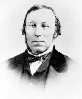
Alfred Penderell Waddington ( 1801-1872), British Columbia pioneer, in Yellowhead Pass. Waddington was born in London, educated in Paris and Germany, worked in France and Brazil, and was a partner in a grocery firm in California by 1858, when he went to Victoria to establish a branch of his firm. He sat in the British Columbia House of Assembly in 1861-2 and helped to draft the city charter in 1862. His book The Fraser mines vindicated; or, the history of four months (Victoria, 1858) may have been the first book printed in British Columbia. Waddington wrote it in the hope of checking the exodus of miners who had not succeeded in the first rush to the gold fields.
In 1864, Waddington attempted to build a road from Bute Inlet to the interior, an enterprise in which a party of his workmen were killed by the Chilcotin people, and through which he was ruined financially. He spent the rest of his life advocating a transcontinental railway and attempting to get a charter to build it. Sandford Fleming [1827–1915], chief engineer of the Canadian Pacific Railway, praised his planned route.
Named for Raphael Leonard von Zuben, a Canadian National Railways purchasing agent, who assisted the railroad with exploring the Canadian Rockies.
A vista is a view, especially one seen through a long and narrow opening. The feature was a camera station on the Alberta-British Columbia Boundary Commission survey, which worked through Yellowhead Pass in 1917.
Named in association with Vista Peak.
Bjørger Pettersen [1942– 2018] operated the Ranch of the Vikings near McBride from about 1970 until 1985. Starting in 1972, it was the training site for the Canadian national cross-country ski team.
Anita Petterson, who was born in Inuvik, won a gold medal at Canada Winter Games in 1975.

The north face of Mount Robson rises abruptly in a series of precipitos cliffs, rank on rank, to the very skies. At its base the Grand Forks River, swiftly flowing from Berg Lake, leaps a cliff as high as a Niagara and, plunging in a sccession of superb falls through a gorge over 3,000 feet deep, sweeps through the “Valley of a Thousand Falls” on its way to the Fraser. Photo by Rev. George Kinney, ca. 1907. National Geographic 1911
Dr. A. P. Coleman, Geologist of the University of Toronto, organized an expedition in 1907 to capture Mt. Robson. The party consisted of the Doctor and his brother, L.Q. Coleman, myself, and a helper. The four of us, with our pack-train of ten horses and outfit, left Laggan, August 2nd, 1907. We followed the Pipestone, Siffleur, Saskatchewan and Athabasca Rivers; crossing the Pipestone and Wilcox Passes. For weeks we made our own trails through the wilds, and forced our way through hundreds of miles of tangled underwood. We rested our weary limbs by many a beautiful lake and babbling brooklet, while our camp-fires lit the dark shadows of ravine and cliff. Rafting our stuff over the mighty Athabasca, across which we had to swim our horses, we hurried over the Yellowhead Pass, and swung down the Fraser. But our trip that year left Mt. Robson still unconquered, though we explored its western side, and I discovered Mt. Turner [Whitehorn Mountain] and “The Valley of a Thousand Falls.”
— George R. B. Kinney [1872–1961]
A little more than a mile below Berg Lake the northwest spur of Mt. Robson closely approaches the peaks across the Grand Fork Valley. Below this point is wider circle which heads in a fine glacier and icefall, previously referred to as lying beneath the east face of Mt. Whitehorn. The icefall is of a peculiar pointed shape and drops perpendicularly into a deep rock gorge opening to the lower shingle-flat, already mentioned as that through which the torrent from the glacier flows to join the Grand Fork. This circle has been named by Kinney “The Valley of a Thousand Falls.” It cannot be called a beautiful valley–tremendous cliffs and rock gorges are on every side and the feeling is one of austerity and gloom but it is very impressive and very wonderful. On a bright a sunny day the hanging and cliff glaciers on the surrounding heights of Robson and Whitehorn send down streams of water, which pour over cliffs in long, thread-like falls, some of them hundreds of feet in height. These, together with the falls already described and several others that come from the snowy peaks south of Mt. Whitehorn, give the appearance of numbers, and justify the name in some extent. Beyond the rock gorge of the glacier the eastern walls of Whitehorn rise tier on tier in awe inspiring precipices, and from between two titanic buttresses a tumbling glacier, showing a fine bunch of séracs, continually avalanches fragments to the valley below.
— Arthur Oliver Wheeler [1860–1945]
A valley in the mountains — that is how Canadian National Railroad officials saw the village when the former Canadian Northern Railway station house was moved from Swift Creek, a mile west, in 1927. Alexander Kushnir, the section foreman, was asked by the railroad to poll the local citizens concerning a name for the new location. The railroad suggested “Valemount” as an alternative to the suggestion of “Burgoyne,” commemorating Jim Burgoyne who had worked in the area for many years.
The Swift Creek post office was changed to Valemount in 1928.