Monthly Archives: March 2014

Mount Hammel

British Columbia. Mount
Between Ptarmigan Creek and Goat River
53.4836 N 120.9339 W — Map 093H07 — GoogleGeoHack
Name officially adopted in 1969
Official in BCCanada
Sergeant James Shannon Hammell

Sergeant James Shannon Hammell
Canadian Virtual War Memorial

Named to remember Canadian Army Sergeant James Shannon Hammel, M15887, from Snowshoe. Serving with the Loyal Edmonton Regiment, he was killed in action in Sicily on 5 August 1943, age 41.

Sgt. Hammel is buried at Agira Canadian War Cemetery, Sicily, grave B, H, 248. At the time of his death, he was survived by wife Horah Mary Shannon-Hammel of Prince Albert, Saskatchewan, and by parents Isaiah and Isabella Hammel.

References:

Mount Halvorson

British Columbia. Mount
SW of Legrand, E of Milk River
53.2589 N 120.5806 W — Map 093H07 — GoogleGeoHack
Name officially adopted in 1965
Official in BCCanada
Trooper Frank Halvorson

Trooper Frank Halvorson
Canadian Virtual War Memorial

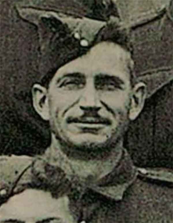
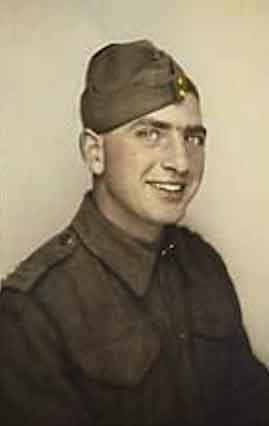
Named to remember Trooper Frank Halvorson, H45935, from McBride; serving with the 27th Armoured Regiment, Sherbrook Fusiliers, RCAC, when he was killed in action 29 October 1944.

Frank Halvorson was son of John and Ann Halvorson, of McBride. He was born in Edmonton on November 24, 1918,and enlisted July 3, 1940, at Port Arthur, Ontario.

The Sherbrooke Fusiliers Regiment was formed as an infantry unit in 1940. In 1942 it was converted to an armoured regiment and renamed 27th Armoured Regiment (Sherbrooke Fusilier Regiment) and joined 4th Armoured Brigade. They later transferred to the 2nd Canadian Armoured Brigade and saw action in Normandy and across Western Europe.

Halvorson is buried at Bergen-op-Zoom Canadian War Cemetery, Netherlands, grave 8, D, 7. Most of the soldiers buried at Bergen-op-Zoom Canadian War Cemetery lost their lives in the fighting north of Antwerp during the Battle of the Scheldt, as the 2nd Canadian Infantry Division, with support from the 4th Canadian Armoured Division, worked to clear the right (north) bank of the Scheldt estuary of German forces. Bergen-op-Zoom Canadian War Cemetery contains 1,118 Commonwealth burials of the Second World War, 31 of which are unidentified.

References:

Mount Goslin

British Columbia. Mount
NW of Mount Chamberlin
53.05 N 119.4333 W — Map 83E/3 — GoogleGeoHack
Name officially adopted in 1965
Official in BCCanada

Named to remember Canadian Army Private Earl William Goslin, M104002, from Tête Jaune Cache; serving with the Westminster Regiment, Royal Canadian Infantry Corps, when he was killed in action 16 December 1944; buried in the Villanova Canadian War Cemetery, Italy, grave V- A- 10.

Goslin was originally from the Cooking Lake area of Alberta. As of January 2001 he was survived by three sisters and a growing number of nieces and nephews and their progeny. He also may have had a daughter.

References:

  • Personal correspondence. Ron Thornton. Ron Thornton (grand-nephew), Edmonton, 2001
  • The Canadian Virtual War Memorial. CVWM, Private Earl William Goslin. CVWM
Also see:

Mount George Graham

British Columbia. Mount
N of junction Moose RiverandFraser River
52.96 N 118.7736 W — Map 083D15 — GoogleGeoHack
Name officially adopted in 1934
Official in BCCanada
Graham in 1922

Graham in 1922
Wikipedia

Politician George Perry Graham [1859–1943] was born in Eganville, Ontario. He became a member of the Ontario Legislature in 1898, and served there until 1907, when he was elected to the House of Commons. He was appointed Minister of Railways and Canals, and became Minister of Militia Defence and Minister of Naval Service in 1922. In 1925 he was appointed to His Majesty’s Privy Council and in 1926 to the Canadian senate.

This feature was personally selected in 1934 by the Honorable T. D. Pattulo, Premier of British Columbia, “… to be named Mount George Graham after Colonel the Right Honorable George Perry Graham, PC, LLD.”

References:

Mount Geikie

British Columbia. Mount
SE of Yellowhead Lake
52.7139 N 118.3914 W — Map 083D09 — GoogleGeoHackBivouac
Earliest known reference to this name is 1900 (McEvoy)
Name officially adopted in 1951
Official in BCCanada
Elevation: 3298 m

Tonquin Pass and Geikie Range from the North (Vista Peak).
Photo, A.0. Wheeler

Tonquin Pass and Geikie Range from the North (Vista Peak).
Photo, A.0. Wheeler
Canadian Alpine Journal1922

“The kingpin of the famous Tonquin Valley” was named in 1898 by geologist James McEvoy [1862–1935] after Sir Archibald Geikie [1835–1924], the Scottish geologist who was director-general of the Geological Survey of Great Britain from 1882 to 1901.

The name was officially adopted in 1924 as labelled on the 1912 topographic map Mount Robson 1912 by Arthur Oliver Wheeler [1860–1945].

Alpinist Arnold Louis Mumm [1859–1927] said that the north face of Mount Geikie was composed of the most tremendous precipices he had ever seen.

In 1913 certain striking peaks immediately south of Yellowhead Pass were located and measured by Wheeler from a station on Yellowhead Mountain. Mt. Geikie (11,016 ft.) on the continental divide was reported upon by him as a “magnificent first climb in store for some enterprising mountaineer and one that would challenge the highest skill and perseverance,” and so its fame went forth. Unfortunately that name has been locally applied to another peak visible from the railway at Jasper station. It was this latter “Geikie” [identified in a note as “Mt. Fitzhugh,” renamed Mount Edith Cavell in 1916] which became the goal of Mr. Mumm in 1914, when making his fifth visit to these parts with his faithful Inderbinnen.

— Fay 1915
References:

  • Wheeler, Arthur Oliver [1860–1945]. “Topographical Map Showing Mount Robson and Mountains of the Continental Divide North of Yellowhead Pass to accompany the Report of the Alpine Club of Canada’s Expedition 1911. From Photographic Surveys by Arthur O. Wheeler; A.C.C. Director.” Canadian Alpine Journal, Vol. 4 (1912):8-81
  • McEvoy, James [1862–1935]. “Map Showing Yellowhead Pass Route From Edmonton To Tête-Jaune Cache.” (1900). Natural Resources Canada
  • White, James [1863–1928]. “Place names in the vicinity of Yellowhead Pass.” Canadian Alpine Journal, Vol. 6 (1914–1915):107-114
  • Fay, Charles Ernest [1846–1923]. “Recent Mountaineering in the Canadian Alps.” Geographical Review, Vol. 2, No. 1 (1916):1. JSTOR
  • Wates, Cyril G. [1883–1946]. “Mount Geikie.” Canadian Alpine Journal, Vol. 13 (1923):47-53
  • Bulyea, H. E. “A trip to the Geikie valley.” Canadian Alpine Journal, Vol. 13 (1923):140
  • Wates, Cyril G. [1883–1946]. “The Geikie Valley in 1923.” Canadian Alpine Journal, Vol. 14 (1924):51-59
  • British Columbia Geographical Names. Mount Geikie
  • Wikipedia. Archibald Geikie

Mount Fraser

Alberta-BC boundary. Mount
Headwaters of Simon Creek and Astoria River
52.6564 N 118.3192 W — Map 083D09 — GoogleGeoHackBivouac
Name officially adopted in 1917
Official in BCCanada
Elevation: 3313 m
Tonquin Pass and Geikie Range from the North (Vista Peak).
Photo, A.0. Wheeler

Comprising Bennington Peak, McDonnell Peak, and Simon Peak, the mountain honors Simon Fraser [1776–1862].

Also see: