Monthly Archives: March 2014

Falls of the Pool

British Columbia. falls: Fraser River drainage
S of Emperor Falls on Robson River
53.1167 N 119.2 W — Map 83E/3 — GoogleGeoHack
Name officially adopted in 1956
Official in BCCanada

The 1911 Alpine Club of Canada–Smithsonian Robson Expedition was led by Arthur Oliver Wheeler [1860–1945]. On the Robson River below Emperor Falls, Wheeler in described “a second big fall of 150 feet. It suggests the name of the ‘Fall of the Pool.’ Two-thirds of the way down is a tiny pool in the rock into which the water leaps; the lower part is more broken.”

References:

  • Wheeler, Arthur Oliver [1860–1945]. “The Mountains of the Yellowhead Pass.” Alpine Journal, Vol. 26, No.198 (1912):382

Extinguisher Tower

British Columbia. Tower
SE of Berg Lake, E of Mount Waffl
53.1167 N 119.0875 W — Map 83E/3 — GoogleGeoHack
Earliest known reference to this name is 1908 (Coleman)
Name officially adopted in 1956
Official in BCTopo map from Canadian Geographical Names
Near the “Extinguisher,” Main Glacier. Arthur Coleman, 1908

Near the “Extinguisher,” Main Glacier. Arthur Coleman, 1908 The Canadian Rockies: New and Old Trails


From top, Conrad Kain, Albert H. MacCarthy, and Basil S. Darling on gendarme on east side of Extinguisher Tower. Mount Robson ACC Camp. Photo: Byron Harmon, 1913

From top, Conrad Kain, Albert H. MacCarthy, and Basil S. Darling on gendarme on east side of Extinguisher Tower. Mount Robson ACC Camp. Photo: Byron Harmon, 1913 Whyte Museum of the Canadian Rockies

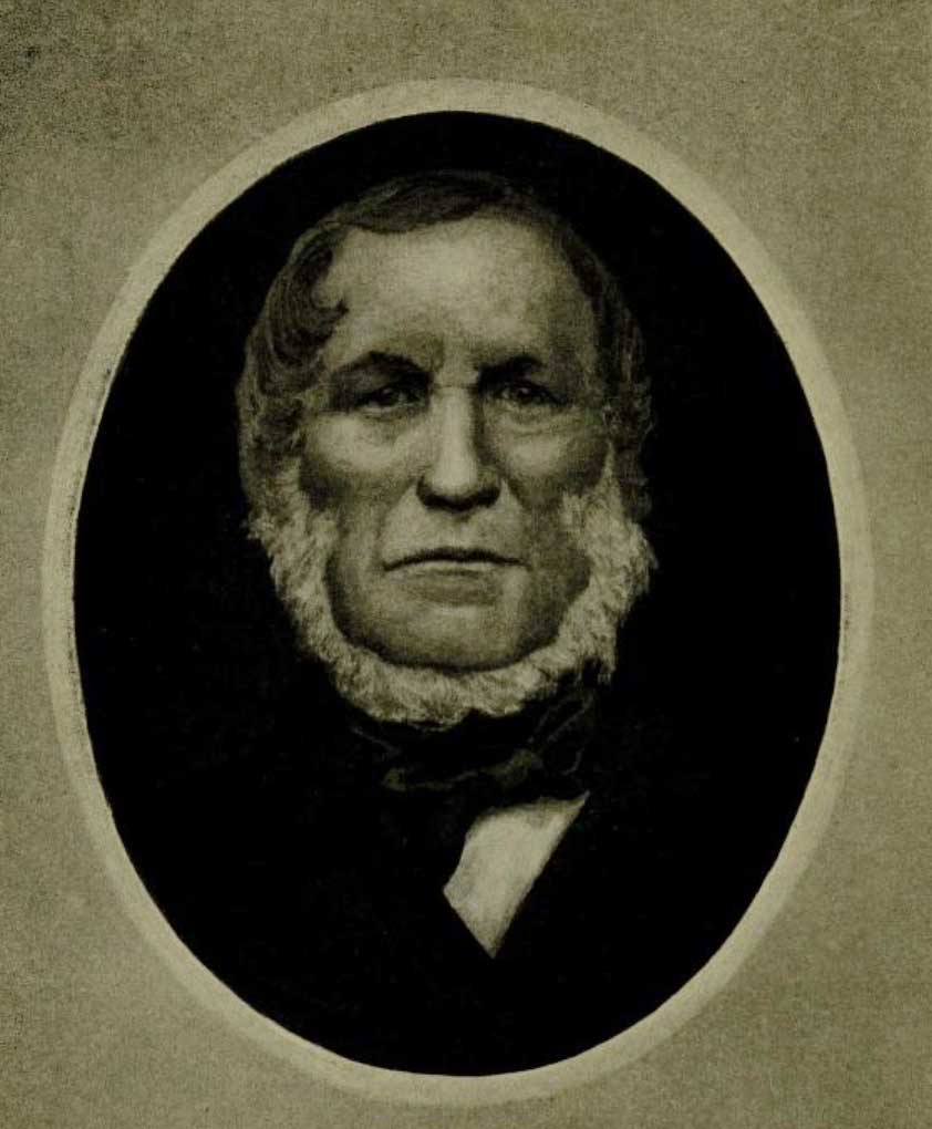
In 1917, while serving in the Canadan Army Medical Corps in France, George R. B. Kinney [1872–1961] wrote to Arthur Hinks, the secretary of the Royal Geographical Society in London, that he would be pleased to deliver a lecture on mountaineering in the Canadian Rockies, illustrated by “100 choice colored lantern slides, second to none (by report), and taken from my own negatives.… Mine are the original photographs taken of these hither to unexplored regions, and names like ‘Berg Lake,’ ‘Tumbling Glacier,’ ‘Robson Glacier,’ ‘Mt. Rearguard,’ ‘the Helmet,’ and ‘the Extinguisher’ that now have a permanency, were my suggestions, while Dr. Coleman gave the name of Lake Kinney on Mt. Robson’s western foot.” [1] Kinney delivered the lecture in January 1919, and was subsequently elected a Fellow of the RGS.

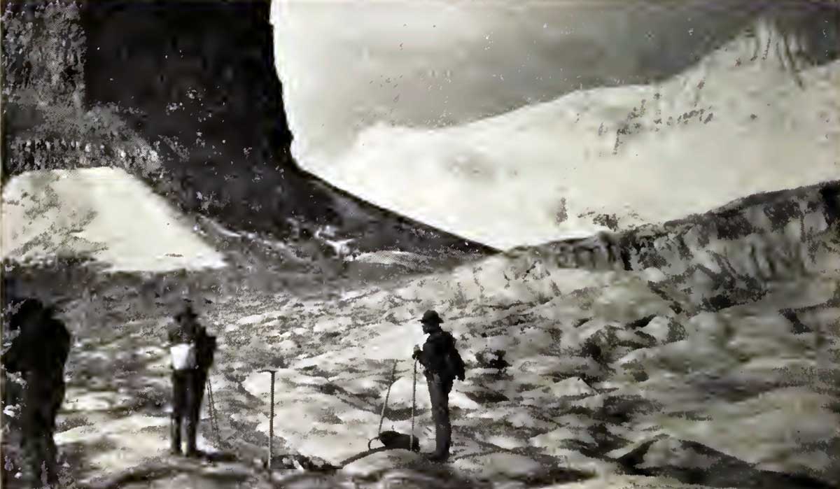
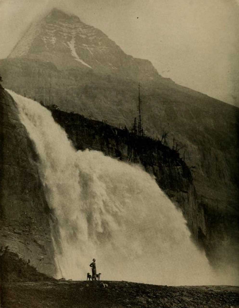
Kinney had accompanied Arthur Philemon Coleman [1852–1939] and Coleman’s brother Lucius on the first mountaineering expedition to Mount Robson in 1907, when they approached from the Fraser River side and got little further than Kinney Lake. They returned in 1908, guided by Adolphus Moberly [1887– ?] and John Yates [1880– ?], who took them up the Moose River valley and approached Robson from the north. They became the first people to report on Berg Lake, Tumbling Glacier, Robson Glacier, Rearguard Mountain, The Helmet, and Extinguisher Tower, features Kinney named after their appearances.

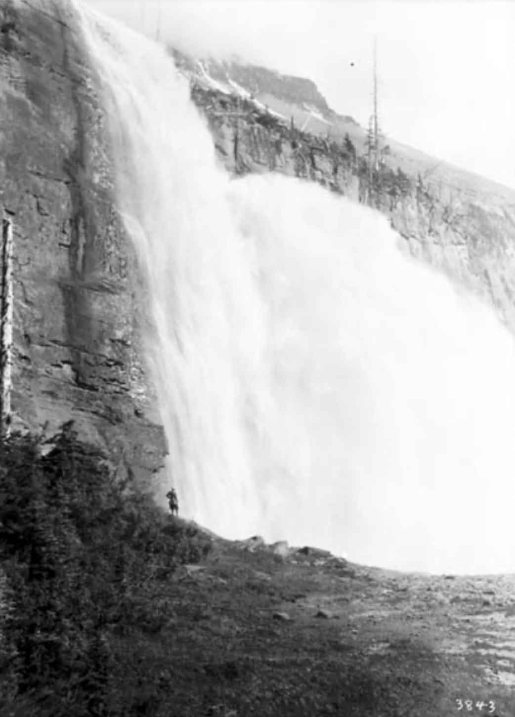
“At a bold tower of rock, which had been nicknamed the Extinguisher, the Robson glacier widens out and bends nearly at a right angle toward the main peak,” wrote Coleman. [2]

Smithsonian Institution director Charles Doolittle Walcott [1850–1927] called it the most valuable spot in the Rockies to geologists. “One of the names proposed by Dr. Coleman for a prominent monadnock that is surrounded by ice, east of Mount Robson, is ‘The Extinguisher’ and Mr. Wheeler has adopted the name on his map. I presume Dr. Coleman had in mind the conical extinguisher used in putting out candles in the olden times. It so happens that that particular mass of rock carries a very important bed of Cambro-Ordovician fossils, and will be referred to many times in the future in literature. It may be that I shall suggest a shorter and more euphonious name for it,” Walcott wrote to the Surveyor-General in 1912. [3]

His suggestion, “Billings Butte”, was not adopted. Walcott was referring to Arthur Oliver Wheeler [1860–1945].

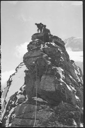
“On the cirque immediately below Mount Resplendent stands a quaint tower of rock some 500 feet above the ice, named the Extinguisher from its likeness to the conical cap once used to put out the candle,” wrote Elizabeth Parker [1856–1944], a member of the Alpine Club of Canada’s 1913 camp at Robson Pass. [4]

References:

  • 1. Kinney, George Rex Boyer [1872–1961]. London, England: Royal Geographical Society Archives. Letter to Arthur Hinks (1917).
  • 2. Coleman, Arthur Philemon P. [1852–1939]. The Canadian Rockies: New and Old Trails. London: T. Fisher Unwin, 1911. Internet Archive [accessed 3 March 2025]
  • 3. Walcott, Charles Doolittle D. [1850–1927]. “The monarch of the Canadian Rockies.” National Geographic Magazine, (1913):626. Internet Archive
  • 4. Parker, Elizabeth J. [1856–1944]. “A new field for mountaineering.” Scribner’s Magazine, 55 (1914)
Also see:

Everett Creek

British Columbia. Creek
Flows NE into Slim Creek, E of Tumuch Lake
53.7319 N 121.2828 W — Map 093H11 — GoogleGeoHack
Name officially adopted in 1958
Official in BCCanada

Everett Creek adopted in the 1930 BC Gazetteer, as labelled on a BC Lands’ map of 1923, not “East Fork Slim Creek” as identified on earlier maps.

References:

Ernest Peak

Alberta-BC boundary. Mount
On Mount Lyell, NE of Bush Arm, Kinbasket Lake
51.9572 N 117.1038 W — Map 082N14 — GoogleGeoHack
Name officially adopted in 1972
Official in BCCanada

One of the peaks of Mount Lyell, named for Swiss guide Ernest Feuz (1889-1972), a mountain guide for the Canadian Pacific Railway. He was the son of Edward Feuz Sr. and brother of Edward Feuz Jr.

Ernst Feuz came to Canada in 1909 and guided at Glacier House until 1925, when he was transferred to Lake Louise. The Feuz family lived at Golden, B.C.

The peaks on Mount Lyell include Rudolph Peak, Edward Peak, Ernest Peak, Walter Peak and Christian Peak (Canadian Permanent Committee on Geographical Names, 1972).

References:

  • Karamitsanis, Aphrodite [1961–]. Place names of Alberta. Volume 1: Mountains, Mountain Parks and Foothills. Calgary: University of Calgary Press, 1991
  • British Columbia Geographical Names. Ernest Peak
Also see:

Ermatinger Mountain

Alberta-BC boundary. Mount
Alta-BC boundary, SE of Athabasca Pass
52.4167 N 118.05 W — Map 83D/8 — GoogleGeoHackBivouac
Name officially adopted in 1921
Official in BCCanada
Elevation: 3073 m
This mount appears on:
Boundary Commission Sheet 26 (surveyed in 1920) [As “Mt. Ermatinger”]

The name commemorates fur trader Edward Ermatinger (1797–1876), who was born on the Mediterranean island of Elba where his father was employed by the British Army. Ermatinger was educated in England, and in 1818 apprenticed to Hudson’s Bay Company . In 1825 he was posted to the Columbia Department, which then included New Caledonia. He remained in the service of the HBC for ten years, and in 1830 retired to St. Thomas, Upper Canada.

References:

  • Ermatinger, Edward [1797–1876]. Edward Ermatinger’s York Factory express journal, being a record of journeys made between Fort Vancouver and Hudson Bay in the years 1827–1828. Ottawa: Transactions of the Royal Society of Canada, 1912. Internet Archive
  • Wallace, W. Stewart. MacMillan Dictionary of Canadian biography. Toronto: MacMillan, 1978
  • Wikipedia. Edward Ermatinger

Emperor Falls

British Columbia. Falls: Fraser River drainage
Robson River, SW of Berg Lake, NW of Mount Robson
53.1333 N 119.2 W — Map 83E/3 — GoogleGeoHack
Earliest known reference to this name is 1911 (Wheeler)
Name officially adopted in 1951
Official in BCCanada
The Emperor Falls. Photo: Byron Harmon, 1911

The Emperor Falls. Photo: Byron Harmon, 1911
Canadian Alpine Journal 1912


Emperor Falls, with Robson Peak above. Photo by R. C. W. Lett, courtesy of Grand Trunk Pacific Railway, 1913

Emperor Falls, with Robson Peak above. Photo by R. C. W. Lett, courtesy of Grand Trunk Pacific Railway, 1913
National Geographic Magazine 1913


Emperor Falls
William James Topley, 1914

Emperor Falls
William James Topley, 1914
Library and Archives Canada

The 1911 Alpine Club of Canada–Smithsonian Robson Expedition was led by Arthur Oliver Wheeler [1860–1945]. He wrote:

Below Berg Lake the Robson River enters a narrow rock canyon, and soon becomes a cascade, careening wildly down its bed and showing a great swirl of white water. Then comes a line of cliffs extending part way across the valley. Over this the river makes a grand and spectacular leap to a rock floor below, where it turns sharply to the left and pours madly though an extremely narrow box canyon which it has carved in the bed rock. The fall is magnificent and I know of no other of quite the same type. The total drop in 145 feet by aneroid barometer measurement. At a distance of 60 feet from the crest, the full volume of the water strikes a ledge and bounds outwards for 30 feet, creating a splendid rocket which gives the idea of a giant leap. There is such a feeling of majesty and power inspired by the spectacle that I christened it “The Emperor Falls.”

References:

  • Wheeler, Arthur Oliver [1860–1945]. “The Mountains of the Yellowhead Pass.” Alpine Journal, Vol. 26, No.198 (1912):382
  • Wheeler, Arthur Oliver [1860–1945]. “The Alpine Club of Canada’s expedition to Jasper Park, Yellowhead Pass and Mount Robson region, 1911.” Canadian Alpine Journal, Vol. 4 (1912):9-80
  • Walcott, Charles Doolittle [1850–1927]. “The monarch of the Canadian Rockies.” National Geographic Magazine, (1913):626. Internet Archive

Emperor (railway point)

British Columbia. Railway point
On CNR, S of Mount Robson
53.0167 N 119.2333 W — Map 83E/3 — GoogleGeoHack
Earliest known reference to this name is 1929 (CNR Timetables)
Name officially adopted in 1951
Not currently an official name
40 miles west of the Yellowhead Pass on the Canadian National Railway

Emperor (Station) adopted 1951 on Jasper Park (North), as identified in CNR Timetables from 1929 or earlier. Rescinded 1970.

Listed as a passenger stop in CNR Timetable #34, 29 October 1967 – mile 10.8 from Tete Jaune Cache; not listed in subsequent editions. No longer a stopping place according to 28 September 1970 advice from CNR/Victoria office.

References:

  • British Columbia Geographical Names. Emperor

Emerald Ridge

British Columbia. Ridge
S of Moose Lake
52.9183 N 118.9925 W — Map 083D15 — GoogleGeoHack
Name officially adopted in 1980
Official in BCCanada

“Emerald Ridge” adopted in 1973 as agreed by British Columbia, not “Avalanche Ridge” as identified on earlier maps. The name is applied to the ridgeline, not the entire massif.

[the ridge] …is distinctive for its great areas of slide slopes, many of which are mantled with bright green deciduous growth.

— memo from BC Parks 1972, file C.1.62
References:

Ella Frye Creek

British Columbia. Creek: North Thompson River drainage
Flows SE into North Thompson River, NW of junction with Albreda River
52.6167 N 119.6333 W — Map 83D/12 — GoogleGeoHack
Name officially adopted in 1963
Official in BCCanada
This creek appears on:
Zillmer maps of Cariboo 1939-1948 [1939]
Ella Frye, first registered female trapper, 1933

Ella Frye, first registered female trapper, 1933
Valemount & Area Museum

Ella Frye [1907–1995] trapped on the North Thompson river for over 50 years. Ella was born at Red Deer, Alberta, while her family was moving west from North Dakota. In 1911 her parents Fred and Edith (Bronson) arrived at Tête Jaune Cache, and soon afterwards moved to Albreda. Grandfather Bronson started teaching her trapping when she was six years old. “It got into my blood and I kept at it,” Ella said. She married Tom Smith around 1926. In 1933, she started trapping on the North Thompson.

In 1971, according to a report in the local newspaper, she was “the only woman in the area who is a licensed trapper.” Among her siblings were brothers Mike (“Small Frye”) [1911–1988] and Jules [1916–1980] and sister Francis [Knutson].

Francis’s husband Louis Knutson said that he started the trap line on this creek in 1910 and after spending a few years away from the area gave it to Ella.

References:

  • Zillmer, Raymond T. [1887–1960]. “The exploration of the Cariboo Range from the east.” American Alpine Journal, 5:2 (1944):261-274. American Alpine Club
  • Valemount Historic Society. Yellowhead Pass and its People. Valemount, B.C.: 1984
  • Robson Valley Courier. Weekly newspaper published by Pyramid Press of Jasper from 1968–88 (1968–1988).
  • Wheeler, Marilyn. The Robson Valley Story. McBride, B.C.: Sternwheeler Press, 2008
  • Columbia Basin Institute of Regional History. B.C.’s first registered female trapper. 2020 CBIRH. CBIRH
Also see: