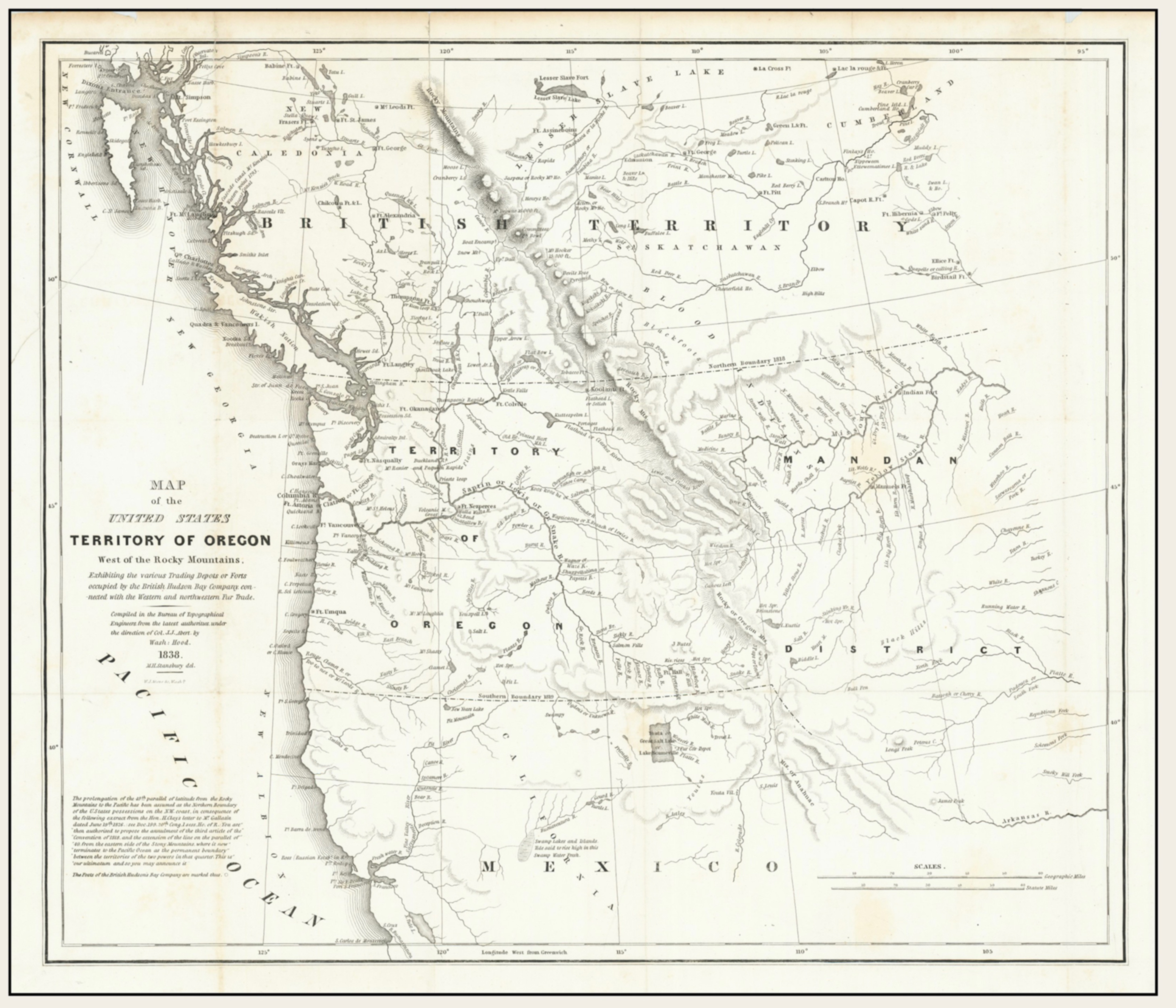
Category Archives: Map

David Thompson’s map of the North-West Territory of the Province of Canada 1814

Map of the North-West Territory of the Province of Canada.David Thompson, 1814

Map of the North-West Territory of the Province of Canada.David Thompson, 1814
Archives of Ontario

Map of the North-West Territory of the Province of Canada (1814)
Archives of Ontario, I0030317, David Thompson fonds
Reference Code: F 443, R-C(U), AO 1541

Surveying for the North West Company, David Thompson [1770–1857] located the headwaters of the Mississippi River, crossed the Rocky Mountains and mapped the entire length of the Columbia River.

Thompson retired from the fur trade in 1812 and moved his family to Terrebonne near Montreal. He was given a special assignment to plot all the Company’s posts on a comprehensive map of the Canadian West using the astronomical observations he had carefully recorded.

Thompson’s map is approximately 213 centimetres (84″) high by 328 centimetres (129″) long. It gave an accurate depiction of the vast territory traversed by the fur trade and location of Company posts.

References:

  • Nesbit, Jack [1949–]. Mapmaker’s Eye: The Mapmaker’s Eye: David Thompson on the Columbia Plateau. Pullman: Washington State University Press, 2006

James McEvoy’s 1900 map showing Yellowhead Pass route from Edmonton to Tête-Jaune Cache

Map Showing Yellowhead Pass Route From Edmonton To Tête-Jaune Cache. James McEvoy, 1900.

Map Showing Yellowhead Pass Route From Edmonton To Tête-Jaune Cache. James McEvoy, 1900.
Natural Resources Canada


Map Showing Yellowhead Pass Route From Edmonton To Tête-Jaune Cache. 
James McEvoy, 1900. (Detail of Yellowhead Pass to Tête Jaune Cache)

Map Showing Yellowhead Pass Route From Edmonton To Tête-Jaune Cache.
James McEvoy, 1900. (Detail of Yellowhead Pass to Tête Jaune Cache)
Natural Resources Canada

James McEvoy [1862–1935] — Map showing the Yellowhead Pass route from Edmonton to Tête-Jaune Cache, 1900.

In 1898 McEvoy surveyed the Athabasca River valley for about 240 kilometres east of the Yellowhead Pass, and down the Fraser River on the west side of the pass for another 120 kilometres.

The splendid report of James McEvoy, published by the Geological Survey of Canada in 1900, dealing with the geology and natural history resources of the country traversed by the Yellowhead Pass route from Edmonton to Tête-Jaune Cache, contains the most comprehensive and reliable geographical information that has yet been published, and also contains the only geographical map published of that route on a sufficiently large scale to be of value.

Arthur Oliver Wheeler [1860–1945], 1912
References:

  • McEvoy, James [1862–1935]. Report on the geology and natural resources of the country traversed by the Yellowhead Pass route from Edmonton to Tête Jaune Cache comprising portions of Alberta and British Columbia. Ottawa: Geological Survey of Canada, 1900. Natural Resources Canada
  • McEvoy, James [1862–1935]. “Map Showing Yellowhead Pass Route From Edmonton To Tête-Jaune Cache.” (1900). Natural Resources Canada
  • Wheeler, Arthur Oliver [1860–1945]. “The Alpine Club of Canada’s expedition to Jasper Park, Yellowhead Pass and Mount Robson region, 1911.” Canadian Alpine Journal, Vol. 4 (1912):9-80

Coleman’s map Mount Robson 1911

Map of Mount Robson based on expeditions in 1907 and 1908. By A. P. Coleman.

Map of Mount Robson based on expeditions in 1907 and 1908. By A. P. Coleman.
Canadian Alpine Journal, 1910


Mt. Robson Region map by A. P. Coleman, 1911

Mt. Robson Region map by A. P. Coleman, 1911
The Canadian Rockies : new and old trails, p. 264

Canadian geologist Arthur Philomen Coleman [1852–1939] made extensive early explorations of the Canadian Rockies, including the first attempts to climb Mount Robson in 1907 and 1908.

References:

  • Coleman, Arthur Philemon [1852–1939]. “Expedition to Mt. Robson.” Canadian Alpine Journal, Vol. 1, No. 2 (1908):100-103
  • Coleman, Arthur Philemon [1852–1939]. “Geology and glacial features of Mt. Robson.” Canadian Alpine Journal, Vol. 2, No. 2 (1910):73-78
  • Coleman, Arthur Philemon [1852–1939]. “Mount Robson, the Highest Point in the Canadian Rockies.” The Geographical Journal (London), Vol. 36, No. 1 (July 1910). JSTOR
  • Coleman, Arthur Philemon [1852–1939]. The Canadian Rockies: New and Old Trails. London: T. Fisher Unwin, 1911. Internet Archive
Also see: