Monthly Archives: March 2014

Longworth

British Columbia. Locality
On Canadian National Railway, NW of Penny
53.9167 N 121.4667 W — Map 093H14 — GoogleGeoHack
Earliest known reference to this name is 1911 (GTP map)
Name officially adopted in 1983
Official in BCCanada
168 miles west of the Yellowhead Pass on the Canadian National Railway
Mile 79 in Fraser Subdivision (McBride to Prince George as of 1977)
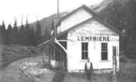
Grand Trunk Pacific Railway station built in 1914. Removed 1963

The name was submitted to the Geographical Board of Canada by Sir Alfred Smithers, chairman of the Grand Trunk Pacific Railway during construction of the rail link. The post office opened in October, 1915.

Longworth is located 80 miles west of McBride, it was quite possibly named after an English village in Oxfordshire, UK., (speculation on my part). It may have been one of the place names suggested by Josiah Wedgwood.

— Olson

Wrigley Directories for 1918 lists Longworth as a post office and station on the Grand Trunk Pacific Railway. Population 30. Local resources: Timber, prospecting, and a few small farms. There are no sawmills here and the district offers 25,000,000 feet which may be purchased cheaply from pre-emptors, while twice the amount is available on Government land adjacent to rail. Arthur E. Read was postmaster and ran the general store,and was also the first president of the Yellowhead Association around 1930.

The town of Longworth is on the map to stay. The place now boasts of a population of 100 residents, a good school, church, dance hall, store, post office and pool room. For awhile the settlement had a cabaret but it has been closed up and the piano taken away for repairs. In 1920 the post office was moved into the Toneko Lodge, a majestic wooden structure which also served as a hotel and general store.

Prince George Citizen, February 28, 1924. Quoted by Olson
References:

  • Wrigley Directories, Limited. Wrigley’s British Columbia Directory. Vancouver: 1918. Internet Archive
  • Olson, Raymond W. Ghost Towns on the East Line. Prince George, B.C.: Raymond W. Olson, 2017
  • British Columbia Geographical Names. Longworth

Little Shuswap Creek

British Columbia. creek: Fraser River drainage
Former name for Kiwa Creek
53.0217 N 119.5636 W GoogleGeoHack
Not currently an official name.

In his “Notes on the Cariboo Range” of 1925, Munday wrote, “The local name of the Big Shuswap conflicts with the Shuswap River further south and appears on recent government maps as Raushwap or Rausch River (from Riviere au Shuswap). Kiwa Creek is known locally as Little Shuswap.”

References:

  • Munday, Walter Alfred Don [1890–1950]. “In the Cariboo Range – Mt. David Thompson.” Canadian Alpine Journal, Vol. 15 (1925):130-136
Also see:

Little Grizzly

British Columbia. Former name
Former name of Cinnamon Peak
53.0797 N 119.2572 W GoogleGeoHack
Not currently an official name.

In 1911, Arthur Oliver Wheeler [1860–1945] named this mountain Little Grizzly Peak “on account of its resemblance, on a small scale, to Mount Grizzly in the Selkirks.” Cinnamon is a coloration of the grizzly bear.

References:

  • Wheeler, Arthur Oliver [1860–1945]. “The mountains of the Yellowhead Pass.” Alpine Journal, Vol. 26, No.198 (1912):382

Lindup

British Columbia. Railway Point
Canadian National Railway, SE of Longworth, NW of Guilford
53.8833 N 121.3667 W — Map 93H/14 — GoogleGeoHack
Earliest known reference to this name is 1911 (GTP map)
Name officially adopted in 1984
Not currently an official name
163 miles west of the Yellowhead Pass on the Canadian National Railway
Mile 75 in Fraser Subdivision (McBride to Prince George as of 1977)
Grand Trunk Pacific Railway station built in 1914. The Lindup station was moved to Penny in 1947.

LINDUP: a settlement on the G. T. P. Ry., 5 miles west of Penny, no agent, in Prince George Provincial Electoral District. Has Canadian Express. Charges must be prepaid; tele- graph office.

Population 5. Local resources: Saw mills and mixed farming. Heavily timbered unbroken land about 3 miles distant from the mountains.

Address mail Lindup via Penny or Longworth.

Bochscski M section hand
Hall Harold farming
Jardine Carl section foreman
Jardine Chas farming
Lehman F farming
Persons G homesteader
Segel G lineman G T P

— Wrigley 1918

Torsten Berg was the only one to operate a sawmill at Lindup. The mill operated from 1949 to 1952, at which time his timber supply ran out and he moved the mill to Longworth. The timber at Lindup was of nice quality and of good size. Torsten was awarded the contract to supply planks 26 feet long, for the podium for Queen Elizabeth’s coronation in 1952.

The population of Lindup peaked at about 50 people in 1929 and dwindled dramatically the Depression. In 1931 the Prince George Citizen reported that a large relief camp of 100 men were clearing and grubbing road right of way.

Lindup in 2014 does not have any residents and is on a seasonal road that is susceptible to weather restrictions.

— Olson
References:

  • Wrigley Directories, Limited. Wrigley’s British Columbia Directory. Vancouver: 1918. Internet Archive
  • Olson, Raymond W. Ghost Towns on the East Line. Prince George, B.C.: Raymond W. Olson, 2017

Lempriere

British Columbia. Railway Point
Canadian National Railway, S of junction of Albreda River and North Thompson River
52.45 N 119.1333 W — Map 83D/6 — GoogleGeoHack
Earliest known reference to this name is 1917
Name officially adopted in 1962
Official in BCCanada
88 miles west of the Yellowhead Pass on the Canadian National Railway
Mile 106 in Albreda Subdivision (Jasper to Blue River as of 1977)
Canadian Northern Railway station built in 1915
This railway point appears on:
Canadian National Railway map 1925
Lempriere Station, from the late 1970s/early 1980s. Photo by Brian Lempriere

Lempriere Station, from the late 1970s/early 1980s. Photo by Brian Lempriere
Real Royal Engineers

Arthur Reid Lempriere [1835–1927], a lieutenant in the Royal Engineers, arrived in Esquimalt in 1859 with the main body of the Columbia Detachment, the third and largest group of Royal Engineers to come to British Columbia. In 1859 he explored the route from Hope to Lytton via the Coquihalla. Lempriere returned to England in 1863, and retired as Major General in 1882.

The Canadian Northern Railway laid tracks through the Valemount area in 1915 and Lempriere first appears on a map of 1917. The Lempriere post office was open from 1942 to 1945. Less than ten cancellation marks are known in collections. There was a Japanese internment camp here during World War II.

References:

  • Woodward, Francis M. “Influence of the Royal Engineers in the development of British Columbia.” BC Studies, (1974)
  • Topping, William. A checklist of British Columbia post offices. Vancouver: published by the author, 7430 Angus Drive, 1983
  • Akrigg, Helen B., and Akrigg, George Philip Vernon [1913–2001]. British Columbia Place Names. Vancouver: UBC Press, 1997. Internet Archive
  • Lieutenant Arthur Reid Lempriere. 2006 The Real Royal Engineers. The Real Royal Engineers
  • Wikipedia. Arthur Reid Lempriere
Also see:

Legrand

British Columbia. Railway Point
Canadian National Railway, between Rider and Lamming Mills
53.4167 N 120.3833 W — Map 93H/8 — GoogleGeoHack
Earliest known reference to this name is 1911 (GTP map)
Name officially adopted in 1983
Official in BCCanada
103 miles west of the Yellowhead Pass on the Canadian National Railway
Mile 13 in Fraser Subdivision (McBride to Prince George as of 1977)
Grand Trunk Pacific Railway station built in 1914

The community was named after Joseph G. Legrand [1861-1923], a French-born engineer who designed and supervised the construction of all of the bridges on the Grand Trunk Pacific Railway. Legrand emigrated to Canada in 1891. Between 1893 and 1903 he worked successively as a draftsman, checker, and designer of bridge work and in 1903 was appointed assistant chief engineer of the predecessor firm that became the Montreal Locomotive Works. He joined the Grand Trunk Pacific Railway in 1906, at age 45, and assumed responsibilty for designing and overseeing the building of all the bridges on the new railway, thus becoming one of its senior managers.

Fourteen miles west of McBride, Legrand became a farming community. In 1921 six farmers lived there. The Legrand post office was open from August 1924 to June 1925, under postmaster Mrs. Janetta Somerville.

References:

  • CN (Canadian National Railway). Transportation planning branch, Edmonton, and historical office, Montréal. 2000
  • Davies, David L. “Not ‘A Bridge Too Far’ But One Far Enough or How the G.T.P. Crossed the Fraser at Prince George, British Columbia.” Canadian Rail, No. 476 May-June (2000):67–82. Exporail
  • Olson, Raymond W. Ghost Towns on the East Line. Prince George, B.C.: Raymond W. Olson, 2017