Author Archives: Swany

Craig Brook

British Columbia. Brook: Fraser River drainage
Flows SW into Fraser E of Horsey Creek
53.0717 N 119.655 W — Map 083E04 — GoogleGeoHack
Name officially adopted in 1999
Official in BCCanada

On August 22, 1911, Ernest C. Cox at Cranberry Lake (Valemount) wrote in his diary, “Saw Craig, the Fire Warden, Ed Garrett, and Kennedy.”

Stan Craig farmed at Croydon, east of Horsey Creek, and worked on the railroad atSwiftwater and other stations. He was listed in the 1943 Mount Robson post office directory as “section-man on the CNR,” a job he had held since 1918.

References:

  • Valemount Historic Society. Yellowhead Pass and its People. Valemount, B.C.: 1984

Craibenn Creek

British Columbia. Former railway point
On Canadian National Railway at Lamming Mills
53.3506 N 120.2469 W — Map 093H08 — GoogleGeoHack
Name officially adopted in 1989
Not currently an official name.
97 miles west of the Yellowhead Pass on the Canadian National Railway
This former railway point appears on:
Grand Trunk Pacific Railway stations

In the 1920s, to accommodate J. Bennett’s pole-cutting operation, Cariboo was moved to Mile 7 west of McBride. The station was renamed after Bennett and D. A. Craig, the section foreman. In 1928, Craibenn had four settlers and a government ferry.

References:

  • Olson, Raymond W. Ghost Towns on the East Line. Prince George, B.C.: Raymond W. Olson, 2017
Also see:

Cow Dung Lake

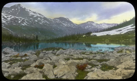
British Columbia. Lake: Fraser River drainage
Former name of Yellowhead Lake
Earliest known reference to this name is 1824 (Simpson)
Not currently an official name.
4 miles west of the Yellowhead Pass on the Canadian National Railway

In 1824, George Simpson [1792–1860], heading for the Athabasca Pass, noted, “the track for Cranberry Lake takes a Northerly direction by Cow Dung River.” The Cow Dung River was the Miette and Simpson’s Cranberry Lake may have been preset-day Yellowhead Lake.

John Arrowsmith’s 1859 map shows “Cow dung L.” as the western lobe of Yellowhead Lake (the eastern lobe is labeled “Moose L.”).

In 1862, when the Overlander gold seekers crossed Yellowhead Pass (which they called Leather Pass) they camped on Cow Dung Lake. A year later, the lake was known to Milton and Cheadle as Buffalo Dung Lake.

The name “Cowdung L.” appears on B.C. Surveyor General Joseph Trutch’s 1871 map of British Columbia, between Moose Lake and the Yellowhead or Leather Pass.

References:

  • Simpson, George [1792–1860], and Merk, Frederick [1887–1977], editor. Fur trade and empire. George Simpson’s journal entitled Remarks connected with fur trade in consequence of a voyage from York Factory to Fort George and back to York Factory 1824-25. Cambridge, Mass.: Harvard University Press, 1931. University of British Columbia Library
  • Arrowsmith, John [1790–1873]. Provinces of British Columbia and Vancouver Island; with portions of the United States and Hudson’s Bay Territories. 1859. UVic
  • Milton, William Wentworth Fitzwilliam [1839–1877], and Cheadle, Walter Butler [1835–1910]. The North-West Passage by Land. Being the narrative of an expedition from the Atlantic to the Pacific, undertaken with the view of exploring a route across the continent to British Columbia through British territory, by one of the northern passes in the Rocky Mountains. London: Cassell, Petter and Galpin, 1865. Internet Archive

Cottonwood River

British Columbia. Local name: Fraser River drainage
Local name of Castle Creek
53.2333 N 120.0333 W GoogleGeoHack
Earliest known reference to this name is 1909 (Washburn)
Not currently an official name.
This local name appears on:
Collie’s map Yellowhead Pass 1912

“Cottonwood River,” the local name of Castle Creek, was known to travel writer Stanley Washburn [1878–1950] in 1909, among those names “given by the trappers.”

References:

  • Washburn, Stanley [1878–1950]. Trails, Trappers and Tenderfeet in the New Empire of Western Canada. New York and London: Henry Holt, Andrew Melrose, 1912. Hathi Trust

Committee Punch Bowl

Alberta-BC boundary. Lake
Athabasca River and Columbia River drainages
Headwaters of Pacific Creek and Whirlpool River
52.3917 N 118.175 W — Map 83D/8 — GoogleGeoHack
Earliest known reference to this name is 1824 (Simpson)
Name officially adopted in 1930
Official in BCTopo map from Canadian Geographical Names
Committee’s Punch-bowl at the Source of the Whirlpool River. Hand-coloured lantern slide by Mary T.S. Schäffer. Photo taken in 1908

Committee’s Punch-bowl at the Source of the Whirlpool River. Hand-coloured lantern slide by Mary T.S. Schäffer. Photo taken in 1908
Archives Canada

Hudson’s Bay Company governor George Simpson [1792–1860] described crossing the Athabasca Pass in 1824:

At the very top of the pass or height of Land is a small circular Lake or Basin of water which empties itself in opposite directions and may be said to be the source of the Columbia and Athabasca Rivers as it bestows its favors on both these prodigious Streams. That this basin should send its Waters to each side of the Continent and give birth to two of the principal rivers in North America is no less strange than true both the Dr. & myself having examined the currents flowing from it East and West and the circumstance appearing remarkable I thought it should be honored by a distinguishing title and it was forthwith named the “Committee’s Punch Bowl.”

The Doctor was John McLoughlin [1784–1857]. The Committee was the executive of the Hudson’s Bay Company.

Fur trader Alexander Ross [1783–1856], who was travelling with Simpson’s party, published this account in 1825:

On the top of this height was six inches of newly-fallen snow, and a small circular pond of water about twenty feet in diameter. This height I named after our Governor, Mount Simpson ; and the basin of water on its top, the Governor’s Punch Bowl. No elevated height in this country can present a more interesting prospect than that viewed from the top of Mount Simpson: to the west, in particular, it is of a highly picturesque character.

Fur traders paused at this natural campsite to drink a toast “to their Honours the Governors,” the governing committee of the Hudson’s Bay Company in London.

The Athabasca Pass forms the watershed between the two great river systems of the Athabasca and the Columbia, whose waters flow out at either end (a somewhat rare and remarkable phenomenon) of a small mountain tarn rejoicing in the name of “The Committee’s Punch-Bowl.” West and east of the tarn, forming the Titanic pillars of this natural gateway to the north, were said to be the two great peaks, Mount Brown and Mount Hooker.

— Stutfield 1903

A lake with this “rare and remarkable phenomenon” is called a bifurcation lake.

References:

  • Simpson, George [1792–1860], and Merk, Frederick [1887–1977], editor. Fur trade and empire. George Simpson’s journal entitled Remarks connected with fur trade in consequence of a voyage from York Factory to Fort George and back to York Factory 1824-25. Cambridge, Mass.: Harvard University Press, 1931. University of British Columbia Library
  • Ross, Alexander [1783–1856]. Fur Hunters of the Far West. A Narrative of Adventures in the Oregon and Rocky Mountains. Vol II. London: Smith, Elder and Co., 1855. Internet Archive
  • Stutfield, Hugh Edward Millington [1858–1929], and Collie, John Norman [1859–1942]. Climbs and Explorations in the Canadian Rockies. London: Longmans, Green, 1903. University of British Columbia Library
  • Schäffer Warren, Mary T. S. [1861–1939]. Old Indian trails. Incidents of camp and trail life, covering two years’ exploration through the Rocky Mountains of Canada. [1907 and 1908]. New York: Putnam, 1911. Internet Archive

Colonel Pass

Alberta-BC boundary. Pass
Between Colonel Creek and Snaring River
53.0833 N 118.7667 W — Map 83E/2 — GoogleGeoHack
Earliest known reference to this name is 1922
Name officially adopted in 1923
Official in BCCanada

Named in association with “The Colonel” (mountain).

Also see:

Colonel Creek

British Columbia. Creek: Fraser River drainage
Flows W into Moose River NW of Salient Mountain
53.0736 N 118.8622 W — Map 083E02 — GoogleGeoHack
Name officially adopted in 1923
Official in BCCanada

Named in association with “The Colonel” (mountain). Adopted in 1923 as labelled on Wheeler’s map of Mount Robson (1912).

Also see: