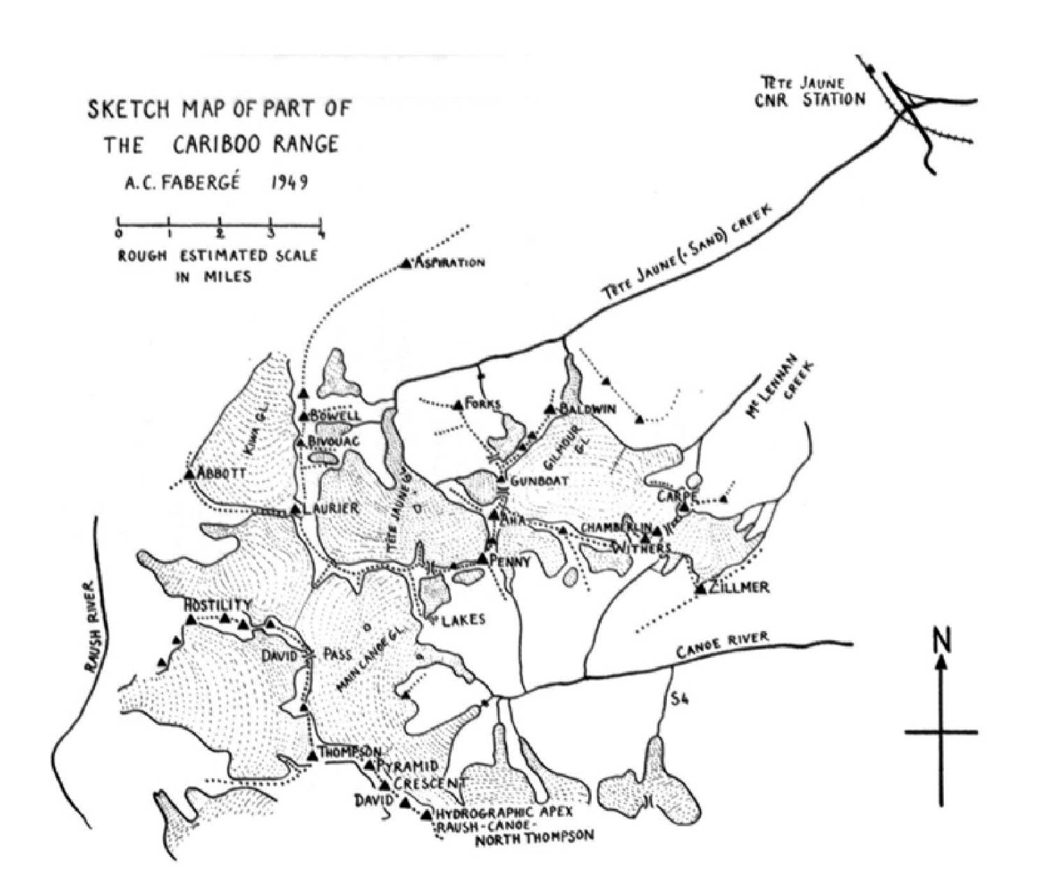
Former name of Hugh Allan Creek
Not currently an official name.
- Phillips, Donald “Curly” [1884–1938]. “Athabaska Pass to Tonquin Valley via Goat and Fraser Rivers.” Canadian Alpine Journal, Vol. 13 (1923):153

A group of white tents in a clearing, photographed from above. Andrew J. Gilmour Collection AJG.B4A8.007
American Alpine Club

Detail of map of Smoky River Pass
Quesnelle, B. C. to Edmonton, N.W.T.
by C. F. Hanington, 1875
Internet Archive
Charles Francis Hanington [1848–1930] accompanied Edward Worrell Jarvis [1846–1894] on a Canadian Pacific Railway survey of potential passes north of the Yellowhead. A hard trip they had of it, with dogsleds from Quesnel through the McGregor and Smoky Rivers, finding no better passes than the Yellowhead.
![[Map to accompany Winter conditions north and west of Mt. Robson]
Donald Phillips, 1915](/wp-content/uploads/2022/01/phillips-map-robson-caj1915.jpg)
[Map to accompany Winter conditions north and west of Mt. Robson]
Donald Phillips, 1915
Canadian Alpine Journal 1915
Includes many unofficial names: Muddy River, Sulphur River, Ptarmigan Lake, Rockslide Creek, Sulphur Pass, No Luck Creek, Snow River, Mirror Canyon, Calumet Snowfield, Twin Tree Lake, Mt. Pamm, Rockslide Creek, Short River…

Region about Mt. Alexander
Samuel Prescott Fay, 1913
Canadian Alpine Journal 1915

Map of route from Jasper to Mt. Sir Alexander.
Samuel Prescott Fay
Canadian Alpine Journal 1929
“Pete” Fay as he was known to his friends had been a member of the [American Alpine] Club for 59 years at the time of his death last August [1971]. His qualifications for election in 1912 were four seasons in the Canadian Rockies beginning in 1906. In 1914 he joined a Smithsonian expedition which left Jasper, Alberta in June for the purposes of exploration, mapping and the collection of birds and mammals in the northern Rockies. Reports were filed with the Biological Survey in Washington. In mid-October the party met a trapper who showed them an old newspaper with reports of the first weeks of World War I of which they had no inkling. For the next three or four days they traveled non-stop to reach Hudson Hope on the Peace River.
Pete graduated from Harvard in 1907. During World War I he joined the American Field Service to drive an ambulance in France and later served with the Air Force in France and Belgium. Afterwards he was associated with an investment counseling firm in Boston for many years. Aside from two years on the Council (1930-1932), he did not take an active part in Club affairs, though he attended frequent meetings. Frail health confined him to his home for the last ten or more years.
— Hall, American Alpine Journal, (1972)

View of Blue or Tumbling Glacier from its névé on the slope of Robson Peak to where its foot enters Berg Lake, a descent of 5,000 feet. Photo: R. C. W. Lett
National Geographic Magazine 1913
“From the elevated ice-field, fed by avalanching snows from the sides of Robson, a gigantic ice cascade tumbles down rock precipices and buries its nose in the waters of Berg Lake,” wrote Arthur Oliver Wheeler after his 1911 visit. “At frequent intervals great chunks of ice break off with a report like cannon, and, bounding and rattling down the steep incline, plunge into the clear water of the lake. Dr. Coleman has named the overhanging ice-fall ‘The Blue Glacier,’ The term is not strong enough: ‘Tumbling Glacier,’ though not so euphonious, is a better name to express the activity of such a unique feature.”
Near the headwaters of Bad River, traversed by Alexander Mackenzie [1764–1820] in 1793 on his way to the Pacific coast and back.
Alhough it is shown on NTS map 093I05, the name “Little Lake” does not appear on the Canadian Geographical Names Database.

Map of Mackenzie’s track in 1793 (detail of pass through Rocky Mountains)
Internet Archive
Friday, 16 August, 1793. The weather continued to be the same as yesterday, and at two in the afternoon we came to the carrying-place which leads to the first small lake; but it was so filled with drift wood, that a considerable portion of time was employed in making our way through it. We now reached the high land which separates the source of the Tacoutche Tesse, or Columbia River, and Unjigah, or Peace River: the latter of which, after receiving many tributary streams, passes through the great Slave Lake, and disembogues itself in the Frozen Ocean, in latitude 69-1/2 North, longitude 135. West from Greenwich; while the former, confined by the immense mountains that run nearly parallel with the Pacific Ocean, and keep it in a Southern course, empties itself in 46. 20. North latitude and longitude 124. West from Greenwich.
Mackenzie believed it to be the Columbia, or a major tributary thereof, and Lewis, and Clark, in 1805 the next non-Indigenous party to cross the northern part of the continent of North America, shared the assumption. Mackenzie’s coordinates are accurate for the mount of the Mackenzie River, to which the Unjigah or Peace is a tributary. His coordinates for the mouth of the Columbia River are also accurate, but he was mistaken in thinking that Tacoutche Tess was the Columbia; it is the Fraser River, neither the Columbia nor a tributary, but this was not discovered until 1807 by Simon Fraser.
Named in recognition of Captain James Herrick McGregor [1869–1915], Provincial Land Surveyor, who fell at Ypres 25 April 1915.
The portage was that of the party of Alexander Mackenzie [1764–1820], which crossed the Continental Divide on June 12, 1793:
We landed and unloaded, where we found a beaten path leading over a low ridge of land [the Continental Divide] of eight hundred and seventeen paces in length to another small lake [Portage Lake]. The distance between the two mountains at this place is about a quarter of a mile, rocky precipices presenting themselves on both sides. A few large spruce trees and liards were scattered over the carrying-place. There were also willows along the side of the water, with plenty of grass and weeds. The natives had left their old canoes here, with baskets hanging on the trees, which contained various articles. From the latter I took a net, some hooks, a goat’s horn, and a kind of wooden trap, in which, as our guide in formed me, the ground hog is taken. left, however, in exchange, a knife, some fire-steels, beads, awls &c. Here two streams tumble down the rocks from the right, and lose themselves in the lake which we had left [Arctic Lake]; while two others fall from the opposite heights, and glide into the lake which we were approaching [Portage Lake]; this being the highest point of land dividing these waters, and we are now going with the stream. This lake runs in the same course as the last, but is rather narrower, and not more than half the length. We were obliged to clear away some floating drift-wood to get to the carrying place, over which is beaten path of only an hundred and seventy-five paces long. The lake empties itself by a small river, which, if the channel were not interrupted by large trees that had fallen across it, would have admitted of our canoe with all its lading: the impediment, indeed, might have been removed by two axe-men in a few hours.