Alberta-BC boundary. Mount
S of Morkill Pass at head of Forgetmenot Creek
53.65 N 119.7333 W — Map 083E12 — Google — GeoHack
Name officially adopted in 1925
Official in BC – Canada
S of Morkill Pass at head of Forgetmenot Creek
53.65 N 119.7333 W — Map 083E12 — Google — GeoHack
Name officially adopted in 1925
Official in BC – Canada
This mount appears on:
Boundary Commission Sheet 37 (surveyed in 1923 & 1924)
Pre-emptor’s map Tête Jaune 3H 1931
Boundary Commission Sheet 37 (surveyed in 1923 & 1924)
Pre-emptor’s map Tête Jaune 3H 1931
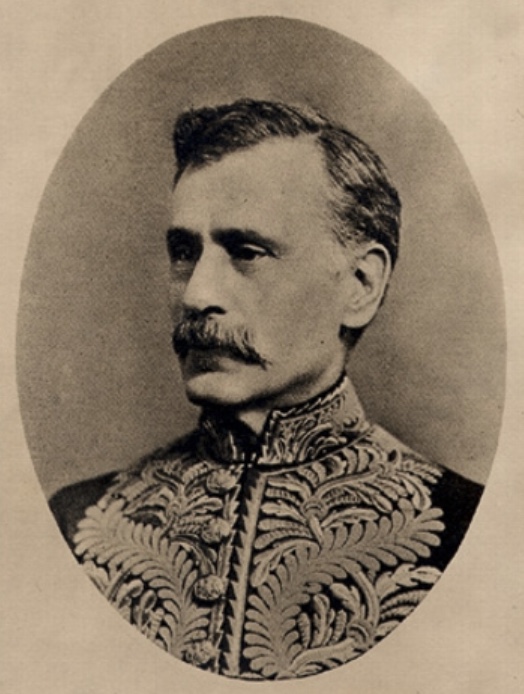
Portrait of Amédée Emmanuel Forget (1847-1923)
Wikipedia
Amedée E. Forget [1847–1923] of Banff, Alberta, was Lieutenant Governor of the Northwest Territories from 1898 to 1905, and senator from 1911 to 1923. “Senator Forget and Mrs. Forget are in the old Bell-Irving house on Beaver Avenue,” said a Banff newspaper report in 1911, “while the Senator is having his lot at the corner of Buffalo and Muskrat cleared to build a summer bungalow. The Senator intends making Banff his summer home and Ottawa his winter residence.”
References:
- Holmgren, Eric J., and Holmgren, Patricia M. Over 2,000 place names of Alberta. Saskatoon: Western Producer, 1973
- Whyte, Jon [1941–1992], and Cavell, Edward [1948–]. Rocky Mountain Madness: a Bittersweet Romance. Banff: Altitude, 1982
Also see:
