British Columbia. Road
Forks off Glacier Road, Téte Jaune Cache area
Roads are not in the official geographical names databases
Forks off Glacier Road, Téte Jaune Cache area
Roads are not in the official geographical names databases
Also see:
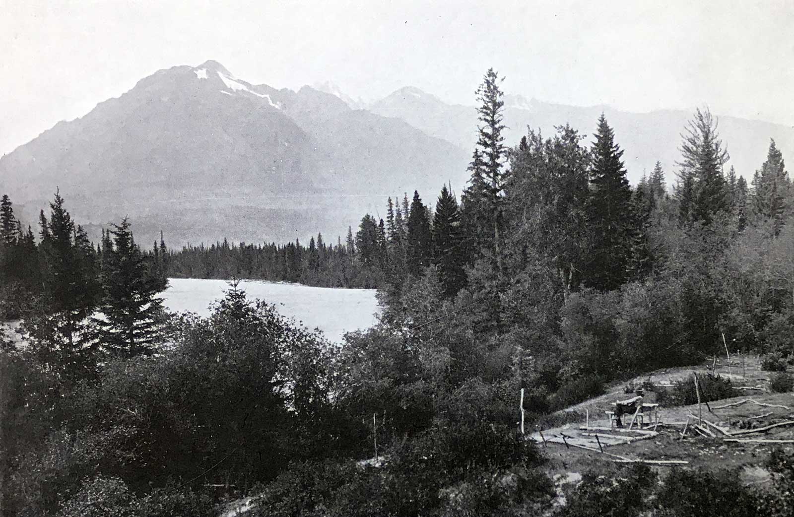
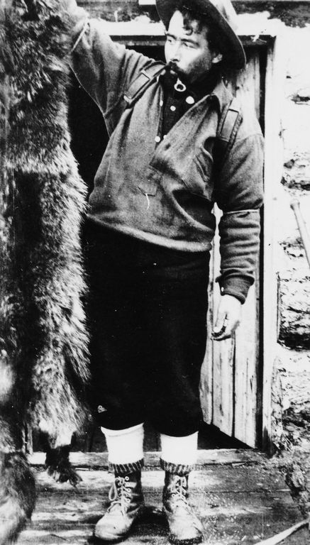
Tête Jaune Cache, showing old camping ground of fur trappers. In the distance is Mica Mountain. 1910
F.A. Talbot, New Garden of Canada
Frederick Talbot travelled through the area in 1910 with a party of Grand Trunk Pacific Railway employees. He wrote,
Certainly there is plenty of scope for development in all sorts of ways. The mountains teem with minerals of all descriptions, Keller showing us specimens of galena, gold, silver and other valuable metals, claims for which he had staked out. Mica Mountain is a great storehouse of mica, and some of the mineral obtained from it is quite noteworthy. It is white, and of good cleavage, and sheets from 32 inches square upwards can be readily obtained. If such veins are extensive, the mica mining prospect here is brilliant indeed. About twenty claims have already been staked, and the large block of this mineral which carried off a distinguished award at the last Paris Exhibition was mined on this mountain. When the neighbourhood becomes more accessible, prospectors will pour into the country, and carry out their task upon a broad, scientific basis, whereas up to the present only the surface here and there has been scratched. The wealth in the mountains hereabouts is beyond human conception, and, after the experience of Cobalt, he would be a rash man indeed, no matter what his geological and other qualifications might be, who would dare to say what could not be found.
Ontario-born Dan McPhee (b. ca. 1886) moved to the Dunster area in the early 1920s. A licensed log scaler, he worked for local mills, and sold hay to their horse-logging operations.
Mary Adeline Amelia McPhee (b. Alexandria, Ontario, 1895, d. McBride, 1962) was resident of Dunster since the late 1920s, when she came west to join her brother, Dan McPhee, at the Dunster farm.
John Alexander McNaughton (1893-1958) and his wife Bessie Agnes McNaughton (1893-1955) homesteaded in the Dunster area in 1920. John was born in Ontario, Bessie in Michigan. Around 1924 John started to work on the Canadian National Railroad section crew, and continued until 1937 when they moved to Prince Rupert for the railway. Their son Don remained on the farm.
Association with Mount McNaughton.
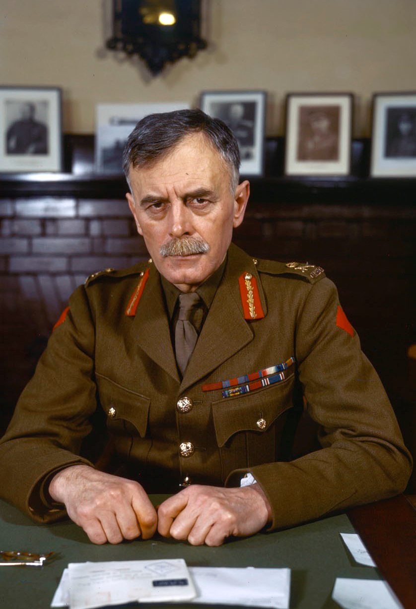
General Andrew George Latta McNaughton (1887–1966)
The former name for the man-made reservoir now called Kinbasket Lake recalls Andrew George Latta McNaughton (1887-1966), soldier and diplomat. McNaughton was born in Saskatchewan and joined the faculty of McGill University upon graduation. He had been a member of the Canadian Militia since 1909, and after the outbreak of war in 1914 he served overseas, was wounded twice, and became a brigadier-general in command of the Canadian Corps Heavy Artillery by the end of the war. He remained in military service until 1935, when he became president of the National Research Council. He returned to the army with the outbreak of World War II, and in 1942 became Commander of the First Canadian Army. After his retirement in 1944, he became Minister of Defense, and subsequently held many diplomatic posts. McNaughton was leader of those who advocated development of the Columbia River for hydro-power.
When the name McNaughton Lake was proclaimed by the British Columbia cabinet in 1973, a number of the residents of the East Kootenay area lobbied to change the name to Kinbasket Lake. After seven years of strenuous argument, the name was officially changed. The former name was widely dispersed and appears on maps and other documents.
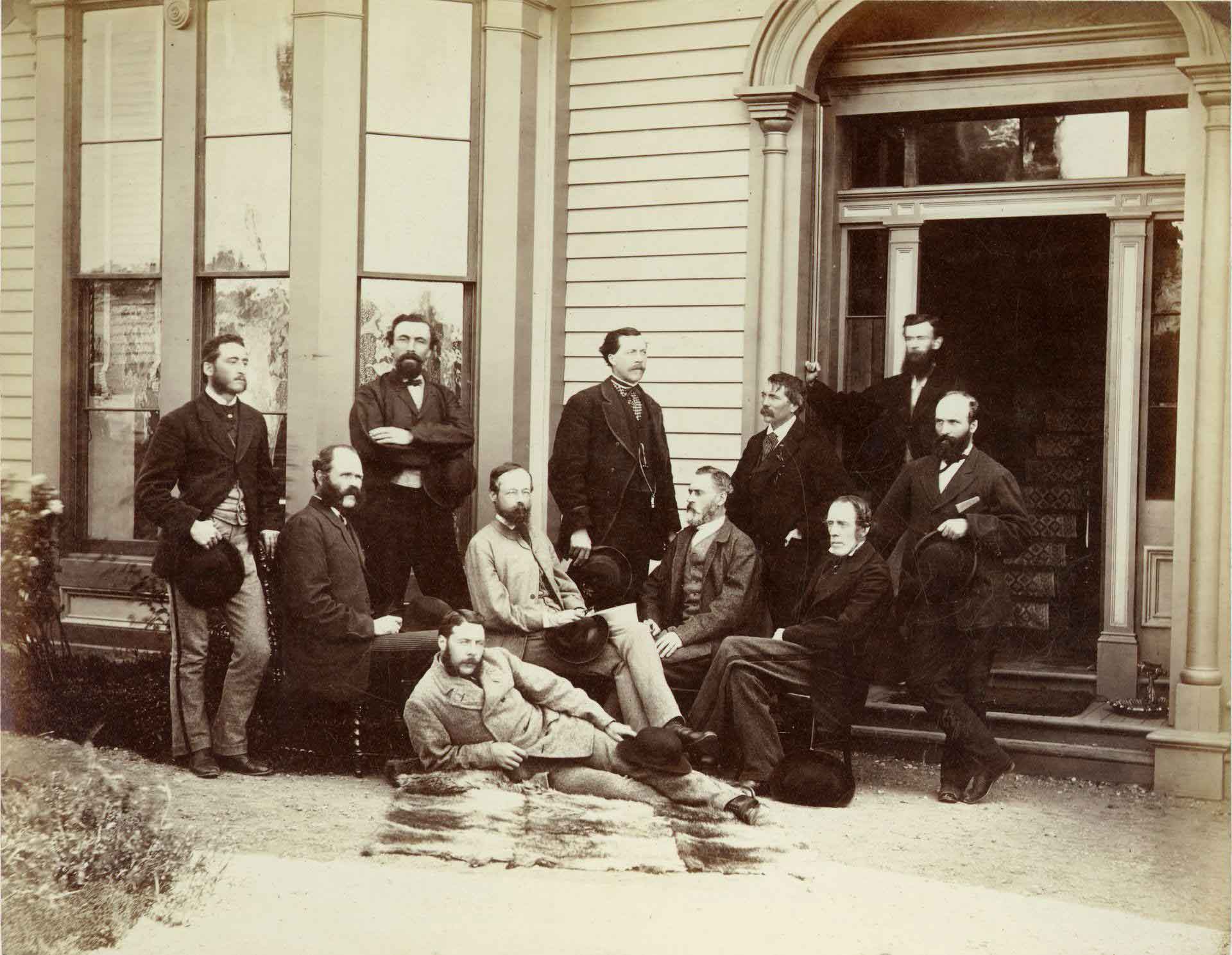
The First Canadian Pacific R.R. and Geological Survey parties for British Columbia, July 22 1871 Left to right : L. N. Rheaumis, Roderick McLennan, A. S. Hall, West West Ireland, Alfred Selwyn, Alex Maclennan, Walter Moberly, C. E. Gilette, James Richardson, — — McDonald, George Watt.
Toronto Public Library
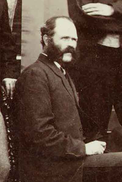
Detail: Roderick McLennan
Toronto Public Library
In 1871-72, Canadian Pacific Railway surveyors Roderick M. McLennan [1805–] and Charles Horetzky [1838–1900] made a reconnaisance from the Big Bend of the Columbia River up to the North Thompson River. McLennan left Kamloops on August 19, 1871, and in October decided to winter his party in the vicinity of Tête Jaune Cache. He built a camp four or five miles upstream from the Canoe River on what consequently came to be named Camp Creek. In 1872 he undertook an expedition to Moose Lake.
George Monro Grant mentions McLennan in his book Ocean to Ocean:
[South of Albreda] the trail was as bad as could well be, although a great amount of honest work had been expended on it. Before McCord [surveyor] had come through, it must havbe been simple impassable except for an Indian on foot, — worse than when Milton and Cheadle forced through with their one pack-horse at the rate of three miles a day; for the large Canadian party [Overlanders] had immediately preceded them, whereas no one attempted to follow in their steps till McLellan [McLennan ?] , in 1871, and in the intervening nine years much of the trail had been buried out of sight, or hopelessly blocked up by masses of timber, torrents, landslides, or debris.
“The stream here called McLennan River, its real source, is also known as Mica Creek,” reported Munday in 1925.
Fulton McKirdy, Swift Creek (Valemount)
Valemount and Area Museum
Fulton Alexander McKirdy (1874-1960) was born in Toronto, the youngest of eleven children. His father died when he was seven, and his mother moved to a farm near Wingham. In 1884 Fulton went to live in Nipigon with a brother, who operated a guiding outfit and trading post. In 1896 he started working on bridges for the Canadian Pacific Railway, and two years later came west to work on the Crow’s Nest branch. Almost the whole crew contacted typhoid fever; McKirdy was one of the few to recover.
With horses bought in Cranbrook, McKirdy and H. Dart travelled to Golden and prospected north up the Columbia River to the mouth of the Canoe River. In 1899, after a return to Golden, he prospected along the Canoe, Swift Current, and Fraser rivers. During the winter he trapped. In 1906 or 1907 he was one of the first to stake a homestead in the township of Cranberry Lake (now Valemount). McKirdy chose a field that had been burnt off for horse-pasture by the Indians who passed through the valley during summer hunting trips. When he first plowed his field, he unearthed Indian arrowheads and other artifacts. He named the creek that bordered his property “McKirdy Creek.”
In 1910 fires from the railroad right-of-way clearing and slash burning were spreading into valuable timber. McKirdy was appointed fire warden, reporting to Revelstoke until 1912, when the divisional headquarters were moved to Tête Jaune Cache. McKirdy became an assistant forest ranger in 1917 and remained in that capacity until 1940. After 1940, he became a forest fire look-out, first on Mount McLennan, Birch Island, and then on Tum Tum Mountain [in Washington state?] until his retirement at age 82 in 1956.
In 1919 McKirdy married Margaret Waite (1900-1983), who had come from Vancouver to Swift Creek in 1918 as a schoolteacher. In 1923 he was appointed justice of the peace.
Many descendants live in the Valemount area.
Two McKale brothers settled in the valley after the First World War. James R. McKale first came through on the railway survey (presumably the Grand Trunk Pacific Railway). He was a charter member of the Royal Canadian Legion, in 1927, and one of the initial trustees of Elks Lodge 247, in 1933. Jack B. McKale was a stationary fireman on the railroad up to the time of the end of steam locomotives in the mid-1950s. He ran the ice house in McBride in early 1920s, and also the local dray business. The house he built on Main Street still exists.
R. E. McKale (1910-1950), relationship unknown, is buried in the McBride cemetery.
Locally the river is known as the Blackwater Riverr.
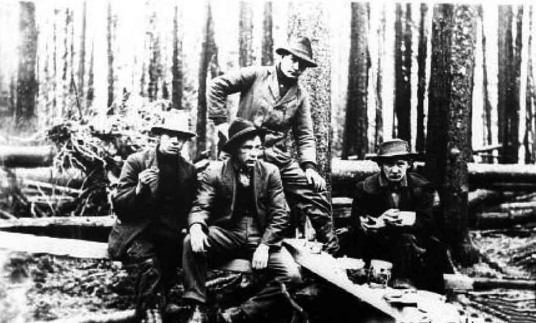
Grand Trunk Pacific Railway topographical crew of Elliot, Semple, Anderson, and McIntosh at an improvised table in the woods, 1912 (P986.5.80)
Exploration Place — Fraser Fort George Regional Museum
McIntosh Creek is shown on the 1931 Pre-emptor’s map (Tête Jaune Sheet) but not on the 1923 Sheet.
A McBride marriage registry shows “George Frederick Oettle [and] Mary Isabelle Mcintosh 1928.”(1)
The Robson Valley Chapter of the Back Country Horsemen of BC created an equestrian recreation site on Mcintosh Road (off Highway 16, 12 km west of McBride) around 2023.