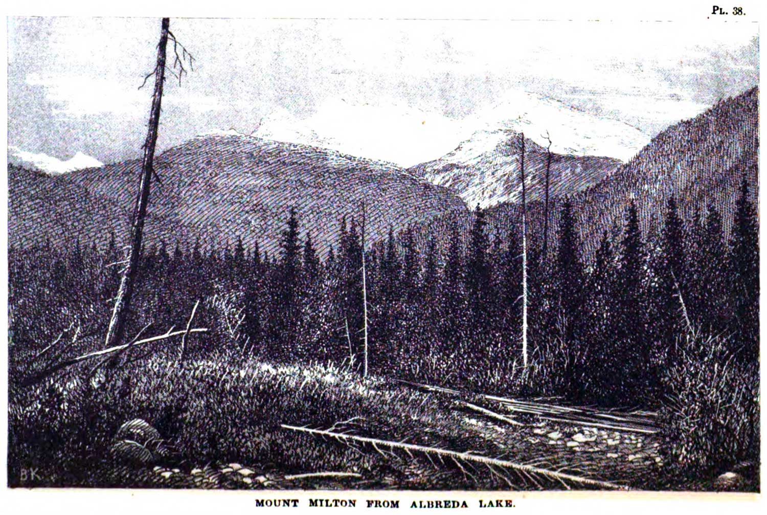
Category Archives: Place

L’Heureux Road

British Columbia. Road
Loops S off Hwy 16 at Tête Jaune
52.978 N 119.44 W GoogleGeoHack
Roads are not in the official geographical names databases

Joseph Emery L’Heureux and his wife Dorothy Edith (born Dundas, Ontario, 1896, d. 1967) settled near Mount Robson in 1936 or 1937. He was listed in the 1937 Tête Jaune voters’ list as a farmer. The L’Heureux’s started up a tourist outfitting business, and when war interrupted the venture they sold and moved near Tête Jaune where Joe had homesteaded several years before. They trapped up Swiftcurrent Creek in the 1950s. In 1969, Joe took up residence in the men’s provincial home in Kamloops.

The Robson Valley Courier newspaper published the following article when Joe left McBride:

The story of his life presents itself as a mosaic of colour and action. He has been waterboy, logger, trapper, millwright, carpenter, forester, guide jeweler, homesteader, soldier and an employee with the engineering department of the B.C. Highways. Joe is a self-made man in the truest sense of the word. Orphaned at the age of 8 when his father died (his mother died when he was 5) he was farmed out to families who agreed to keep him. At the age of 12 he decided to go on his own, and took French leave. “I got a job as waterboy in a logging camp,” he reminisces. “I determined to make something of myself, and I had only myself to rely on. I didn’t have a single relative on the North American continent.” He went to night schools while he was working days, and sometimes had saved money so that he could go to regular day schools, for a few weeks at a time, sometimes several months at one stretch. He read innumerable books on construction, so that at last he could get jobs with construction crews; he did the same with lumberman’s manuals, ant at last could do millwright work and general mechanics. He married in 1936, and he and his new bride moved to a place in the Mt. Robson area, where he built a home and set up a camp for hunters, for whom he acted as guide. He furnished horses, tents, and pack outfits. During the winter months he trapped up the Swift Current creek.

The L’Heureux’s moved back to the homestead at Tête Jaune after eight years at Robson, and he took a job with the Forest Service. He built the Forest Service buildings there. He is a veteran of the First World War and served four and a half years with the medical corps in France for two years as a first-aid man in the trenches, and later in London in the hospitals. Although the couple had no children, they enjoyed a deeply satisfying and loving life together. Mrs L’Heureux, who died a year and a half ago, was a landscape painter. They made many trips together to scenes she wished to paint. He worked in semi-precious stone, and fashioned many a lovely costume piece from jade, agate, and other jewel stones from around the world. “I hate to leave McBride”, said Joe. “I have so many friends here. But I’m coming back for visits as soon as my eyes get fixed up. I can get that done in Kamloops, one eye at a time, and I’ll be back then.”

References:

  • Robson Valley Echo. Weekly newspaper published in McBride. 1962–1967
  • Robson Valley Courier. Weekly newspaper published by Pyramid Press of Jasper from 1968–88 (1968–1988).
  • Valemount Historic Society. Yellowhead Pass and its People. Valemount, B.C.: 1984
Also see:

Evans Creek

British Columbia. Creek: Fraser River drainage
Flows E into Dome Creek
53.7 N 121.0667 W — Map 93H/11 — GoogleGeoHack
Earliest known reference to this name is 1916
Name officially adopted in 1958
Official in BCCanada

Jack Evans was a pioneer trapper and prospector who came into the area in 1895. In 1946 he was still living at Penny. He claimed to have a copy of the lost diary of Alexander Mackenzie [1764–1820], and after Evans died local people ransacked his cabin looking for a reputed cache of money.

References:

  • Runnalls, Francis Edwin [1895–1990]. A History of Prince George. Prince George: Fraser-Fort George Museum, 1946
  • Wheeler, Marilyn [1932–2016]. The Robson Valley Story. McBride, B.C.: Robson Valley Story Group, 1979
Also see:

Doré River

British Columbia. River: Fraser River drainage
Flows NE into Fraser River, NW of McBride
53.3333 N 120.2 W — Map 93H/8 — GoogleGeoHack
Earliest known reference to this name is 1910
Name officially adopted in 1965
Official in BCCanada

Doré is French for “golden.” The former Fifty Mile Creek, according to trapper Jack Damon, was given its name by a Norwegian prospector named Olson, “who found a few colors in his pan, so he called it doré, golden. He was a Norwegian Frenchman.”

Around 1911 Louis Knutson “bought the trapline on the Dore River, but I only made one trip and it was no good, it was all trapped out. Some of the boys had been in there.”

The name appears on the “Preliminary Map of the Canadian Rocky Mountains between Jarvis Pass and Yellowhead Pass” (Bulletin of the American Geographical Society, 1915), showing the route followed by Mary Lenore Jobe Akeley [1878–1966] in August 1914, with guide Donald “Curly” Phillips [1884–1938].

Doré is also another name for the Dolly Varden, but although that fish is found in this river, the name is not common in this area.

Locally the name of the river is pronounced “door.”
.

References:

  • Wheeler, Marilyn. The Robson Valley Story. McBride, B.C.: Robson Valley Story Group, 1979, p. 151
  • Wheeler, Marilyn. The Robson Valley Story. McBride, B.C.: Robson Valley Story Group, 1979
  • Jobe Akeley, Mary Lenore [1878–1966]. “Mt. Kitchi: A New Peak in the Canadian Rockies.” Bulletin of the American Geographical Society, Volume 47, No. 7 (1915):481-497, Map follows p. 496. JSTOR
  • Personal correspondence. , Jack Damon, ca. 1975
Also see:

Brûlé Hill

British Columbia. Hill
Headwaters of Fraser River
52.6122 N 118.4642 W — Map 083D09 — GoogleGeoHack
Name officially adopted in 1985
Official in BCCanada

“Brûlé” means “burnt” in French. As used in the phrase of Donald “Curly” Phillips [1884–1938], “We lost the trail and had to cut through half a mile of brulé” [burnt forest]. Pioneers called a burned out area a “bob ruly,” from the French bois brulé.

During a 1909 trip across the Yellowhead Pass with Stanley Washburn [1878–1950], Lacombe guide Fred Stephens examined what was reported to be an excellent stand of timber in the upper Fraser River valley. It was found to be completely burnt over.

The hill was named by the Alberta-British Columbia Boundary Commission party of Wheeler and Cautley in 1921.

References:

  • Washburn, Stanley [1878–1950]. Trails, Trappers and Tenderfeet in the New Empire of Western Canada. New York and London: Henry Holt, Andrew Melrose, 1912. Hathi Trust
  • Cautley, Richard William [1873–1953], and Wheeler, Arthur Oliver [1860–1945]. Report of the Commission appointed to delimit the boundary between the Provinces of Alberta and British Columbia. Part II. 1917 to 1921. From Kicking Horse Pass to Yellowhead Pass.. Ottawa: Office of the Surveyor General, 1924. Whyte Museum
  • Cautley, Richard William [1873–1953], and Wheeler, Arthur Oliver [1860–1945]. Report of the Commission Appointed to Delimit the Boundary between the Provinces of Alberta and British Columbia. Parts IIIA & IIIB, 1918 to 1924. From Yellowhead Pass Northerly. Ottawa: Office of the Surveyor General, 1925. Whyte Museum

Baker Creek

British Columbia. Creek: Columbia River drainage
Flows SW into Canoe Reach
52.2833 N 118.55 W — Map 83D/7 — GoogleGeoHack
Earliest known reference to this name is 1896
Name officially adopted in 1935
Official in BCCanada
James Baker

James Baker
Wikipedia

Named after Colonel James Baker [1830-1906], Provincial Secretary and Minister of Mines for British Columbia from 1892 to1898.

Adopted 5 March 1935 on Jasper Park south map. First labelled on a map published in 1896 (title not cited in BC files) (information provided by H. Nation, 1934).

Baker Creek is also the local name of Holliday Creek in the Fraser watershed.

References:

Also see: