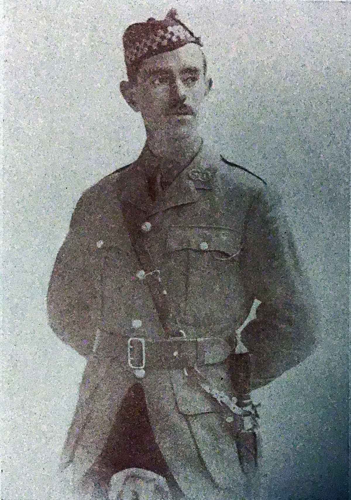
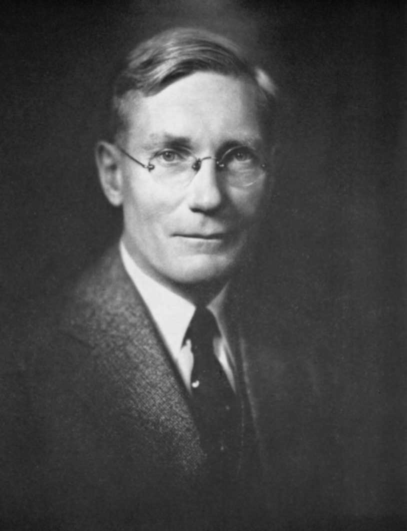
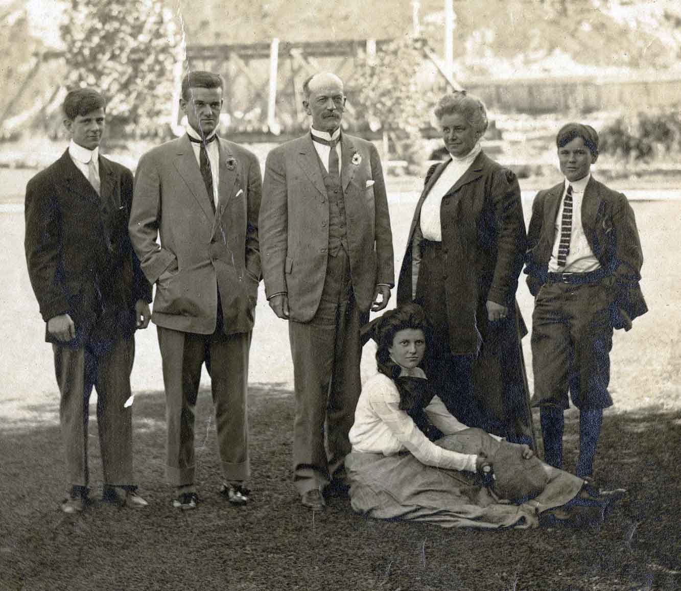
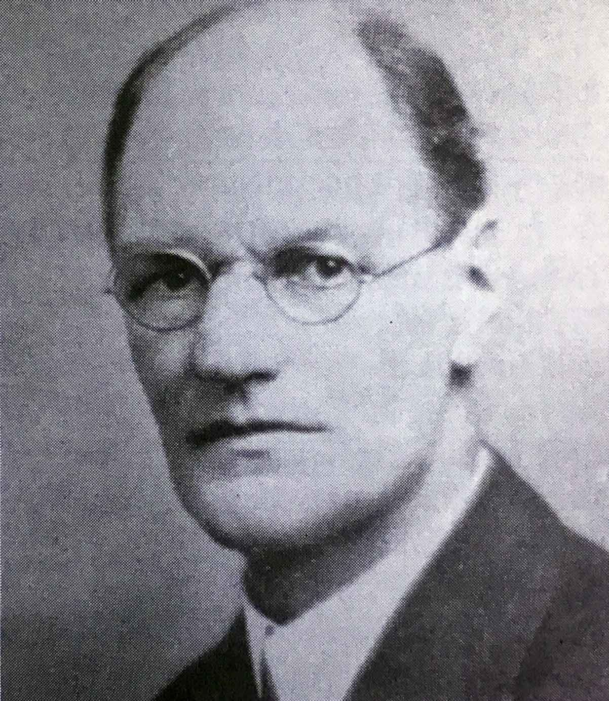
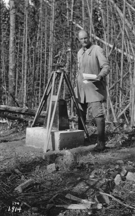
Category Archives: People

A. L. Withers

Park Warden Pete Withers, Jasper National Park Jasper-Yellowhead Museum and Archives, PA-23-28

Park Warden Pete Withers, Jasper National Park
Jasper-Yellowhead Museum and Archives, PA-23-28
Archives Canada [accessed 17 October 2025]


Jasper hockey game including Mrs. Roy Hargreaves, Mrs. Robert Blewett Sr, Mrs. Digby Harris, Mrs. Fulton, Mrs. Noble Findlay, Mrs. W. Grieves, Phyllis Lofts, Mrs. Nathan Nunn, Mrs. Fred Smith,  Miss Parks, Digby Harris, Tom Jones, V. Woodcock, H.B. Webb, Walter Huggins, Harry King, Nat Munn, Pete Withers and Paddy Bateman. 1921

Jasper hockey game including Mrs. Roy Hargreaves, Mrs. Robert Blewett Sr, Mrs. Digby Harris, Mrs. Fulton, Mrs. Noble Findlay, Mrs. W. Grieves, Phyllis Lofts, Mrs. Nathan Nunn, Mrs. Fred Smith,  Miss Parks, Digby Harris, Tom Jones, V. Woodcock, H.B. Webb, Walter Huggins, Harry King, Nat Munn, Pete Withers and Paddy Bateman. 1921
Jasper-Yellowhead Museum and Archives PA43-23 [accessed 17 October 2025]


Joe Weiss, Doug Jeffery, Vern Jeffery, Frank Burstrom and Pete Withers on Geikie Street at the start of their ski trip. 1930

Joe Weiss, Doug Jeffery, Vern Jeffery, Frank Burstrom and Pete Withers on Geikie Street at the start of their ski trip. 1930
Jasper-Yellowhead Museum and Archives [accessed 17 October 2025]

A. L. (Pete) Withers

When Peter Withers, one of the early wardens, arrived in Jasper in 1920, he owned one of the two pairs of skis in town, and during the winter of 1921 he used his skis to make his winter patrols [1].

In 1929 six Jasper men decided they would like to make a 220 mile ski trip to Banff following what is now the Icefields Parkway. During the summer they travelled by horse to several cabins in Jasper and Banff and stored bags of food for the trip. On January 15th 1930, Joe Weiss, Vern & Doug Jeffery, Frank Burstrom and Pete Withers set off. Jack Brewster was injured and had to stay behind.

When they left Jasper, it was -23 and as they travelled towards their first stop at Athabasca Falls, it got even colder.

Whenever they could, they travelled along the river because the skiing was better but, when that wasn’t possible, they had to break trail through the brush. They were able to use warden cabins for part of their trip but they also camped with a wikiup as shelter building a fire in front to keep them warm.

When they reached Sunwapta Canyon there was open water so they had to climb out and go around, then continue on past the Columbia Icefields crossing into Banff National Park.

Near Saskatchewan River Crossing they were met by two Banff wardens who had snowshoed out to look for them. The trip was a bit easier after that as they had broken trails to get them to Bow Lake and then to Lake Louise and Banff. They arrived just in time for the Banff winter carnival on February 4th [2]

On July 15, 1928, I repeated the ascent of Albreda Mountain, previously climbed in company with R. T. Chamberlin and A. L. Withers on July 18, 1924 [3].

Allen Carpé [1894–1932]

This year on March 15th [1930], three of us, Clifford White of Banff, Joe Weiss of Jasper and the writer, of Minneapolis, together with A. L. Withers of Jasper (who did not participate in the ascent of the Snow Dome, but with great courtesy accompanied us to assist with the packing of supplies) reached Camp Parker, on upper Panther creek, a tributary of the North Saskatchewan river. The two hundred odd miles that we had covered by devious route since leaving Jasper eleven days before had put us in good condition, and we eagerly awaited the clearing of the weather, which had turned stormy, for the attack on the Snow Dome [4].

— Russell Hoadley Bennett [1896–1981]

Withers is the namesake of the following places in the Mount Robson region:

Events in the Mount Robson region in which Withers was involved:

  • 1924 Chamberlin party Cariboos
References:

  • 1. Gainer, Brenda. The human history of Jasper National Park, Alberta. Manuscript report 441. Ottawa: Parks Canada, 1981. Parks Canada [accessed 28 January 2025]
  • 2. 1930 Jasper to Banff Ski Trip. 2025. Jasper-Yellowhead Museum and Archives [accessed 17 October 2025]
  • 3. Carpé, Allen [1894–1932]. “Albreda Mountain.” Canadian Alpine Journal, Vol. 16 (1927–1927):177
  • 4. Bennett, Russell Hoadley [1896–1981]. “The Ski Ascent of Snow Dome.” Canadian Alpine Journal, Vol 20 (1931):100-101

Rollin Thomas Chamberlin

Rollin Thomas Chamberlin

Rollin Thomas Chamberlin

Rollin Thomas Chamberlin
b. 20 October 1881 — Beloit, Wisconsin
d. 6 March 1948 — Chicago, Illinois

Rollin Thomas Chamberlin was a professor of geology at the University of Chicago who made numerous guided climbs in the Rocky and Selkirk Mountains in 1910, including the Lake Louise, Lake O’Hara, Field and Glacier areas. In 1924, Chamberlin, Allen Carpé [1894–1932] and A. L. (Pete) Withers made a number of first ascents in the Cariboo Mountains, including Mount Titan (now Mount Sir Wilfrid Laurier) and Mount Challenger.
Works pertinent to the Mount Robson region of which Chamberlin was author or co-author:

  • —   Rollin T. Chamberlin fonds V22. 1910–1927
  • —   “Exploration of the Cariboo Mountains of British Columbia.” Bulletin of the Geographical Society of Philadelphia, 25 (1925):59-76
Chamberlin is the namesake of the following places in the Mount Robson region:

Events in the Mount Robson region in which Chamberlin was involved:

  • 1924 Chamberlin party Cariboos
References:

  • Chamberlin, Rollin Thomas [1881–1948]. Rollin T. Chamberlin fonds V22. 1910–1927. Whyte Museum
  • Pettijohn, F. J. “Rollin Thomas Chamberlin: a Biographical Memoir.” (1970). National Academy of Sciences

Allen Carpé

Allen Carpe. Courtesy Am. A.J.

Allen Carpe. Courtesy Am. A.J. Canadian Alpine Journal 1932


Rollin T. Chamberlin, L. E. “Slim” Goodell, Allen Carpe, A. L. Withers. Photo George Burns

Rollin T. Chamberlin, L. E. “Slim” Goodell, Allen Carpe, A. L. Withers. Photo George Burns University of Chicago

Allen Carpé
b. 20 December 1894 — Chicago
d. 9 May 1932 — Mount McKinley, Alaska

Allen Carpé was an American engineer and mountaineer who was a member of the Alpine Club of Canada from 1920.

In 1924 Carpé, Rollin Thomas Chamberlin [1881–1948], and A. L. (Pete) Withers went up Tête Creek “and made some fine climbs, among them Mount Sir Wilfrid Laurier.” [1]

In 1925, he was a member of the expedition that made the first ascent of Mount Logan. He lost his life on Mount McKinley in May 1932, as the leader of a party making scientific observations relating to cosmic rays.

Carpé’s name appears with and without an accent in various documents.

Works pertinent to the Mount Robson region of which Carpé was author or co-author:

  • —   “Climbs in Cariboo Mts. and Northern Gold Range, Interior Ranges of British Columbia.” Alpine Journal, Vol. 37 (1925):63
  • —   “Albreda Mountain.” Canadian Alpine Journal, Vol. 16 (1927–1927):177
  • —   “The Cariboo Mountains – Correction.” Canadian Alpine Journal, Vol. 16 (1927–1927):177
Carpé is the namesake of the following places in the Mount Robson region:

Carpé is credited with naming the following places:

Events in the Mount Robson region in which Carpé was involved:

  • 1924 Chamberlin party Cariboos
References:

  • 1. Zillmer, Raymond T. [1887–1960]. “Explorations in the Southern Cariboos.” Canadian Alpine Journal, Vol. 27 (1939):48-61

Dalby Brooks Morkill

Dalby Brooks Morkill [1880–1955]

b. 1880 — Sherbrooke, Québec, Canada
d. 1955 — Vancouver, B.C., Canada

Morkill came to British Columbia in 1898. He received his commission as a British Columbia Land Surveyor in 1910. Morkill was employed in 1912 by the British Columbia government making surveys on the Fraser River between Horsey Creek and Holmes River. In 1913, with Alan S. Thompson, Morkill surveyed between the Goat River and Catfish Creek. Morkill worked on the Alberta-British Columbia Boundary Commission surveys north of Yellowhead Pass in the early 1920s. Subsequently Morkill surveyed in several other areas of the Province. During his last years he spent summers at his residence at Barkerville and winters in Vancouver. He was president of the Association of BC Land Surveyors in 1928.

Sources of biographical information about Morkill:

  • Andrews, Gerald Smedley [1903–2005]. Professional Land Surveyors of British Columbia. Cumulative nominal roll. Victoria: Corporation of Land Surveyors of British Columbia, 1978
  • Association of British Columbia Land Surveyors. Annual Report (1956).
Morkill is the namesake of the following places in the Mount Robson region:

Events in the Mount Robson region in which Morkill was involved:

  • 1912 Morkill Surveys
Works pertinent to the Mount Robson region of which Morkill was author or co-author:

  • —   “Report on Survey on the South Fork of Fraser River from Horse Creek to Beaver River. December 28, 1912.” Report of the Minister of Lands for the Province of British Columbia for the year ending 31st December 1912, (1913):238-240. Google Books
  • —   “Report on survey on south fork of the Fraser River, between Goat River and Catfish Creek. December 15, 1913.” Report of the Minister of Lands for the Province of British Columbia for the Year Ending 31st December 1913, (1914):423. Google Books

Samuel Prescott Fay

Samuel Prescott Fay [1884–1971]

b. 1884
d. 1971

“Pete” Fay as he was known to his friends had been a member of the [American Alpine] Club for 59 years at the time of his death last August [1971]. His qualifications for election in 1912 were four seasons in the Canadian Rockies beginning in 1906. In 1914 he joined a Smithsonian expedition which left Jasper, Alberta in June for the purposes of exploration, mapping and the collection of birds and mammals in the northern Rockies. Reports were filed with the Biological Survey in Washington. In mid-October the party met a trapper who showed them an old newspaper with reports of the first weeks of World War I of which they had no inkling. For the next three or four days they traveled non-stop to reach Hudson Hope on the Peace River.
Pete graduated from Harvard in 1907. During World War I he joined the American Field Service to drive an ambulance in France and later served with the Air Force in France and Belgium. Afterwards he was associated with an investment counseling firm in Boston for many years. Aside from two years on the Council (1930-1932), he did not take an active part in Club affairs, though he attended frequent meetings. Frail health confined him to his home for the last ten or more years.

Sources of biographical information about Fay:

  • Fay, Samuel Prescott [1884–1971]. The Forgotten Explorer: Samuel Prescott Fay’s 1914 Expedition to the Northern Rockies. Edited by Charles Helm and Mike Murtha. Victoria, B.C.: Rocky Mountain Books, 2009
  • Hall, Henry S. “Samuel Prescott Fay, 1884–1971.” American Alpine Journal, (1972) American Alpine Club
Events in the Mount Robson region in which Fay was involved:

  • 1912 SP Fay Mt. Sir Alexander
  • 1914 SP Fay Jasper to Hudsons Hope
Works pertinent to the Mount Robson region of which Fay was author or co-author:

  • —   Jasper-Yellowhead Historical Society. Album of pictures accompanying S.P. Fay journal of trip through Rockies from Yellowhead, Alberta, Pass, to Peace River at Hudsons Hope, B.C, 1914. JYHS No. 84 or 91 (1912–1914).
  • —   “Mount Alexander.” Canadian Alpine Journal, Vol. 6 (1914–1915):121
  • —   “Note on Mount Alexander Mackenzie and Mount Ida.” Alpine Journal, Vol. 36 (1924):421
  • —   The Forgotten Explorer: Samuel Prescott Fay’s 1914 Expedition to the Northern Rockies. Edited by Charles Helm and Mike Murtha. Victoria, B.C.: Rocky Mountain Books, 2009

Charles Doolittle Walcott

Walcott ready to take a panoramic view from the summit of Mount Field. Photo by Sidney S. Walcott. National Geographic Magazine, 1911.

Walcott ready to take a panoramic view from the summit of Mount Field. Photo by Sidney S. Walcott. National Geographic Magazine, 1911. Internet Archive


Standing, from left to right, is Sidney Stevens Walcott (1892-1977), Charles Doolittle Walcott, Jr. (1889-1913), Walcott, Sr., Helena Stevens Walcott (d. 1911), Benjamin Stuart Walcott (1895-1917); and seated, Helen Breese Walcott (1894-1965).

Standing, from left to right, is Sidney Stevens Walcott (1892-1977), Charles Doolittle Walcott, Jr. (1889-1913), Walcott, Sr., Helena Stevens Walcott (d. 1911), Benjamin Stuart Walcott (1895-1917); and seated, Helen Breese Walcott (1894-1965). Smithsonian Institution Archives

Charles Doolittle Walcott
b. 1850 — New York Mills, New York
d. 1927 — Washington, D.C.

Charles Doolittle Walcott was an American paleontologist and director of the Smithsonian Institution from 1907 to 1927. He made several field trips in the Canadian Rockies, discovering the Burgess Shale fossil bed in 1909, sponsoring the 1911 Alpine Club of Canada–Smithsonian Robson Expedition (he was unable to attend in person due to the death of his wife Helena in a train crash on June 11), conducting his own investigation of the Mount Robson area in 1912, and attending the 1913 Alpine Club of Canada Camp at Mount Robson where he continued his geological investigations.

Walcott was married three times — to Lura Ann Rust [1843-1876], to Helena Breese Stevens [1858-1911], and to Mary Morris Vaux [1860-1940]. By his second wife he had four children: Charles Doolittle Jr. [1889-1913], Sidney Stevens [1892-1977], Helena Breeze [1894-1965], and Benjamin Stuart [1896–1917]. Charles died while a student at Yale, and Benjamin was killed in action in France in 1917 flying for the Lafayette Flying Corps.

When Walcott traveled to the Canadian Rockies during the summer in search of fossils, often his wife and children would accompany him on his expeditions.

Works pertinent to the Mount Robson region of which Walcott was author or co-author:

  • —  and Walcott Jr., Charles Doolittle [1889–1913]. “A Geologist’s Paradise.” National Geographic Magazine, 22, no. 6 (1911). Internet Archive
  • —   Field notes : Canada, 1907, 1910, 1912-1913, 1916, and undated. 1912. Biodiversity Heritage Library [accessed 4/12/2025]
  • —   “The Monarch of the Canadian Rockies.” National Geographic Magazine, (1913):626. Internet Archive [accessed 4/2/2025]
  • —   “Cambrian Formations of the Robson Peak District, British Columbia and Alberta, Canada.” Smithsonian Miscellaneous Collections, Vol. 57, No. 12 (1913):328-343. Smithsonian Institution Archives [accessed 4/11/2025]
Walcott is credited with naming the following places:

Events in the Mount Robson region in which Walcott was involved:

    1911 ACC-Smithsonian Robson expedition
    1912 Walcott/Smithsonian at Robson
    1913 ACC Camp – Mount Robson
References:

Gabriel Franchère

Gabriel Franchère

Gabriel Franchère
Wikipedia

Gabriel Franchère
b. 3 November 1786 — Montréal, Quebec
d. 12 April 1863 — St. Paul, Minnesota

A French Canadian author and explorer of the Pacific Northwest, Franchère joined the Pacific Fur Company as a merchant apprentice, arriving at Fort Astoria on the Tonquin. After Astoria was sold to the North West Company, Franchère returned to Montréal overland in 1814. He was employed for a time by John Jacob Astor in Montréal. He wrote Narrative of a Voyage to the Northwest Coast of America, published in 1819.
Works pertinent to the Mount Robson region of which Franchère was author or co-author:

  • —   Relation d’un voyage à la Côte du Nord-Ouest de l’Amerique Septentrionale. Montréal: 1820
  • —  and Lamb, William Kaye [1904–1999], editor. Journal of a Voyage to the Northwest Coast of America, in the years 1811, 1812, 1813, and 1814. Toronto: Champlain Society, 1969. Internet Archive [accessed 3/10/2025]
Franchère is the namesake of the following places in the Mount Robson region:

Events in the Mount Robson region in which Franchère was involved:

  • 1814 Franchère crosses Athabasca Pass
References:

Paul Kane

Paul Kane Self-portrait, 1846-1848

Paul Kane
Self-portrait, 1846-1848
Wikipedia


Jasper House East Side Rocky Mountains Paul Kane. Field sketch, November 7, 1847

Jasper House East Side Rocky Mountains
Paul Kane. Field sketch, November 7, 1847
Wikipedia


Paul Kane, “Boat Encampment,” Hudson’s Bay Company voyaguers, oil on canvas, 1849–1856

Paul Kane, “Boat Encampment,” Hudson’s Bay Company voyaguers, oil on canvas, 1849–1856
Royal Ontario Museum ROM2009_11209_41

Paul Kane
b. 3 September 1810 — Mallow, County Cork, Ireland
d. 20 February 1871 — Toronto, Ontario, Canada

Kane was an Irish-born Canadian painter, famous for his paintings of First Nations peoples in the Canadian West and other Native Americans in the Columbia Departmentof the fur trade.

A largely self-educated artist, Kane grew up in York, Upper Canada (now Toronto), and trained himself by copying European masters on a “Grand Tour” study trip through Europe. He undertook two voyages through the Canadian northwest in 1845 and from 1846 to 1848. The first trip took him from Toronto to Sault Ste. Marie and back. Having secured the support of the Hudson’s Bay Company [founded 1670 – dissolved 2025], he set out on a second, much longer voyage from Toronto across the Rocky Mountains.

On October 6, 1846, Kane left Edmonton for Fort Assiniboine, where he again embarked with a canoe brigade up the Athabasca River to Jasper House, arriving on November 3. Here he joined a large horse troop bound west, but the party soon had to send the horses back to Jaspers House and continue on snowshoes, taking only the essentials with them, because Athabasca Pass was already deeply snowed in that late in the year. They crossed the pass on November 12 and three days later joined a canoe brigade that had been waiting to take them down the Columbia River to Fort Vancouver (present-day Vancouver, Washington) and Fort Victoria (present day Victoria, British Columbia).

On both trips Kane sketched and painted First Nations and Métis peoples. Upon his return to Toronto, he produced more than one hundred oil paintings from these sketches. The oil paintings he completed in his studio are considered a part of the Canadian heritage, although he often embellished them considerably, departing from the accuracy of his field sketches in favour of more dramatic scenes.

Works pertinent to the Mount Robson region of which Kane was author or co-author:

  • —   Wanderings of an artist among the Indians of North America. From Canada to Vancouver’s Island and Oregon through the Hudson’s Bay Company’s territory and back again. London: Longman, Brown, 1859. Internet Archive [accessed 3/10/2025]
Kane is the namesake of the following places in the Mount Robson region:

Events in the Mount Robson region in which Kane was involved:

  • 1846 Kane through Athabasca Pass
References:

Richard William Cautley

Richard William Cautley Photo from

Richard William Cautley
Photo from “Compass to Satellite” by W.D. Stretton p. 42 (Canadian Surveyor vol 31 no 4) Alberta’s Land Surveying History


R. W. Cautley at Monument 95F 1914 Library and Archives Canada 4876261

R. W. Cautley at Monument 95F 1914
Library and Archives Canada 4876261

Richard William Cautley, D.L.S., A.L.S., C.E.
b. 5 September 1873 — Petworth, Sussex, England
d. 13 September 1953 — Victoria, B.C.

Cautley was the original Alberta and later also the Dominion representative on the Alberta-British Columbia Boundary Commission, which conducted surveys in the Mount Robson region from 1917 to 1924.

The Alberta boundary commissioner was responsible for surveying the boundary in the passes. Cautley was an experienced surveyor, having obtained his first commission in 1896. Although Cautley was responsible for the surveys in the passes, the location of the monument positions was decided collectively by the Commission, which included as British Columbia commissioner Arthur Oliver Wheeler [1860–1945].

Cautley andWheeler wrote the reports for the Commission and supervised production of the maps After 1924 Cautley went to Ottawa with the Department of the Interior and was responsible for the survey of many of the national park sites in the maritime provinces.

He came to Canada at the age of 17 and became attached to a firm of surveyors in British Columbia. Later, he went north into the Klondike at the time of the gold rush and was engaged in the recording and inspection of mineral claim surveys. Upon termination of the gold rush, his footsteps led to Edmonton where he formed the land surveying firm of Cautley and Cote. Later, he went into partnership with his brother Reginald Hutton Cautley. Cautley was a charter member of the Alberta Land Surveyors’ Association, and was the Association’s president in 1914.

Works pertinent to the Mount Robson region of which Cautley was author or co-author:

  • —  and Wheeler, Arthur Oliver [1860–1945]. Report of the Commission Appointed to Delimit the Boundary between the Provinces of Alberta and British Columbia. Part I: From 1913 to 1916. Ottawa: Office of the Surveyor General, 1917
  • —   “Characteristics of passes in the Canadian Rockies.” Canadian Alpine Journal, Vol. 12 (1921–1922):117-123
  • —  and Wheeler, Arthur Oliver [1860–1945]. Report of the Commission appointed to delimit the boundary between the Provinces of Alberta and British Columbia. Part II. 1917 to 1921. From Kicking Horse Pass to Yellowhead Pass.. Ottawa: Office of the Surveyor General, 1924. Whyte Museum
  • —  and Wheeler, Arthur Oliver [1860–1945]. Report of the Commission Appointed to Delimit the Boundary between the Provinces of Alberta and British Columbia – Part III – from 1918 to 1924. Atlas. Ottawa: Office of the Surveyor General, 1925
  • —  and Wheeler, Arthur Oliver [1860–1945]. Report of the Commission Appointed to Delimit the Boundary between the Provinces of Alberta and British Columbia. Parts IIIA & IIIB, 1918 to 1924. From Yellowhead Pass Northerly. Ottawa: Office of the Surveyor General, 1925. Whyte Museum
  • —   High lights of memory : incidents in the life of a Canadian surveyor. 1950. Whyte Museum
Events in the Mount Robson region in which Cautley was involved:

  • 1917 Boundary Comission Survey Yellowhead Pass
  • 1923 Boundary Comission Survey completed to Robson
  • 1924 ACC Camp – Mount Robson
References:

  • Whittaker, John A., editor. Early Land Surveyors of British Columbia (P.L.S. Group). Victoria, B.C.: The Corporation of Land Surveyors of the Province of British Columbia, 1990
  • Sherwood, Jay. Surveying the Great Divide. The Alberta/BC Boundary Survey, 1913-1917. Qualicum Beach, BC: Caitlin Press, 2017
  • Olsson, Gordon, A.L.S. The Survey of the Alberta-British Columbia Boundary 1913-1924. 2024. Alberta Geomatics Historical Society [accessed 8 April 2025]

David Douglas

David Douglas, Scottish botanist

David Douglas, Scottish botanist
Wikipedia [accessed 15 October 2025]

David Douglas
b. 25 June 1799 — Scone, Scotland
d. 12 July 1834 — Mauna Kea, Hawaii

David Douglas was a Scottish botanist, best known as the namesake of the Douglas fir and for estimating the heights of Mount Brown and Mount Hooker to be about 17,000 feet above sea level. He worked as a gardener, and explored the Scottish Highlands, North America and Hawaii, where he died [1].

Douglas made three separate trips from Britain to North America. His first trip, to eastern North America, was from June to late autumn of 1823. The second was to the Pacific Northwest, from July 1824 returning October 1827. On 1 May 1827, Douglas crossed the Athabasca Pass:

After breakfast, about one o’clock, being well refreshed, I set out with the view of ascending what seemed to be the highest peak on the north. The height from its apparent base exceeds 6000 feet, 17,000 feet above the level of the sea. After passing over the lower ridge of about 200 feet, by far the most difficult and fatiguing part, on snow-shoes, there was a crust on the snow, over which I walked with the greatest ease. A few mosses and lichens, Andreae and Jungermanniae, were seen. At the elevation of 4800 feet vegetation no longer exists not so much as a lichen of any kind to be seen, 1200 feet of eternal ice. The view from the summit is of that cast too awful to afford pleasure nothing as far as the eye can reach in every direction but mountains towering above each other, rugged beyond all description; the dazzling reflection from the snow, the heavenly arena of the solid glacier, and the rainbow-like tints of its shattered fragments, together with the enormous icicles suspended from the perpendicular rocks ; the majestic but terrible avalanche hurtling down from the southerly exposed rocks producing a crash, and groans through the distant valleys, only equalled by an earthquake. Such gives us a sense of the stupendous and wondrous works of the Almighty.

This peak, the highest yet known in the northern continent of America, I felt a sincere pleasure in naming MOUNT BROWN, in honour of R. Brown, Esq., the illustrious botanist, no less distinguished by the amiable qualities of his refined mind. A little to the south is one nearly of the same height, rising more into a sharp point, which I named MOUNT HOOKER, in honour of my early patron the enlightened and learned Professor of Botany in the University of Glasgow, Dr. Hooker, to whose kindness I, in a great measure, owe my success hitherto in life, and I feel exceedingly glad of an opportunity of recording a simple but sincere token of my kindest regard for him and respect for his profound talents.” [2]

His third and final trip started in England in October 1829. On that last journey he went first to the Columbia River, then to San Francisco, then in August 1832, to Hawaii. Douglas died under mysterious circumstances while climbing Mauna Kea in Hawaii at the age of 35 in 1834. He apparently fell into a pit trap where he was mauled to death by a bull.

Athelstan George Harvey [1884–1950] published a biography in 1947 [3].

Works pertinent to the Mount Robson region of which Douglas was author or co-author:

  • —   Journal kept by David Douglas during his travels in North America 1823-1827, together with a particular description of thirty-three species of American oaks and eighteen species of Pinus, with appendices containing a list of the plants introduced by Douglas and an account of his death in 1834. Royal Horticultural Society, 1914. Internet Archive [accessed 3/10/2025]
Douglas is credited with naming the following places:

Events in the Mount Robson region in which Douglas was involved:

  • 1827 Drummond and Douglas meet at York factory waiting for boats home
  • 1827 David Douglas Athabasca pass
  • 1832 Douglas back in Columbia region
  • 1834 Douglas killed in Hawaii, Drummond in Cuba.
References:

  • 1. Wikipedia. David Douglas
  • 2. Douglas, David [1799–1834]. Journal kept by David Douglas during his travels in North America 1823-1827, together with a particular description of thirty-three species of American oaks and eighteen species of Pinus, with appendices containing a list of the plants introduced by Douglas and an account of his death in 1834. Royal Horticultural Society, 1914, p. 71. Internet Archive [accessed 10 March 2025]
  • 3. Harvey, Athelstan George [1884–1950]. Douglas of the Fir: A Biography of David Douglas, Botanist. Cambridge: Harvard University Press, 1947