SW of Legrand, E of Milk River
53.2589 N 120.5806 W — Map 093H07 — Google — GeoHack
Name officially adopted in 1965
Official in BC – Canada
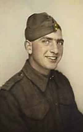
Trooper Frank Halvorson
Canadian Virtual War Memorial
Named to remember Trooper Frank Halvorson, H45935, from McBride; serving with the 27th Armoured Regiment, Sherbrook Fusiliers, RCAC, when he was killed in action 29 October 1944.
Frank Halvorson was son of John and Ann Halvorson, of McBride. He was born in Edmonton on November 24, 1918,and enlisted July 3, 1940, at Port Arthur, Ontario.
The Sherbrooke Fusiliers Regiment was formed as an infantry unit in 1940. In 1942 it was converted to an armoured regiment and renamed 27th Armoured Regiment (Sherbrooke Fusilier Regiment) and joined 4th Armoured Brigade. They later transferred to the 2nd Canadian Armoured Brigade and saw action in Normandy and across Western Europe.
Halvorson is buried at Bergen-op-Zoom Canadian War Cemetery, Netherlands, grave 8, D, 7. Most of the soldiers buried at Bergen-op-Zoom Canadian War Cemetery lost their lives in the fighting north of Antwerp during the Battle of the Scheldt, as the 2nd Canadian Infantry Division, with support from the 4th Canadian Armoured Division, worked to clear the right (north) bank of the Scheldt estuary of German forces. Bergen-op-Zoom Canadian War Cemetery contains 1,118 Commonwealth burials of the Second World War, 31 of which are unidentified.
- British Columbia Geographical Names. Halvorson, Mount