Feature type: provincial park
Province: British Columbia
Location: Swift Creek, near Valemount
Province: British Columbia
Location: Swift Creek, near Valemount
Named is association with Mount Geikie.
Last summer another party, this time from the United States, Professor E. W. D. Holway, whose name figures prominently in Selkirk exploration, and Dr. A. J. Gilmour set out for the same goal and on August 5 reached [the summit of Mount Geikie], over the northwest arête, which they followed to a very steep cornice overhanging the perpendicular north face of the mountain. Several minor peaks at the hitherto unexplored sources of Geikie Creek were also ascended in the twelve days’ trip.
— Fay 1915
The feature was named by the Alberta-British Columbia Boundary Commission in 1921.
The feature was named by the Alberta-British Columbia Boundary Commission in 1921, in association with Gateway Peak.
While on the summit of Mt. Postern I made an interesting discovery, namely, that Gateway Glacier as shown on the Interprovincial Boundary Sheet No. 28, is not glacier at all, but a lake! This lake, which is of a beautiful jade colour appeared to be quite a bit larger than Icefall Lake and will, I hope, eventually take its place on the map as “Jade Lake.” It should be mentioned that Jade Lake lies a in a deep cirque between Mts. Portcullis and “Warden” and is invisible from any of the survey stations.
— Wates and Gibson
In 1911, Albreda postmaster Ernest C. Cox entered in his diary, “Saw Craig, the fire warden, Ed Garrett and Kennedy.” Edmund Garrett [1879–1958] built a house west of McBride in the 1910s (it burned down in 1982). He accompanied Roy Hargreaves on a 1932 hunting trip that included Hollywood producer Darryl Zanuck. Garrett was the first grader operator in the McBride highways district; he operated the blade while another man drove the four-horse team. Garrett married Minnie Redman (1873–1966), who had come to McBride as governess for the local superintendent of the Grand Trunk Pacific Railway. “Minnie was a weaver, a flowery writer who specialized in obituaries, and a master of elocution,” recalls Sadie Frye (Monroe). Ed and Minnie are buried in the McBride cemetery.
Originally called Locus Peak.
Alan V. (1907–1960) and Vivian (born 1913) Frear started a dairy farm in 1932, at the end of what is now Museum Road. Alan and son Alan E. (1937-1960) were killed in a mudslide during construction of the West Twin highway bridge.
Simon Fraser
The name was officially adopted by the Geographic Board of Canada in 1910, as long-identified on maps and in journals. The name was re-approved in in 1915 to specifically identify the Fraser River as the main channel sometimes known as the South Fork Fraser River (the portion between Yellowhead Lake and Prince George), the former North Fork Fraser River being the current McGregor River.
The first European to mention the Fraser River was Alexander Mackenzie [1764–1820] during his journey to the Pacific in 1793. On a map printed with his Voyages in 1801, Mackenzie called the river “Tacoutche Tesse, or Columbia River.” The Spanish explorers never found their way up the mouth of the Fraser, but in 1791, finding evidence that they were near the mouth of a major river, they named it “Rio Floridablanca” in honor of the prime minister of Spain.
The Fraser River was also known in the early days as the New Caledonia River. It was named after Simon Fraser in 1813 by David Thompson [1770–1857] (the Thompson River was given its name by Fraser).
“Fraser River / Fleuve Fraser” is among the 75 “Pan-Canadian names,” large and well-known Canadian features and areas designated in Treasury Board Circular 1983-58 to require presentation in both official languages of Canada on federal maps. In French, a fleuve is a river that flows into an ocean or sea.
Possibly named for William Wasborough Foster [1872-1954], a major-general in the Canadian Army and accomplished alpinist, member of the party to make the official first ascent of Mount Robson in 1913. Foster immigrated to Canada in 1894 to work for the Canadian Pacific Railway before becoming B.C.’s deputy minister of public works in 1910.
The British Columbia Archives has a photograph of the Foster Creek rapids on the Columbia River taken in 1915 during a canoe trip made in by John Preston Forde, a civil engineer with the C.P.R., assistant Captain F. P. Armstrong, and 15 year old G. B. Forde. The purpose of the trip was to examine the possibilities of navigation on the Columbia. The party travelled from Robson, B.C., to Beverly, Washington, by canoe and then onwards by train and steamer to Astoria. However, it’s unclear whether Robson in this case refers to the mountain or the community at the junction of Columbia and Kootenay rivers, opposite Castlegar. Forde was assistant public works engineer for B.C. from 1911 to 1912, while W. W. Foster was deputy minister.
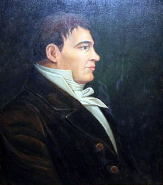
Hon. George E. Foster
Photo: Libraries and Archives Canada
New Brunswick Literary Encyclopedia
This Canadian Northern Railway station was named in the 1920s for senator Sir George Eulas Foster [1847–1931], then Minister of Trade and Commerce. On the eve of the general election in 1917, Foster was struck by a railway engine at Union Station in Toronto and left with a broken shoulder blade, a broken collar bone, and four broken ribs. His determination even as an injured 70-year-old was in evidence as he resumed his duties from his sickbed and returned to the House within months.
Mt. Robson-CNoR
1st location 1915 Renamed Foster
2nd location 1922Even at an obscure station such as Mt. Robson, BC, train time could be a major event. A trio of adventurers awaits the arrival of the eastbound passenger train; Mt. Robson was a world-famous centre for packing and hiking and for mountaineers seeking to conquer the tallest mountain in the Canadian Rockies. The others, lacking baggage of any kind, could be the family members of a local section crew going into Redpass to shop, or they could be from the Robson Ranch — a resort just down the valley — waiting to exchange mail. Mt. Robson station was originally located about three mile east of here, where the CNoR erected a Type C depot in 1915. A disastrous snow slide on 26 February 1921 covered the tracks just beyond the tram in this photograph, killing three people. As a result, in conjunction with the construction of a snow shed, in 1922 the CNR established a new station at this location, naming it Mt. Robson and re-naming the former point Foster. A Standard Portable Station and a Standard Freight and Passenger Shelter were installed at the new station in 1922. The local operator and a watchman who patrolled the tracks on either side of the new snow shed ensured that the tragic results of the 1921 snowslide would not recur. Still prominent on the Mt. Robson station here is the cantilever bracket for the train-order signal, which has been removed. The Portable Station was removed in the 1940s, leaving only the shelter. Until October 1963, employee operating timetables instructed passenger trains to stop for five minutes to let on-board patrons catch a glimpse of the station’s namesake mountain, to the right and behind the photographer.
— Bohi 2002