: Peace River drainage
Not currently an official name.
Not currently an official name.
This appears on:
Wyld map North America 1823
Wyld map North America 1823
Ernest Voorhis [1859–1933] fort number 326 [1].
North West Co. fort on left bank of Peace river just below mouth of Smoky river, a few miles below Fort of the Forks. Was well-built- with a stockade and 5 bastions. After the union of 1821 the Hudson’s Bay Co. operated this fort for some time. It appears on their 1857 map No.8 also map No. 3. Built in 1791. An X.Y. Co. fort was built nearby.
Listed as fort number 275 in Ernest Voorhis [1859–1933], Historic Forts [1] :
A small North West Co. post west of Yellowhead Pass on present Moose lake near Tête Jaune Cache, enlargement of Fraser river.
From Merk’s introduction to Fur Trade and Empire:
The accompanying journal of George Simpson [1792–1860] is a memoir of trade and of empire. The author was Governor of the Hudson’s Bay Company Territories in America, and as such, director of the economic life of the greater part of what is now the Dominion of Canada and the Pacific Northwest of the United States. At the time of writing this journal he was primarily interested in the task of rehabilitating the fur trade of one section of this vast empire, the Oregon Country, stretching westward from the Rocky Mountains to the sea and from California to Alaska. His account opens with his embarkation in a North canoe on Hudson Bay bound for the Pacific and for the work of reorganizing this trade. He gives a lively narrative of his swift journey across the continent, with comments interspersed on the state of trade along his route. In Oregon the record becomes a memoir of Indian life, of trade problems, of the slashing reforms by which he revived a demoralized and profitless industry, and of his plans for holding possession of the country against any future competition of Americans.…
The Oregon Country, which is the central theme of the document, was in 1824-25 a region in dispute. Not only was it contended for by Great Britain and the United States, but it was claimed also by the Russian Czar, though he was preparing in 1824-25 to give up such rights as he had there for recognition of his sovereignty north of the parallel of 54° 40′. Governor Simpson was ambitious to win the Oregon Country, or as much of it as possible, for Great Britain and for the Hudson’s Bay Company.
Peace came by way of a coalition agreement entered into in London in 1821. In the merger the Hudson’s Bay Company retained its identity; it took over the assets of the North West Company, evaluated like its own at €200,000, and to finance the consolidation doubled its outstanding stock. The charter and the ancient privileges of the Hudson’s Bay Company remained undisturbed. To the privileges a princely addition was made. The British government as a reward for the peace and as a means of preventing any future outbreak of war conferred upon the reorganized Company, under an act of Parliament of 1821, exclusive trading rights for twenty-one years in all that part of British North America lying between Rupert’s Land and the Rocky Mountains, and, in addition, the sole British trading rights in the whole of the Oregon Country. Thus the entire area which is now the Dominion of Canada excepting only the valley of the St. Lawrence and the maritime provinces was, after 1821, under the control of the Hudson’s Bay Company, either as proprietor or as possessor of exclusive trading rights, and besides the Company held sole British rights of trade in all of what is now the Pacific Northwest of the United States.
The Company divided this empire, for purposes of trade, into four great Departments. Of these the Northern Department of Rupert’s Land was the largest and most important, embracing the area lying between the Arctic Ocean on the north, the United States on the south, Hudson Bay on the east and the Rocky Mountains on the west, together with New Caledonia west of the mountains. The Southern Department extended from James Bay southward to the provinces of Upper and Lower Canada, and also East Main, the eastern slope of Hudson Bay. The Montreal Department comprised whatever business was done in the Canadas, and included the Kings Posts, and at a later date part of Labrador. The Columbia Department embraced the valley of the Columbia and after 1825 the province lying to the north of it — New Caledonia. Departments such as these were principalities! (1)
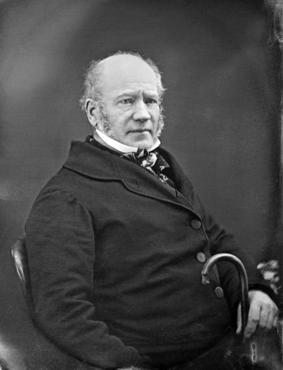
Sir George Simpson
Photo by William Notman, 1850
Wikipedia
George Simpson
b. 1792 — Loch Broom, Ross-Shire, Scotland
d. 7 September 1860 — Lachine, Canada
George Simpson who stood at the head of this great field organization [Hudson’s Bay Company] was in 1821 a man with a future rather than a past. He was the illegitimate son of George Simpson, born at Loch Broom in Ross-shire, Scotland, in 1792. Of his early life little is known except that he was given a fair education, was brought to London in 1809, and as a clerk entered the employ of a firm engaged in the West India trade. His native heath in the early nineteenth century was a nursery ground for North American fur-trade leaders, but his own entrance into the industry was the result of his having attracted the favorable notice of Andrew Colvile, an influential member and later governor of the Hudson’s Bay Company. In the spring of 1820 he was sent by the Hudson’s Bay Company to the Athabasca Country to acquire experience in the Indian trade, and there he spent the winter of 1820-21. At that time the war with the North West Company was in the litigation stage, and Governor Williams was under indictment in the courts of Lower Canada. In order to be prepared for the contingency of his removal to Quebec, the Hudson’s Bay Company, in November, 1820, appointed Simpson governor locum tenens. At the coalition, at the age of twenty-nine, he was promoted to joint governorship, with Williams, of the Company Territories, with special charge of the Northern Department of Rupert’s Land including the Department of the Columbia. By 1826 he was governor-in-chief of all the Hudson’s Bay Company Territories in America.
To be governor of the Northern Department of Rupert’s Land in 1821 was to be brought face to face with harassing problems of post-war reconstruction. Rupert’s Land was strewn with the wreckage of battle. There was material wreckage in the form of exhaustion of fur preserves, the duplication of trading posts and the multiplication of equipment and men. More difficult to cope with was the psychological wreckage, mutual bitterness and hate of subordinates of the old companies now brought together in the coalition, habits of drunkenness which competition had fostered among the Indians, relaxed habits of discipline among servants, and the propensity to waste and extravagance formed by the whole fur-trading community. These were the rehabilitation problems of the new governor and they were a test of his quality.
He came to his task with an intellectual equipment that promised much for his success. He had, to be sure, only scant experience in Rupert’s Land, but that was an element of strength rather than of weakness in 1821 since it had as its corollary freedom from the rancors of the war. Indeed, it was one of the chief reasons for appointing him rather than his senior colleague to the great Northern Department. He combined with a sure judgment an exterior of affability that enabled him to heal old wounds and to reconcile men to a new order. As an administrator his talents were exceptional. He had the imaginative vision of a Clive; he drew his plans on a scale that was continental. With vision he combined a grasp of detail that was extraordinary. There was no element of the fur trade from the Athabasca Country to the Sandwich Islands, from Hudson Bay to the steppes of Siberia, that he did not acquaint himself with by personal visit. He was a dynamo of energy, tireless at his work, whether at his desk or on the march. His journeys were famous for their speed; on the present voyage, though he took a route that was unfavorable in passing from Hudson Bay to the Columbia and lost many days by halts for business, he cut the record for the distance from 104 days to 84. On his return, to save time in an emergency, he made a perilous and exhausting overland march from Carlton to the Red River Settlement. His party, when it met relief within a half-day’s march of the Settlement, was half famished and utterly spent, but not the Governor. Without pausing for food or rest he threw himself upon a horse brought by the relief party and galloped off to his duties at Fort Garry. He put the spurs as remorselessly to his subordinates, high and low, as to himself. There is an unsubstantiated legend, which used to circulate in the Red River Colony, that on one occasion his goading drove one of his favorite voyageurs to the point of seizing him by the collar, lifting him into the water, and holding him there until he promised to relent his pace.
Also see [2]
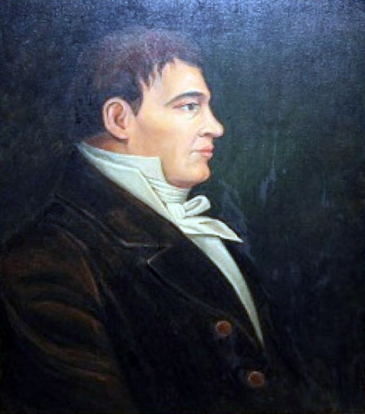
Simon Fraser
Simon Fraser
b. 20 May 1776 — Mapletown, New York, USA
d. 18 August 1862 — St. Andrews West, Ontario
During May and June of 1808, with a party of nineteen French Canadian voyageurs, two clerks, and two Native Americans, Fraser made his journey down the Fraser River from just upstream of present-day Prince George to present-day Vancouver. It was a bitter disappointment for him to discover that the river was not the Columbia, and that it was not a practical canoe route to the coast.
In 1813 the North West Company established a post on Brûlé Lake as a “provision depot with the view of facilitating the passage of the mountains through Athabasca Pass.” By 1817, Jasper House was on the west shore of the lake, according to Ross Cox [1793–1853].
James Hector [1834–1907] wrote of his explorations in January 1859:
At three o’clock we reached the point where the Athabasca emerges from “Lac à brulé,” which lies at the base of the mountains, which rise from its western shore at least 3,000 feet. This lake was swept by such a violent wind from the south that we could hardly make way against it over the smooth ice. Its eastern shore is formed of immense sand-hills; and as we reached its upper part we found the ice so covered with the same material that the dogs could hardly pull the sleds.
Frederick Arthur Ambrose Talbot [1880–1924] makes the following comments on the construction of the Grand Trunk Pacific Railway in the area around 1911:
Here and there the builders were confronted by tremendous difficulties, such as in the vicinity of Brule Lake, at the entrance to the Rockies. This sheet of water is in reality an enlargement of the Athabaska River, the southern bank being deeply indented, and the soil a light sand. The railway skirts the southern bank, and in order to preserve the grade, heavy embankment work was requisite. The remarkable feature of this sheet of water is that it is always swept by a wind which at times assumes the fury of a gale. Even at the time of my arrival in mid- summer, when the air a few hundred yards inland was oppressively still, a keen breeze played across this lake. This peculiarity is attributed to the fact that the expanse lies in the path of the funnel formed by the passage of the river through the mountains, and through this constricted channel the wind is forced to make its way like a huge draught, to expend its force upon this area of water. Be that as it may, its existence resulted in a pretty battle between Nature and the engineers, and the struggle for supremacy lasted a long time.
As fast as the sand was excavated from a cutting and dumped to form an embankment, it was picked up by the wind and driven back again. On this short length of line around the lake there are two notable pieces of work, a cutting from which 87,000 cubic yards were removed, and an embankment built up of 117,000 cubic yards. The broad, high surface of the latter suffered from the full force of the wind, which picked up the sand in dense clouds and drove it irresistibly forward into the cut. At last the engineers erected a series of screens which deflected the eddying, circling wind laden with dust, the latter falling helplessly against these obstructions, and in time forming a natural protection to the cutting. So far as the slope of the embankment was concerned, the expedient of protect- ing its surface with scrub was adopted and found to be highly successful.
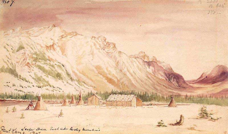
Jasper House East Side Rocky Mountains
Paul Kane. Field sketch, November 7, 1847 Wikipedia
![‘Jasper House.’ Outlying trading huts of the Hudson Bay Company, near foot of the Leatherhead Pass, Rocky’s. Graves of Company’s Servants, murdered by Indian [1872]](/wp-content/uploads/2024/11/rylatt-jasper-house.jpg)
‘Jasper House.’ Outlying trading huts of the Hudson Bay Company, near foot of the Leatherhead Pass, Rocky’s. Graves of Company’s Servants, murdered by Indian [1872] [1]
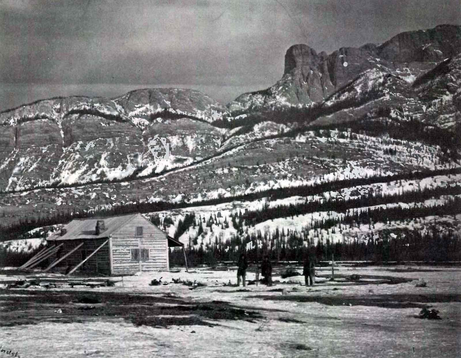
Jasper House and Roche Miette, Sandford Fleming expedition. Photo: Charles Horetzky, 1872 [2]
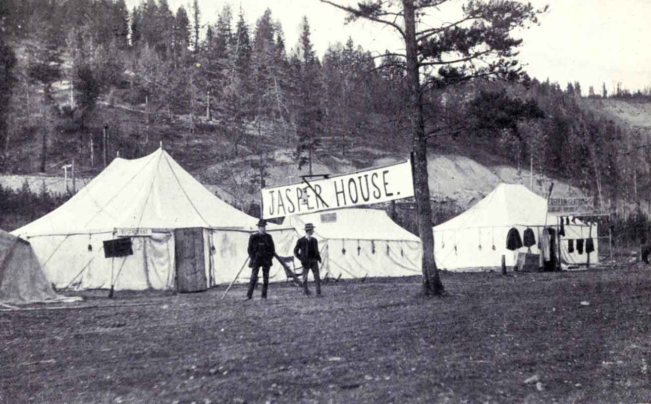
Jasper House. A “bush inn,” or stopping-place, where meals are served at two shillings per time. R. C. W. Lett photo, ca. 1911 Talbot, Making Good in Canada, p. 103 [accessed 15 February 2025][3]
The situation of Jaspers House is beautifully Wild and romantic, on the borders of the Athabasca River which here spreads itself out into a small Lake surrounded by Lofty Mountains. This is a temporary summer post for the convenience of the Columbians in crossing; the Winter Establishment of last Year on the borders of the Smoky River about 80 to 100 miles Northward, but it was this Season determined that it should be removed to Moose or Cranberry Lake situated more in the heart of the Mountain near the height of Land and where we suppose Frazers River takes its source; the object of this is to draw the Freemen further into the Mountain than they have been in the habit of gound, where they are expected to make good hunts as it has been rarely Wrought and thereby the lower parts of Smoky river and the Country they used to occupy towards Lesser Slave Lake will be allowed to recruit, we have it likewise in view to draw the Shewhoppes or natives of the North Branch of Thompsons river to the mountain from the Establishmnent of Kamloops or Thompsons River which they have hitherto frequented as that post on account of the heavy Establishment of people required for the purpose of defence yields little or no profit. [4]
Scottish explorer Alexander Mackenzie [1764–1820] travelled the river in 1798 the hope it would lead to the Pacific Ocean, but instead reached its mouth on the Arctic Ocean on 14 July 1789. There is a story, likely apocryphal, that he named it “Disappointment River”, but eventually it was named after him.
Mackenzie was also the first European to cross North America north of Mexico. In 1793 the North West Company of Montréal approved Mackenzie’s plan to search for a route to the Pacific Ocean to facilitate the fur trade. Starting in northern Alberta, Mackenzie led a company up the Peace River. They crossed from the Arctic watershed to the Pacific over an unnamed pass that led to the Fraser River, which Mackenzie assumed to be the Columbia River, the Fraser then but little known. South of the big bend in the Fraser, the party headed west over land and reached salt water. Mackenzie concluded that the route was impractical.
“Mackenzie River / Fleuve Mackenzie” is among the 75 “Pan-Canadian names,” large and well-known Canadian features and areas designated in Treasury Board Circular 1983-58 to require presentation in both official languages of Canada on federal maps. In French, a fleuve is a river that flows into an ocean or sea.
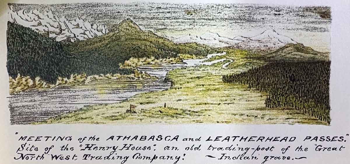
“Meeting of the Athabasca and Leatherhead Passes. Site of the ‘Henry House,’ an old trading-post of the Great North West Trading Company! — Indian grave— Rylatt p. 131
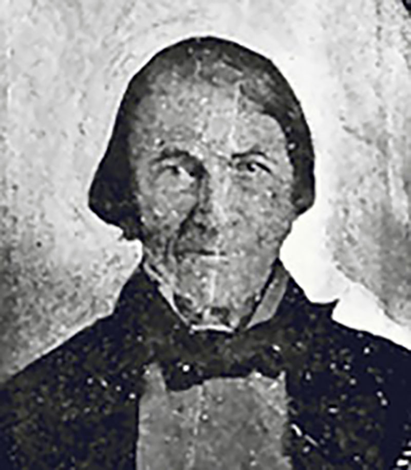
William Henry (1784-1864). From “Travels and Adventures” (Bain, ed., Boston, 1901 Red River Ancestry
On the Palliser map, “Miette or Henry Ho.” is at the confluence of the Miette River and Athabasca River, modern-day Jasper.
This post is denoted “Henry’s House (2)” in Ernest Voorhis [1859–1933], “Historic Forts.”
Alexander Henry Jr. built a Henry House in 1811 on the upper Athabaska river at the confluence of the Miette river, facing Yellowhead pass. It was destroyed after two or three years. [1]
“Henry’s House” or “William Henry’s Old House” was a minor North West Company [1779–1821] trading post on the route to Athabasca Pass. In 1811, while David Thompson [1770–1857] was making the first recorded crossing the pass, William Henry, the eldest son of Alexander Henry [1739–1824], provided support on the eastern side of the mountains [2].
Henry built a post on the Athabasca River near the mouth of the Miette River, where the trails from the Athabasca and Yellowhead passes reached the head of navigation.