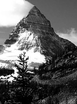
British Columbia. Mount
SE of Yellowhead Lake
52.8306 N 118.4569 W — Map 083D16 — Google — GeoHack
Earliest known reference to this name is 1863 (Milton and Cheadle)
Name officially adopted in 1951
Official in BC – Topo map from Canadian Geographical Names
SE of Yellowhead Lake
52.8306 N 118.4569 W — Map 083D16 — Google — GeoHack
Earliest known reference to this name is 1863 (Milton and Cheadle)
Name officially adopted in 1951
Official in BC – Topo map from Canadian Geographical Names
This mount appears on:
Milton and Cheadle’s map 1865
Wheeler’s map Mount Robson 1912
Boundary Commission Sheet 29 (surveyed in 1917)
Milton and Cheadle’s map 1865
Wheeler’s map Mount Robson 1912
Boundary Commission Sheet 29 (surveyed in 1917)
In 1863, the party of William Wentworth Fitzwilliam Milton [1839–1877] and Dr. Walter Butler Cheadle [1835–1910] was camped on the shore of Buffalo Dung Lake (Yellowhead Lake). Their Iroquois guide assured the travelers that two nearby mountains “should be known from that time forth as Le montaigne de Milord and Montaigne de Docteur. We, however,” wrote Cheadle, “took the liberty of naming them Mount Fitzwilliam and Mount Bingley.” Milton’s title was Viscount Milton of Fitzwilliam. Cheadle described Mount Fitzwilliam as “a fine hill, cone-like and terraced.” The mountain was called Mount Pélée by Arthur Philemon Coleman [1852–1939] in 1907.
References:
- Milton, William Wentworth Fitzwilliam [1839–1877], and Cheadle, Walter Butler [1835–1910]. The North-West Passage by Land. Being the narrative of an expedition from the Atlantic to the Pacific, undertaken with the view of exploring a route across the continent to British Columbia through British territory, by one of the northern passes in the Rocky Mountains. London: Cassell, Petter and Galpin, 1865. Internet Archive [accessed 10 March 2025]
- Coleman, Arthur Philemon [1852–1939]. The Canadian Rockies: New and Old Trails. London: T. Fisher Unwin, 1911. Internet Archive [accessed 3 March 2025]