Monthly Archives: March 2014

Adolphus Lake

Alberta. Lake: Smoky River drainage
Head of Smoky River in Robson Pass
53.1711 N -119.1178 W — Map 083E03 — GoogleGeoHack
Earliest known reference to this name is 1910 (Coleman)
Name officially adopted in 1956
Topo map from Canadian Geographical Names
Adolphus Moberly, an Iroquois halfbreed. Coleman 1908 p. 360.

Adolphus Moberly, an Iroquois halfbreed. Coleman 1908 p. 360.


Lake Robson Pass. J. Norman Collie, 1910

Lake Robson Pass. J. Norman Collie, 1910 The Geographical Journal

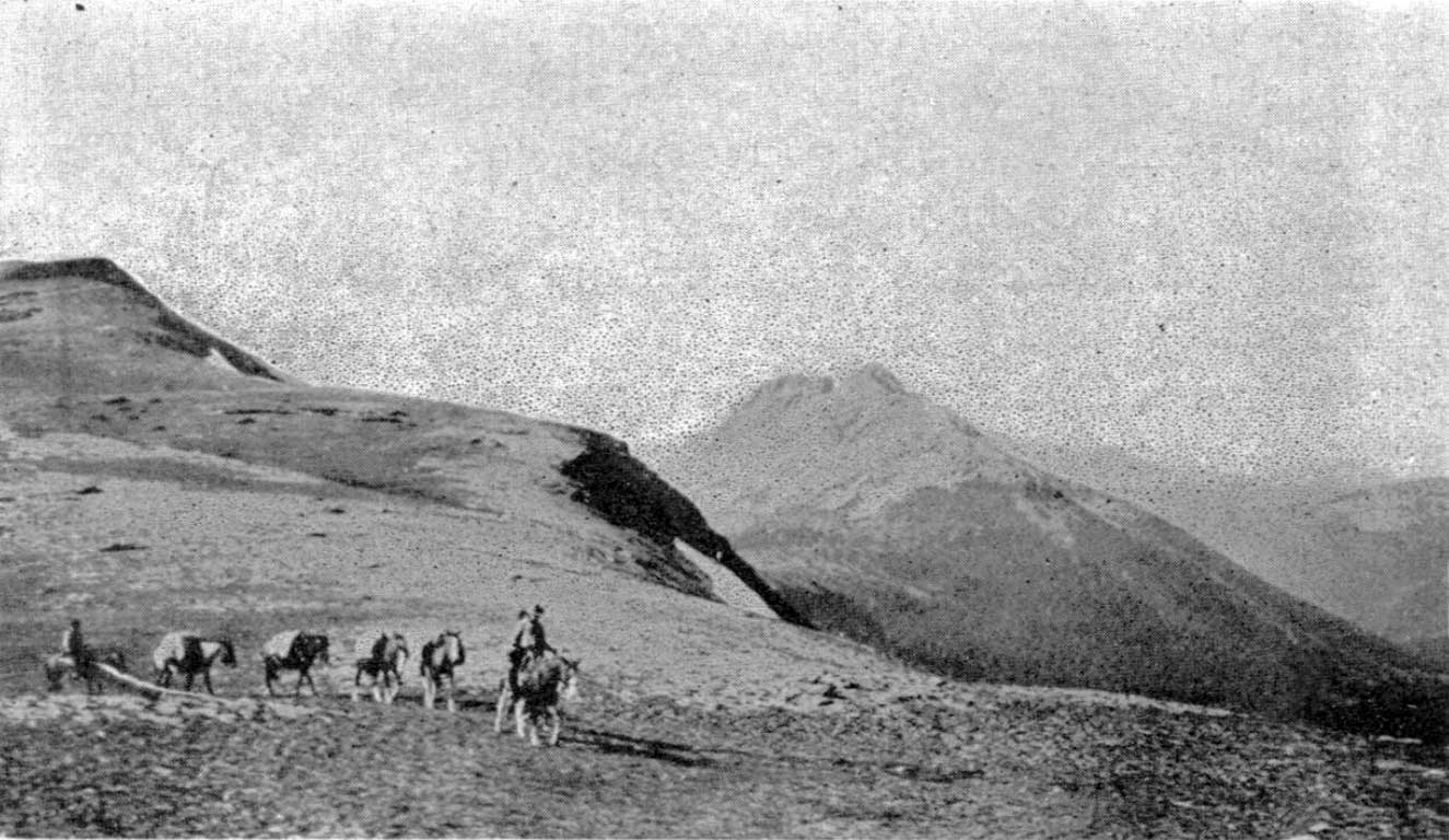
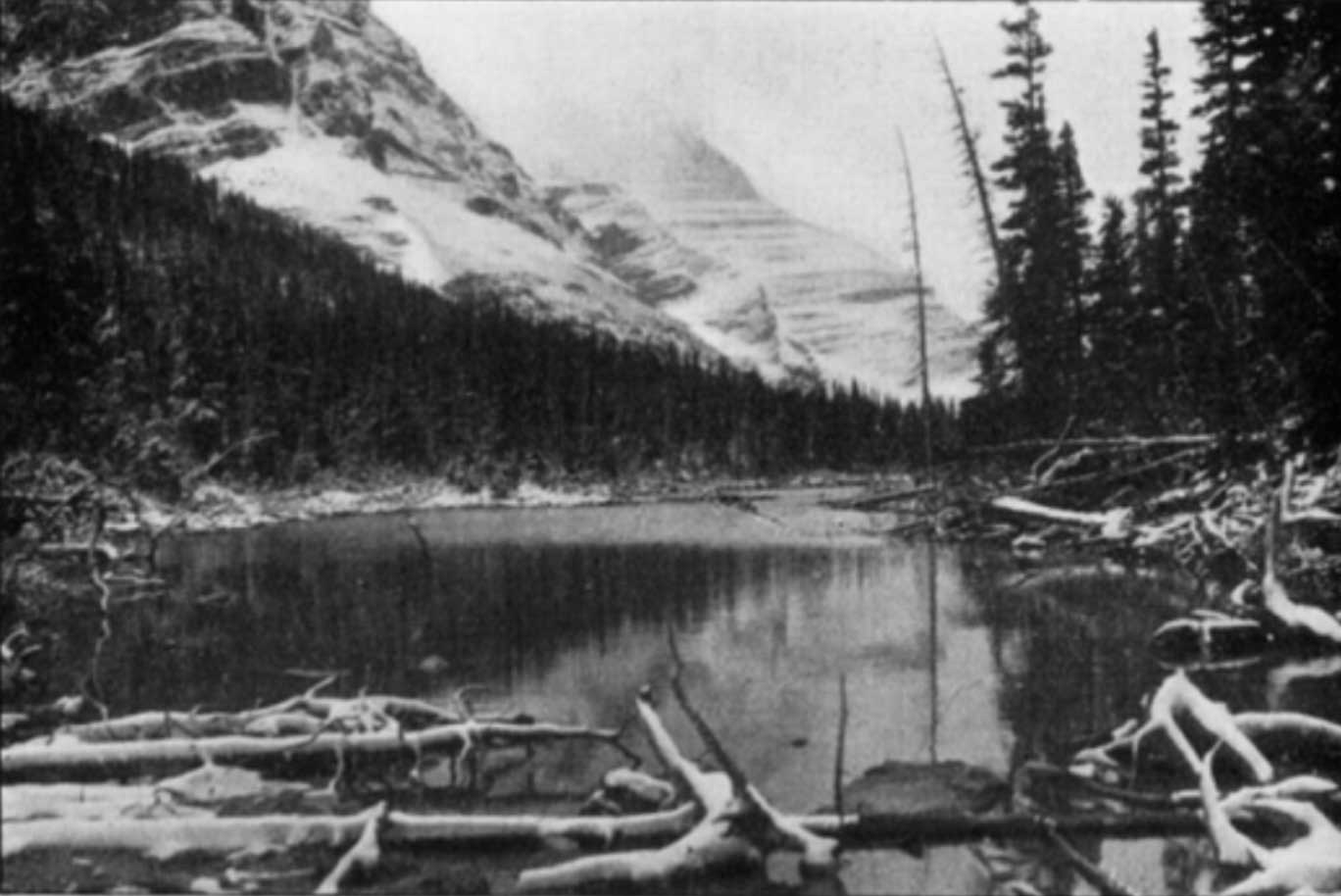
“Nestling in a setting of dark green spruce and scintillating like a royal blue gem is the delightfully picturesque little Lake Adolphus, which forms the source of the Big Smoky River flowing from Robson Pass,” wrote surveyor and explorer Arthur Oliver Wheeler [1860–1945] in 1911.[1] The lake is in Alberta, a few hundred metres from the Alberta-British Columbia Boundary.

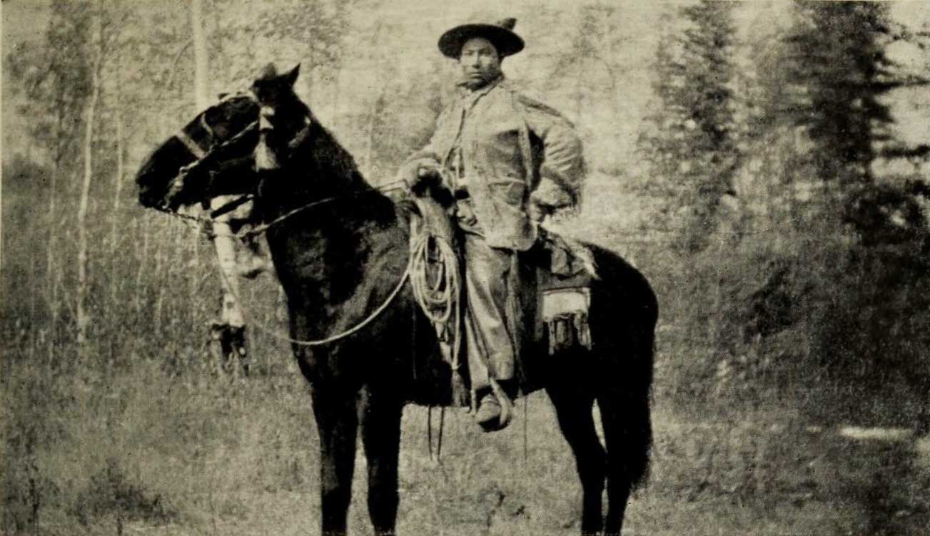
Arthur Philemon Coleman [1852–1939] named the lake after his Métis guide Adolphus Moberly [b. ca. 1887]: “Brawny Adolphus was ignorant but a mighty hunter and a born leader.” [2] Adolphus guided Coleman from Jasper to Robson Pass on the geology professor’s 1908 attempt to climb Mount Robson.

“Adolphus was the most typical and efficient savage I ever encountered,” Coleman wrote, “a striking figure, of powerful physique and tireless muscles, and thoroughly master of everything necessary for the hunter in the mountains. Mounted erect on his horse, with gay clothing and trappings, he was the ideal centaur.” Adolphus led Coleman’s party up the Moose River valley, and left the group after pointing out the way to Robson Pass.

Adolphus’s family was among the six or seven Métis families who were forced to leave the Jasper area after the establishment of Jasper Forest Park in 1907. “The fall of 1909 there was Adam Joachim, Tommy Groat, William, Adolphus, if I remember rightly where were four men came from Jasper House,” recalled James Shand Harvey [1880–1968]. “William and Adolphus Moberly, and there was Tommy Groat, he was just going to get married, no, he was married then, to his wife Clarice (Clarice Moberly, Ewan’s daughter), and Adam Joachim. Old Ewan and John, they both stayed on the place, figured they were too old to work, the younger fellows could build the houses. They put the houses up and some time before New Year they moved in. They stayed there at Rat Lake. And the only one of the bunch that did not go to Grande Cache was Isadore Finley.”

References:

  • 1. Wheeler, Arthur Oliver [1860–1945]. “The Alpine Club of Canada’s expedition to Jasper Park, Yellowhead Pass and Mount Robson region, 1911.” Canadian Alpine Journal, Vol. 4 (1912):9-80. Alpine Club of Canada [accessed 2 April 2025]
  • 2. Coleman, Arthur Philemon [1852–1939]. The Canadian Rockies: New and Old Trails. London: T. Fisher Unwin, 1911. Internet Archive [accessed 3 March 2025]

Beaverpelt Lake

British Columbia. Previously official: Columbia River drainage
W of Canoe River near Glacier Creek
52.7125 N 119.075 W — Map 83D/11 — GoogleGeoHack
Name officially adopted in 1954
Not currently an official name

The name was adopted in 1954 as a long-established local name, and rescinded in 1974 due to flooding of McNaughton (now Kinbasket) Lake

References:

Also see:

The Beaver

British Columbia. Mountain
N of Fraser River near junction with Holmes River
53.275 N 119.9611 W — Map 83E/5 — GoogleGeoHack
Earliest known reference to this name is 1912
Name officially adopted in 1994
Official in BCCanada

A mountain prominent in the McBride skyline. Some say the rock formation at the summit resembles a beaver. This rock formation may be the reason that the adjacent Holmes River was first called “Beaver River.”

Designated as “Mammoth Mountain” on the Preliminary map of the Canadian Rocky Mountains between Jarvis Pass and Yellowhead Pass (Bull. Amer. Geog. Soc. Vol. XLVII, No. 7, 1915), showing the route followed by Mary Lenore Jobe Akeley [1878–1966] in August 1914, with guide Donald “Curly” Phillips [1884–1938].

References:

  • Washburn, Stanley [1878–1950]. Trails, Trappers and Tenderfeet in the New Empire of Western Canada. New York and London: Henry Holt, Andrew Melrose, 1912. Hathi Trust
  • Jobe Akeley, Mary Lenore [1878–1966]. “Mt. Kitchi: A New Peak in the Canadian Rockies.” Bulletin of the American Geographical Society, Volume 47, No. 7 (1915):481-497, Map follows p. 496. JSTOR
  • British Columbia Geographical Names. The Beaver

Barnett Road

British Columbia. Road
Forks N off Croydon Road North Road W of Croydon
53.0832 N 119.7496 W GoogleGeoHack
Roads are not in the official geographical names databases

Frederick William (1886–1979) and Jessie Sterling (Gray) (1888–1975) Barnett were natives of Glasgow, Scotland, who lived in Croydon from 1922 until 1973. Fred came to Canada in 1905, moving from Calgary to Manitoba to Saskatchewan. When her mother died in 1907, Jessie also immigrated to Canada, settling in Montréal. Fred and Jessie, who had known each other since childhood, were married in 1910. Their daughters Nora and Louise were born in Saskatchewan. In the early 1920s the Barnetts read an article in the Winnipeg Free Press about homesteads in the Croydon-Dunster area. In 1922, after 12 years of fighting hailstorms and grasshoppers on the prairies, they moved to Croydon and started clearing land. Fred shipped strawberries to Jasper and raised mink and fox until the Depression put an end to these small businesses. They sold the homestead in 1939 and Jessie started a small store, also continuing as postmistress of Croydon, a position she had started in 1926. Fred worked as carpenter on the construction of the Alaska Highway. Jessie retired from the post office in 1968, at the age of 81, and the office was closed. In 1973, they sold the one-and-a-half acre property and moved to McBride.

References:

  • Wheeler, Marilyn [1932–2016]. The Robson Valley Story. McBride, B.C.: Robson Valley Story Group, 1979

Bailey Road

British Columbia. Road
Forks E off Whiskey Fill Road S of Valemount
52.8056 N 119.225 W GoogleGeoHack
Roads are not in the official geographical names databases

Possibly named for Ross Bailey [d. 1962], an employee ofCanadian National Railway for 15 years, working at various points between Jasper and Vancouver. At the time of his death he lived in Red Pass Junction (1).

References:

  • 1. Valley Echo. Weekly newspaper published in McBride. 1957–1962

Mount Bagg

British Columbia. Mount
S of Morkill River, between Hellroaring Creek and Cushing Creek
53.6333 N 120.45 W — Map 93H/9 — GoogleGeoHack
Earliest known reference to this name is 1915
Name officially adopted in 1965
Official in BCCanada

“Mt. Bagg” appears on the “Preliminary Map of the Canadian Rocky Mountains between Jarvis Pass and Yellowhead Pass” showing the route followed by Mary Lenore Jobe Akeley [1878–1966] in August 1914 with guide Donald “Curly” Phillips [1884–1938].

The name was adopted in 1965 as labelled on BC Lands’ map 1G, 1916. Origin/significance not recorded.

References:

  • Jobe Akeley, Mary Lenore [1878–1966]. “Mt. Kitchi: A New Peak in the Canadian Rockies.” Bulletin of the American Geographical Society, Volume 47, No. 7 (1915):481-497, Map follows p. 496. JSTOR
  • British Columbia Geographical Names. Bagg, Mount

Avalanche Pass

Alberta-BC boundary. Pass
Fraser River and Smoky River drainages
Between Morkill River and Pauline Creek
53.6161 N 119.9108 W — Map 083E12 — GoogleGeoHack
Earliest known reference to this name is 1914 (Jobe)
Name officially adopted in 1925
Official in BCCanada
Alpland above Avalanche Pass, 1914.

Alpland above Avalanche Pass, 1914.
Bulletin of the American Geographical Society

The pass was named by members of the 1914 expedition to Mount Sir Alexander (then know as Mount Kitchi) led by Mary Lenore Jobe Akeley [1878–1966] and Donald “Curly” Phillips [1884–1938].

From Jones Pass we cut our way through dense woods down a steep declivity to broad open muskeg on the West Branch of the Jack Pine. After traveling about six miles through this meadow we came to a low pass, 5,300 feet, filled with beaver dams and houses. We named this pass Beaver Dam Pass. It separates Fraser and Peace waters. Another broad stretch of muskeg and we reached another pass, on which a huge avalanche of trees and rocks had descended. At Avalanche Pass our aneroid registered 5,300 feet. Our further progress was here checked by dense woods filled with an undergrowth of devils’ club and rhododendron of the British Columbia variety.

— Jobe 1914

“The reason for the name is unknown,” wrote boundary surveyor Arthur Oliver Wheeler [1860–1945] in 1924, “but may be due to a snow-slide that happened close by the summit of the pass many years ago and has left some rotting debris of the timber it swept down at the time. It is not a spectacular slide and but slight indication of it is left to tell the tale. There are no other indications of avalanches in the immediate vicinity.”

References:

  • Jobe Akeley, Mary Lenore [1878–1966]. “The expedition to ‘Mt. Kitchi:’ A new peak in the Canadian Rockies.” Canadian Alpine Journal, Vol. 6 (1914–1915):135-143
  • Jobe Akeley, Mary Lenore [1878–1966]. “Mt. Kitchi: A New Peak in the Canadian Rockies.” Bulletin of the American Geographical Society, Volume 47, No. 7 (1915):481-497. JSTOR
  • Cautley, Richard William [1873–1953], and Wheeler, Arthur Oliver [1860–1945]. Report of the Commission appointed to delimit the boundary between the Provinces of Alberta and British Columbia. Part II. 1917 to 1921. From Kicking Horse Pass to Yellowhead Pass.. Ottawa: Office of the Surveyor General, 1924. Whyte Museum
  • Cautley, Richard William [1873–1953], and Wheeler, Arthur Oliver [1860–1945]. Report of the Commission Appointed to Delimit the Boundary between the Provinces of Alberta and British Columbia. Parts IIIA & IIIB, 1918 to 1924. From Yellowhead Pass Northerly. Ottawa: Office of the Surveyor General, 1925. Whyte Museum
  • British Columbia Geographical Names. Avalanche Pass

Alpland station

British Columbia. Former railway point
Between Lucerne (GTP railway point) and Grant Brook (GTP railway point)
53.0278 N 119.1778 W — Map 83E/3 — GoogleGeoHack
Earliest known reference to this name is 1912 (Wheeler map)
Name officially adopted in 1951
Not currently an official name
10 miles west of the Yellowhead Pass on the Canadian National Railway
Grand Trunk Pacific Railway station built in 1913. Formerly Mt. Robson

Adopted in 1951 on Jasper Park (North) sheet (file J.1.34), as identified on Canadian National Railway timetables; name cancelled in 1989.

Grand Trunk Pacific Railway station Mount Robson (railway point) had originally been located here, but the station by that name was relocated southward and the Canadian National Railway renamed the facility at this location “Alpland” in 1924.

References:

  • British Columbia Geographical Names. Alpland
Also see:

Alpland Ridge

British Columbia. Ridge
NE of Moose Lake in Mount Robson Park
52.9831 N 119.0953 W — Map 083D14 — GoogleGeoHack
Name officially adopted in 1980
Official in BCCanada

Adopted 31 December 1973 in the 1973 Cumulative Supplement to the 1966 BC Gazetteer, as recommended March 1972 by BC Parks “…the ridge lies above the railway station of Alpland.”

References:

Also see: