Author Archives: Swany

James McEvoy’s 1900 map showing Yellowhead Pass route from Edmonton to Tête-Jaune Cache

Map Showing Yellowhead Pass Route From Edmonton To Tête-Jaune Cache. James McEvoy, 1900.

Map Showing Yellowhead Pass Route From Edmonton To Tête-Jaune Cache. James McEvoy, 1900.
Natural Resources Canada


Map Showing Yellowhead Pass Route From Edmonton To Tête-Jaune Cache. 
James McEvoy, 1900. (Detail of Yellowhead Pass to Tête Jaune Cache)

Map Showing Yellowhead Pass Route From Edmonton To Tête-Jaune Cache.
James McEvoy, 1900. (Detail of Yellowhead Pass to Tête Jaune Cache)
Natural Resources Canada

James McEvoy [1862–1935] — Map showing the Yellowhead Pass route from Edmonton to Tête-Jaune Cache, 1900.

In 1898 McEvoy surveyed the Athabasca River valley for about 240 kilometres east of the Yellowhead Pass, and down the Fraser River on the west side of the pass for another 120 kilometres.

The splendid report of James McEvoy, published by the Geological Survey of Canada in 1900, dealing with the geology and natural history resources of the country traversed by the Yellowhead Pass route from Edmonton to Tête-Jaune Cache, contains the most comprehensive and reliable geographical information that has yet been published, and also contains the only geographical map published of that route on a sufficiently large scale to be of value.

Arthur Oliver Wheeler [1860–1945], 1912
References:

  • McEvoy, James [1862–1935]. Report on the geology and natural resources of the country traversed by the Yellowhead Pass route from Edmonton to Tête Jaune Cache comprising portions of Alberta and British Columbia. Ottawa: Geological Survey of Canada, 1900. Natural Resources Canada
  • McEvoy, James [1862–1935]. “Map Showing Yellowhead Pass Route From Edmonton To Tête-Jaune Cache.” (1900). Natural Resources Canada
  • Wheeler, Arthur Oliver [1860–1945]. “The Alpine Club of Canada’s expedition to Jasper Park, Yellowhead Pass and Mount Robson region, 1911.” Canadian Alpine Journal, Vol. 4 (1912):9-80

Coleman’s map Mount Robson 1911

Map of Mount Robson based on expeditions in 1907 and 1908. By A. P. Coleman.

Map of Mount Robson based on expeditions in 1907 and 1908. By A. P. Coleman. Canadian Alpine Journal, 1910


Mt. Robson Region map by A. P. Coleman, 1911

Mt. Robson Region map by A. P. Coleman, 1911 The Canadian Rockies : new and old trails, p. 264 [accessed 15 February 2025]

Canadian geologist Arthur Philemon Coleman [1852–1939] made extensive early explorations of the Canadian Rockies, including the first attempts to climb Mount Robson in 1907 and 1908.

This map includes:
Adolphus Lake [as “L. Adolph”]
Berg Lake
Grand Forks River
The Helmet [as “Helmet”]
Kinney Lake [as “L. Kinney”]
Lynx Mountain [also “Lynx Range”]
Moose River
Moose Lake
Ptarmigan Mountain
Rearguard Mountain [as “Rear Guard”]
Resplendent Mountain
Mount Robson
Smoky River
Whitehorn Mountain [as “White Horn Mt.”]
References:

  • Coleman, Arthur Philemon [1852–1939]. “Expedition to Mt. Robson.” Canadian Alpine Journal, Vol. 1, No. 2 (1908):100-103. Alpine Club of Canada [accessed 2 April 2025]
  • Coleman, Arthur Philemon [1852–1939]. “Geology and glacial features of Mt. Robson.” Canadian Alpine Journal, Vol. 2, No. 2 (1910):73-78. Alpine Club of Canada [accessed 2 April 2025]
  • Coleman, Arthur Philemon [1852–1939]. “Mount Robson, the Highest Point in the Canadian Rockies.” The Geographical Journal (London), Vol. 36, No. 1 (July 1910). JSTOR [accessed 3 March 2025]
  • Coleman, Arthur Philemon [1852–1939]. The Canadian Rockies: New and Old Trails. London: T. Fisher Unwin, 1911. Internet Archive [accessed 3 March 2025]
Also see:

Joseph Trutch’s 1871 map of British Columbia

Trutch, Joseph William. Map of British Columbia to the 56th Parallel North Latitude, 1871

Trutch, Joseph William. Map of British Columbia to the 56th Parallel North Latitude, 1871
University of Victoria


Trutch, Joseph William. Map of British Columbia to the 56th Parallel North Latitude, 1871 (detail)

Trutch, Joseph William. Map of British Columbia to the 56th Parallel North Latitude, 1871 (detail)
University of Victoria

References:

  • Trutch, Joseph William [1826–1904]. Map of British Columbia to the 56th Parallel North Latitude. Victoria, B.C.: Lands and Works Office, 1871. University of Victoria
  • Wikipedia. Joseph Trutch

Aaron Arrowsmith’s map North America 1795

British possessions in America. Aaron Arrowsmith, 1795 Library and Archives Canada

British possessions in America. Aaron Arrowsmith, 1795 Library and Archives Canada Historical Atlas of Canada


Arrowsmith, detail

Arrowsmith, detail Historical Atlas of Canada

Aaron Arrowsmith [1750–1823] incorporated information from Hudson’s Bay Company manuscript maps and journals, the journals of Alexander Mackenzie [1764–1820] (which weren’t published until 1803), and the survey of the northwest coast by George Vancouver [1757–1798].

The general shape of northwestern North America south of the Arctic was now established, although innumerable details remained to be filled in, including the routes of Fraser River and Columbia River.

This map includes:
Lake Athabasca
Columbia River [as “Tacoutche Tesse or Columbia R.”]
Peace River
Rocky Mountains
Tacoutche Tesse
References:

Cook’s 1784 map

Map of the world in Cook’s “Third Voyage,” 1784. By Henry Roberts, Lieutenant in His Majesty’s Navy

Map of the world in Cook’s “Third Voyage,” 1784. By Henry Roberts, Lieutenant in His Majesty’s Navy Princeton University Library


Detail of map of the world in Cook’s “Third Voyage,” 1784. By Henry Roberts, Lieutenant in His Majesty’s Navy

Detail of map of the world in Cook’s “Third Voyage,” 1784. By Henry Roberts, Lieutenant in His Majesty’s Navy UBC Library Digital Collections

According to the Champlain Society edition of Samuel Hearne’s journeys, this map was the first to show the route of Captain James Cook [1728–1779].
This map includes:
Lake Athabasca [as Arathapescow Lake]
References:

  • Roberts, Henry. London: A General Chart exhibiting the Discoveries made by Capn. James Cook in this and his two preceeding Voyages; with the Tracks of the Ships under his Command (1784). Princeton Library
  • Hearne, Samuel [1745–1792]. A journey from Prince of Wales’s Fort in Hudson’s Bay to the Northern Ocean, in the years 1769, 1770, 1771, and 1772. Tyrrell, Joseph Burr, 1858-1957. Totonto: Champlain Society, 1911. Internet Archive
  • Cook, James [1728–1779]. A Voyage to the Pacific Ocean. Undertaken, by the Command of His Majesty, for Making Discoveries in the Northern Hemisphere, to Determine the Position and Extent of the West Side of North America; Its Distance from Asia; and the Practicability of a Northern Passage to Europe. Performed under the Direction of Captains Cook, Clerke, and Gore, in His Majesty’s Ships the Resolution and Discovery, in the Years 1776, 1777, 1778, 1779, and 1780. Vol III. London: G. Nicol, & T. Cadell, 1796. University of British Columbia Library

Mackenzie’s map North America 1803

Map of Mackenzie’s 1789 and 1873 expeditions

Map of Mackenzie’s 1789 and 1873 expeditions Internet Archive


Map of Mackenzie’s 1789 and 1793 expeditions (detail)

Map of Mackenzie’s 1789 and 1793 expeditions (detail) Internet Archive


A map of Mackenzie’s track from Fort Chipewan to the Pacific Ocean in 1793

A map of Mackenzie’s track from Fort Chipewan to the Pacific Ocean in 1793 Internet Archive


A map of Mackenzie’s track from Fort Chipewan to the Pacific Ocean in 1793 (detail)

A map of Mackenzie’s track from Fort Chipewan to the Pacific Ocean in 1793 (detail) Internet Archive

In 1793 Alexander Mackenzie [1764–1820] lead the first expedition of European descendants to cross the American continent north of Mexico.

He crossed the Continental Divide through a pass that remains unnamed, although a park has been created in its surroundings. The only name honouring Mackenzie in the area is Mount Sir Alexander, a mountain he never saw.

On the map of Mackenzie’s route across the Divide, the only original name that survives is Bad River, which appears next to his note, “Canoe Wreck’d.”

“Bad River” was superseded with the name “James Creek” by the Geographic Board of Canada in 1924; however, in 1976 to accommodate local usage, which dates to the earliest days of exploration in the northern Rocky Mountains, the name “Bad River (James Creek)” was established.

References:

  • Mackenzie, Alexander [1764–1820]. Voyages from Montreal on the River St. Lawrence through the Continent of North America to the Frozen and Pacific Oceans in the Years 1789 and 1793 with a Preliminary Account of the Rise, Progress, and Present State of the Fur Trade of That Country. London: T. Cadell, Jun., and W. Davies, 1803. Internet Archive
  • Mackenzie, Alexander [1764–1820]. A map of America, between latitudes 40 and 70 North, and longitudes 45 and 180 West, exhibiting Mackenzie’s Track from Montreal to Fort Chipewyan and from thence to the North Sea in 1789 & to the West Pacific Ocean in 1793. London: T. Cadell, Jun., and W. Davies, 1803, facing page 1. Internet Archive

South Fork Fraser River

British Columbia. Former name: Fraser River drainage
Downstream from headwaters to the confluence with McGregor River
Earliest known reference to this name is 1871 (Trutch map)
Not currently an official name.
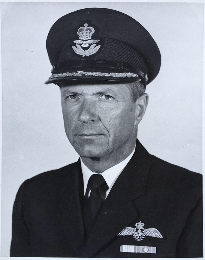
Considering the confluence of McGregor River and Fraser River to be a fork, then the South Fork of the Fraser River runs up from the fork though Tête Jaune Cache to the headwaters at the Continental Divide in Mount Robson Park.

This nomenclature was formally adopted by the Geographic Board of Canada in 1910, as long-identified on maps and in journals. But in 1915 the Board renamed North Fork of the Fraser River to McGregor River, and Fraser River proper became the main source of the channel, the old South Fork of the Fraser River.(1)

I left Vancouver on May 20th. 1912, with a party of twelve men to survey land within the reserve on the South Fork of the Fraser River, about fifty miles below Tete Jaune Cache. There are three different routes to get into this country, probably the most expeditious one being via Edmonton-the way we went. Taking from Edmonton, by special permission of the Railway Commission, we travelled over the Grand Trunk Pacific as far as the end of steel. which at that time was Resplendent, twenty-nine miles west of the British Columbia-Alberta boundary. Owing to the fact that the Grand Trunk has not been opened for traffic farther west than Hinton, 185 miles west of Edmonton, it was necessary to get this special permission before we were allowed to travel the remaining ninety-eight miles to the end of steel. (2)

References:

  • 1. British Columbia Geographical Names. Fraser River
  • 2. Augustine, Alpheus Price [d. 1928]. “Report on Surveys on the South Fork of Fraser River.” Report of the Minister of Lands for the Province of British Columbia for the year ending 31st December 1912, (1913):240-242. Google Books

Columbia River

British Columbia. River: Columbia River drainage
Headwaters are Columbia Lake at Canal Flats
48.9997 N 117.6322 W — Map 82F/4 — GoogleGeoHack
Earliest known reference to this name is 1792 (Gray)
Name officially adopted in 1910
Official in BCCanada
Elevation: 3747 m

Adopted in the 9th Report of the Geographic Board of Canada, 1910, as named on maps and charts since 1795.

Called “Oregon River” by Jonathan Carver, 1766. Called “Rio de San Roque” by Bruno Heceta, who discovered the river’s mouth in 1775, and so-labelled on Spanish charts.

Named “Columbia River” in 1792, by Captain Robert Gray of Boston, after his ship Columbia, which entered the mouth of the river in May of that year. The name of Gray’s vessel honours Christopher Columbus, who reached the Americas in 1492.

“Columbia River / Fleuve Columbia” is among the 75 “Pan-Canadian names,” large and well-known Canadian features and areas designated in Treasury Board Circular 1983-58 to require presentation in both official languages of Canada on federal maps. In French, a fleuve is a river that flows into an ocean or sea.

References:

  • Arrowsmith, John [1790–1873]. Provinces of British Columbia and Vancouver Island; with portions of the United States and Hudson’s Bay Territories. 1859. UVic
  • British Columbia Geographical Names. Columbia River
  • Wikipedia. Columbia River

Athabasca River

Alberta. River: Athabasca River drainage
Flows 1290 kilometres from Columbia Icefield to Lake Athabasca
58.6667 N 110.8333 W — Map 74L10 — GoogleGeoHack
Earliest known reference to this name is 1800 (David Thompson)
Name officially adopted in 1948
Topo map from Canadian Geographical Names

“Athabasca” is from the Cree language and is said to mean “an area of grass or reeds.” The name likely refers to the muddy delta of the river where it flows into Lake Athabasca.

In 1790, the name of the river was recorded as “Great Arabuska.” In 1801 it was labelled “Athapasco.” The Arrowsmith map of 1802 shows a slight variation as “Arthapescow.” In the late eighteenth century, the Dunne-za people who lived along its banks called it the “Elk River,” and it appears as “Elk River” on the 1801 map by Alexander Mackenzie [1764–1820] .

David Thompson [1770–1857] and Peter Fidler [1769–1822], who explored the middle section of the river in 1799–1800, both referred to it in their journals as the “Athabasca.”

In 1820, George Simpson [1792–1860], the governor of the Hudson’s Bay Company, referred to it as the “Athabasca or Elk River.” Today, local residents also refer to the feature as “Big River,” the Cree version of which was in use in 1880 when George Mercer Dawson labelled it as “Athabasca River or Mus-ta-hi-sî-pî.”

“Athabasca River / Rivière Athabasca” is among the 75 “Pan-Canadian names,” large and well-known Canadian features and areas designated in Treasury Board Circular 1983-58 to require presentation in both official languages of Canada on federal maps.

References:

  • Thompson, David [1770–1857]. David Thompson’s Narrative of his explorations in western America, 1784-1812. Joseph Burr Tyrrell, editor. Toronto: Champlain Society, 1916. University of British Columbia
  • Simpson, George [1792–1860], and Merk, Frederick [1887–1977], editor. Fur trade and empire. George Simpson’s journal entitled Remarks connected with fur trade in consequence of a voyage from York Factory to Fort George and back to York Factory 1824-25. Cambridge, Mass.: Harvard University Press, 1931. University of British Columbia Library
  • Aubrey, Merrily K. Place Names of Alberta. Volume IV: Northern Alberta. University of Calgary Press, 1996
  • Aubrey, Merrily K. Concise Place Names of Alberta. University of Calgary Press, 2006
  • Wikipedia. Athabasca River

Athabasca, Lake

Alberta. Lake: Athabasca River drainage
NW corner of Saskatchewan and NE corner of Alberta between 58° and 60° N.
59.0833 N 110.1667 W — Map 74 M/1 — GoogleGeoHack
Earliest known reference to this name is 1784 (Cook)
Name officially adopted in 1983
Official in Canada
Detail of map of the world in Cook’s “Third Voyage,” 1784. By Henry Roberts, Lieutenant in His Majesty’s Navy

Detail of map of the world in Cook’s “Third Voyage,” 1784. By Henry Roberts, Lieutenant in His Majesty’s Navy
UBC Library Digital Collections

The lake appears as “Arathapescow Lake” on the chart accompanying James Cook’s A Voyage to the Pacific Ocean, published in 1784. The chart displays the voyages of Captain Cook; the details about the interior of North America came from fur trade sources.

Alexander Mackenzie [1764–1820], starting his voyage from Fort Chepewyan on Lake Athabasca to the Pacific Ocean in October 1792, wrote:

We entered the Peace River at seven in the morning of the 12th, taking a Westerly course. It is evident, that all the land between it and the Lake of the Hills, as far as the Elk River, is formed by the quantity of earth and mud, which is carried down by the streams of those two great rivers. In this space there are several lakes. The lake, Clear Water, which is the deepest, Lake Vassieu, and the Athabasca Lake, which is the largest of the three, and whose denomination in the Knistineaux language, implies, a flat low, swampy country, subject to inundations.

On the Mackenzie’s 1803 map, the lake appears as “Lake of the Hills.” On Aaron Arrowsmith’s 1795 map the lake is called “Athapescow Lake.”

The word Athabaskan is an anglicized version of a Cree language name for Lake Athabasca (Cree: Āðapāskāw “[where] there are reeds one after another”). Cree is one of the Algonquian languages and therefore not itself an Athabaskan language.

In the 18th century the territory around the lake was occupied by indigenous Dane-zaa (historically referred to as the Beaver tribe by Europeans) and Chipewyan people. Both are of the Athabaskan language family.

In Albert Lacombe’s Dictionnaire de la langue des Cris (1874), the lake and river are called “Athabaskaw” in the accompanying map, but there is not an entry for that specific word. Lacombe does cite as an unspecified place name “Ayabaskaw” or “Arabaskaw,” meaning “il y a des joncs ou du foin ça et là” [There are rushes and hay here and there] (p. 705).

In 1790, it was referred to as “Lake of the Hills,” and the river, the Great Arabuska. Lake of the Hills may have been a more genteel translation of the name for the lake at the time. Peter Fidler recorded the Cree name as Too-toos Sack-a-ha-gan, and the Chipewyan name as Thew Too-ak. The literal translation of the Cree name is “breast” lake, referring to the north-west shore, which according to Philip Turnor in 1791, came “from their appearing high and rounded at a distance.”

However, the most commonly accepted version of the origin of the name is from the Cree, where it is said to mean “where there are reeds,” referring to the muddy delta of the river where it falls into Lake Athabasca. Of this portion of it, Turner wrote “low swampy ground on the South side with a few willows growing upon it, from which the Lake in general takes its name Athapison in the Southern [Cree] tongue [which] signifies open country such as lakes with willows and grass growing about them.” In 1820, George Simpson of the Hudson’s Bay Company referred to it as the “Athabasca or Elk River.”

“Athabasca, Lake / Lac Athabasca” is among the 75 “Pan-Canadian names,” large and well-known Canadian features and areas designated in Treasury Board Circular 1983-58 to require presentation in both official languages of Canada on federal maps.

References:

  • Roberts, Henry. London: A General Chart exhibiting the Discoveries made by Capn. James Cook in this and his two preceeding Voyages; with the Tracks of the Ships under his Command (1784). Princeton Library
  • Hearne, Samuel, and Turnor, Phillip. Journals of Samuel Hearne and Philip Turnor between the years 1774 and 1792. Champlain Society, 1934. Internet Archive
  • Arrowsmith, Aaron [1750–1823]. A Map Exhibiting All the New Discoveries in the Interior Parts of North America. Engraved by Lowry. Cadell and Davies, 1795. Historical Atlas of Canada
  • Mackenzie, Alexander [1764–1820]. A map of America, between latitudes 40 and 70 North, and longitudes 45 and 180 West, exhibiting Mackenzie’s Track from Montreal to Fort Chipewyan and from thence to the North Sea in 1789 & to the West Pacific Ocean in 1793. London: T. Cadell, Jun., and W. Davies, 1803. Internet Archive
  • Mackenzie, Alexander [1764–1820]. Voyages from Montreal on the River St. Lawrence through the Continent of North America to the Frozen and Pacific Oceans in the years 1789 and 1793. London: T. Cadell, Jun., and W. Davies, 1803. Internet Archive
  • Simpson, George [1792–1860]. Fur trade and empire. George Simpson’s journal entitled Remarks connected with fur trade in consequence of a voyage from York Factory to Fort George and back to York Factory 1824-25. Frederick Merk, editor. Cambridge, Mass.: Harvard University Press, 1931. University of British Columbia Library
  • Lacombe, Albert [1827–1916]. Dictionnaire de la langue des Cris. Montréal: C. O. Beauchemin & Valois, 1874. Internet Archive
  • Aubrey, Merrily K. Place Names of Alberta. Volume IV: Northern Alberta. University of Calgary Press, 1996
  • Aubrey, Merrily K. Concise Place Names of Alberta. University of Calgary Press, 2006
  • Wikipedia. Lake Athabasca