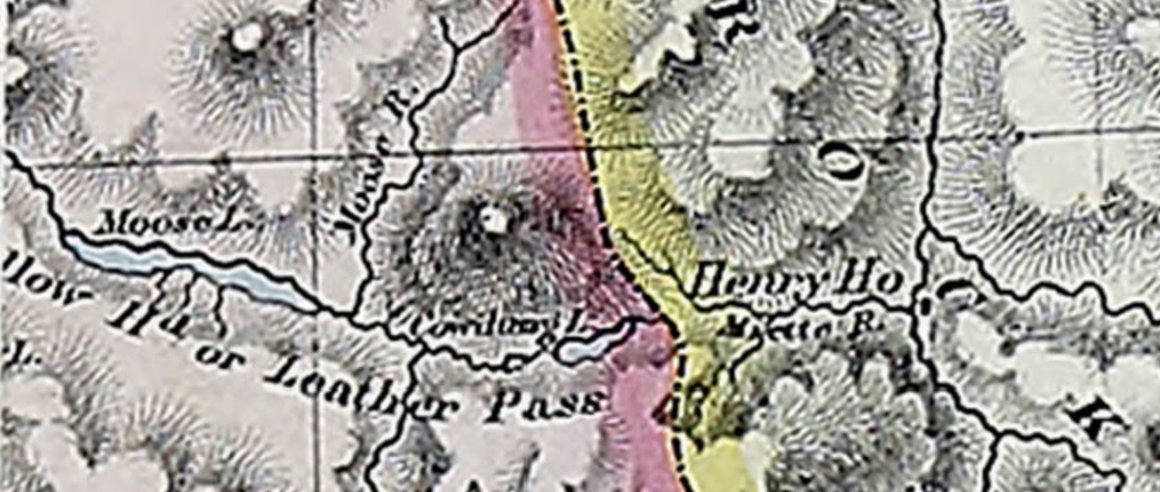
Athabasca Pass
52.3833 N 118.1889 W Google — GeoHack
Earliest known reference to this name is 2001
Official in Canada
Topographical Map Showing Mount Robson and Mountains of the Continental Divide North of Yellowhead Pass. Arthur O. Wheeler, 1912 Victoria Library, University of Toronto
Detail showing stations on the Grand Trunk Pacific Railway. Victoria Library, University of Toronto
Topographical Map Showing Mount Robson and Mountains of the Continental Divide North of Yellowhead Pass
To accompany the Reports of the Alpine Club of Canada’s Expedition, 1911
From Photographic Surveys by Arthur Oliver Wheeler [1860–1945], A.C.C., Director
Annual report of the Topographical Surveys Branch, 1911-1912
With an inset showing a detail of the Geological Survey of Canada’s 1900 map of the Yellowhead Pass Route by James McEvoy [1862–1935] .
Adolphus Lake
Albreda (GTP railway point)
Alpland
Arctomys Valley
Berg Lake
Calumet Creek
Coleman Glacier
The Colonel
Colonel Creek
Emperor Falls
Extinguisher Tower [as “Extinguisher”]
Mount Fitzwilliam
Gendarme Mountain
Grant Brook
Grant Brook (GTP railway point)
Grand Trunk Pacific Railway
Mount Kain
Kinney Lake
Lazuli Lake
Little Grizzly
Mount Longstaff
Lynx Mountain
Miette River
Mount Robson (railway point)
Moose Pass
Moose River
Mount Mowat
Mumm Peak
Mural Glacier
Ptarmigan Mountain
Rainbow (GTP railway point)
Rainbow Canyon
Rainbow Canyon and Falls (Moose River)
Rainbow Range
Razor Peak
Rearguard Mountain
Red Pass Junction
Red Pass
Reef Icefield
Resplendent (GTP railway point)
Resplendent Valley
Mount Robson
Robson Glacier
Selwyn Range
Smoky River
Snowbird Pass
Stoney River [as Stony River]
Swiftcurrent Creek
Terrace Glacier
Terrace Creek
The Helmet
The Dome
Valley of a Thousand Falls
Mount Toot-toot
Trio Mountain [as Trios Pk.]
Upright Mountain
Whitehorn Mountain
Wolverine Creek
Yellowhead Mountain
Yellowhead Lake
Yellowhead (railway point)
Trutch, Joseph William. Map of British Columbia to the 56th Parallel North Latitude, 1871
University of Victoria
Trutch, Joseph William. Map of British Columbia to the 56th Parallel North Latitude, 1871 (detail)
University of Victoria
British possessions in America. Aaron Arrowsmith, 1795 Library and Archives Canada Historical Atlas of Canada
Arrowsmith, detail Historical Atlas of Canada
The general shape of northwestern North America south of the Arctic was now established, although innumerable details remained to be filled in, including the routes of Fraser River and Columbia River.
Considering the confluence of McGregor River and Fraser River to be a fork, then the South Fork of the Fraser River runs up from the fork though Tête Jaune Cache to the headwaters at the Continental Divide in Mount Robson Park.
This nomenclature was formally adopted by the Geographic Board of Canada in 1910, as long-identified on maps and in journals. But in 1915 the Board renamed North Fork of the Fraser River to McGregor River, and Fraser River proper became the main source of the channel, the old South Fork of the Fraser River.(1)
I left Vancouver on May 20th. 1912, with a party of twelve men to survey land within the reserve on the South Fork of the Fraser River, about fifty miles below Tete Jaune Cache. There are three different routes to get into this country, probably the most expeditious one being via Edmonton-the way we went. Taking from Edmonton, by special permission of the Railway Commission, we travelled over the Grand Trunk Pacific as far as the end of steel. which at that time was Resplendent, twenty-nine miles west of the British Columbia-Alberta boundary. Owing to the fact that the Grand Trunk has not been opened for traffic farther west than Hinton, 185 miles west of Edmonton, it was necessary to get this special permission before we were allowed to travel the remaining ninety-eight miles to the end of steel. (2)
Adopted in the 9th Report of the Geographic Board of Canada, 1910, as named on maps and charts since 1795.
Called “Oregon River” by Jonathan Carver, 1766. Called “Rio de San Roque” by Bruno Heceta, who discovered the river’s mouth in 1775, and so-labelled on Spanish charts.
Named “Columbia River” in 1792, by Captain Robert Gray of Boston, after his ship Columbia, which entered the mouth of the river in May of that year. The name of Gray’s vessel honours Christopher Columbus, who reached the Americas in 1492.
“Columbia River / Fleuve Columbia” is among the 75 “Pan-Canadian names,” large and well-known Canadian features and areas designated in Treasury Board Circular 1983-58 to require presentation in both official languages of Canada on federal maps. In French, a fleuve is a river that flows into an ocean or sea.
“Athabasca” is from the Cree language and is said to mean “an area of grass or reeds.” The name likely refers to the muddy delta of the river where it flows into Lake Athabasca.
In 1790, the name of the river was recorded as “Great Arabuska.” In 1801 it was labelled “Athapasco.” The Arrowsmith map of 1802 shows a slight variation as “Arthapescow.” In the late eighteenth century, the Dunne-za people who lived along its banks called it the “Elk River,” and it appears as “Elk River” on the 1801 map by Alexander Mackenzie [1764–1820] .
David Thompson [1770–1857] and Peter Fidler [1769–1822], who explored the middle section of the river in 1799–1800, both referred to it in their journals as the “Athabasca.”
In 1820, George Simpson [1792–1860], the governor of the Hudson’s Bay Company, referred to it as the “Athabasca or Elk River.” Today, local residents also refer to the feature as “Big River,” the Cree version of which was in use in 1880 when George Mercer Dawson labelled it as “Athabasca River or Mus-ta-hi-sî-pî.”
“Athabasca River / Rivière Athabasca” is among the 75 “Pan-Canadian names,” large and well-known Canadian features and areas designated in Treasury Board Circular 1983-58 to require presentation in both official languages of Canada on federal maps.
Detail of map of the world in Cook’s “Third Voyage,” 1784. By Henry Roberts, Lieutenant in His Majesty’s Navy
UBC Library Digital Collections
Alexander Mackenzie [1764–1820], starting his voyage from Fort Chepewyan on Lake Athabasca to the Pacific Ocean in October 1792, wrote:
We entered the Peace River at seven in the morning of the 12th, taking a Westerly course. It is evident, that all the land between it and the Lake of the Hills, as far as the Elk River, is formed by the quantity of earth and mud, which is carried down by the streams of those two great rivers. In this space there are several lakes. The lake, Clear Water, which is the deepest, Lake Vassieu, and the Athabasca Lake, which is the largest of the three, and whose denomination in the Knistineaux language, implies, a flat low, swampy country, subject to inundations.
On the Mackenzie’s 1803 map, the lake appears as “Lake of the Hills.” On Aaron Arrowsmith’s 1795 map the lake is called “Athapescow Lake.”
The word Athabaskan is an anglicized version of a Cree language name for Lake Athabasca (Cree: Āðapāskāw “[where] there are reeds one after another”). Cree is one of the Algonquian languages and therefore not itself an Athabaskan language.
In the 18th century the territory around the lake was occupied by indigenous Dane-zaa (historically referred to as the Beaver tribe by Europeans) and Chipewyan people. Both are of the Athabaskan language family.
In Albert Lacombe’s Dictionnaire de la langue des Cris (1874), the lake and river are called “Athabaskaw” in the accompanying map, but there is not an entry for that specific word. Lacombe does cite as an unspecified place name “Ayabaskaw” or “Arabaskaw,” meaning “il y a des joncs ou du foin ça et là” [There are rushes and hay here and there] (p. 705).
In 1790, it was referred to as “Lake of the Hills,” and the river, the Great Arabuska. Lake of the Hills may have been a more genteel translation of the name for the lake at the time. Peter Fidler recorded the Cree name as Too-toos Sack-a-ha-gan, and the Chipewyan name as Thew Too-ak. The literal translation of the Cree name is “breast” lake, referring to the north-west shore, which according to Philip Turnor in 1791, came “from their appearing high and rounded at a distance.”
However, the most commonly accepted version of the origin of the name is from the Cree, where it is said to mean “where there are reeds,” referring to the muddy delta of the river where it falls into Lake Athabasca. Of this portion of it, Turner wrote “low swampy ground on the South side with a few willows growing upon it, from which the Lake in general takes its name Athapison in the Southern [Cree] tongue [which] signifies open country such as lakes with willows and grass growing about them.” In 1820, George Simpson of the Hudson’s Bay Company referred to it as the “Athabasca or Elk River.”
“Athabasca, Lake / Lac Athabasca” is among the 75 “Pan-Canadian names,” large and well-known Canadian features and areas designated in Treasury Board Circular 1983-58 to require presentation in both official languages of Canada on federal maps.
David Thompson (1770-1857) Canadian cartographer and explorer
Wikipedia
The Thompson River proper starts at the confluence of the North Thompson River and the South Thompson River at Kamloops, from whence it joins the Fraser River at Lytton.
The river was named in 1808 by Simon Fraser [1776–1862] of the North West Company [1779–], during his descent of the Fraser River to its mouth, after geographer David Thompson [1770–1857].
Thompson, a charity pupil at Grey Coat School, London, was apprenticed to the Hudson’s Bay Company [1670–] in 1784. He joined the North West Company as a surveyor in 1797. In 1811 he explored the length of Columbia River, crossing the Continental Divide via the Athabasca Pass.
Thompson was a member of the British-American Boundary survey from 1815 to 1824. Thompson died of poverty at Longuineil, Quebec, in 1857, age 87. He was never on any of the three Thompson Rivers.
From the Gaelic, monadh-sith, “mountain of peace.” Mountain named c. 1881 by Donald McIntyre, a Highlander who first staked the Monashee Mines. (Ok. 6:156-157). A somewhat similar name is Monadhliath, mountain in Inverness-shire, “grey or light blue mountain or moor” (12th Report of the Okanagan Historical Society, 1948).
Adopted 2 April 1918 on Ottawa file OBF 0248, to include all the mountains in the southern interior, from Upper and Lower Arrow Lakes and Columbia River west to the valleys of the Okanagan and Spallumcheen Rivers and Shuswap Lake, and from the US border north to the Canoe River. Application confined 10 July 1963 on 82L; the mountains of the Shuswap and Quesnel Highlands are now included in the Interior Plateau rather than within the Monashee Mountains.