Tag Archives: Railway

Grand Trunk Pacific Railway timetable 1914

Grand Trunk Pacific Railway, Tête Jaune to Prince George, 1914

Grand Trunk Pacific Railway, Tête Jaune to Prince George, 1914

[988]
Grand Trunk Pacific Railway
Main Line Between Winnipeg, Edmonton, and Prince George.
Table 5 — Tete Jaune to Prince George

Showing passenger schedules, miles from Winnipeg, and altitudes.

Decoigne

Alberta. Railway point
Canadian National Railway E of Yellowhead Pass
52.8842 N 118.3728 W — Map 083D16 — GoogleGeoHack
Name officially adopted in 1951
Official in Canada
5 miles east of the Yellowhead Pass on the Canadian National Railway
Mile 13 in Albreda Subdivision (Jasper to Blue River as of 1977)

Gabriel Franchère [1786–1863] crossed the Athabasca Pass in 1814 with a fur brigade heading east. He wrote:

On the morning of the 19th we skirted the edge of a little lake. We abandoned our small canoe, which was no longer serviceable and in any case Rocky Mountain Fort was not far away, walked along a sandy beach and finally saw smoke from the house; after fording the lake, which at this season was almost dry, we reached the establishment and met Messrs McDonald, Stewart and McKenzie, who had preceded us by only two days. They were busy building a bark canoe to travel to Fort William or Grand Portage.

A Mr. Decoigne had charge of this post, which does not furnish many furs to the Company, whose principal object in founding it was to make it a warehouse for those on the Columbia River or returning from it. Not expecting us to arrive in such numbers, Mr Decoigne had neither enough food nor sufficient bark to allow us to make the two canoes that we needed to carry us. We therefore killed a dog on arrival, and towards evening one very emaciated horse

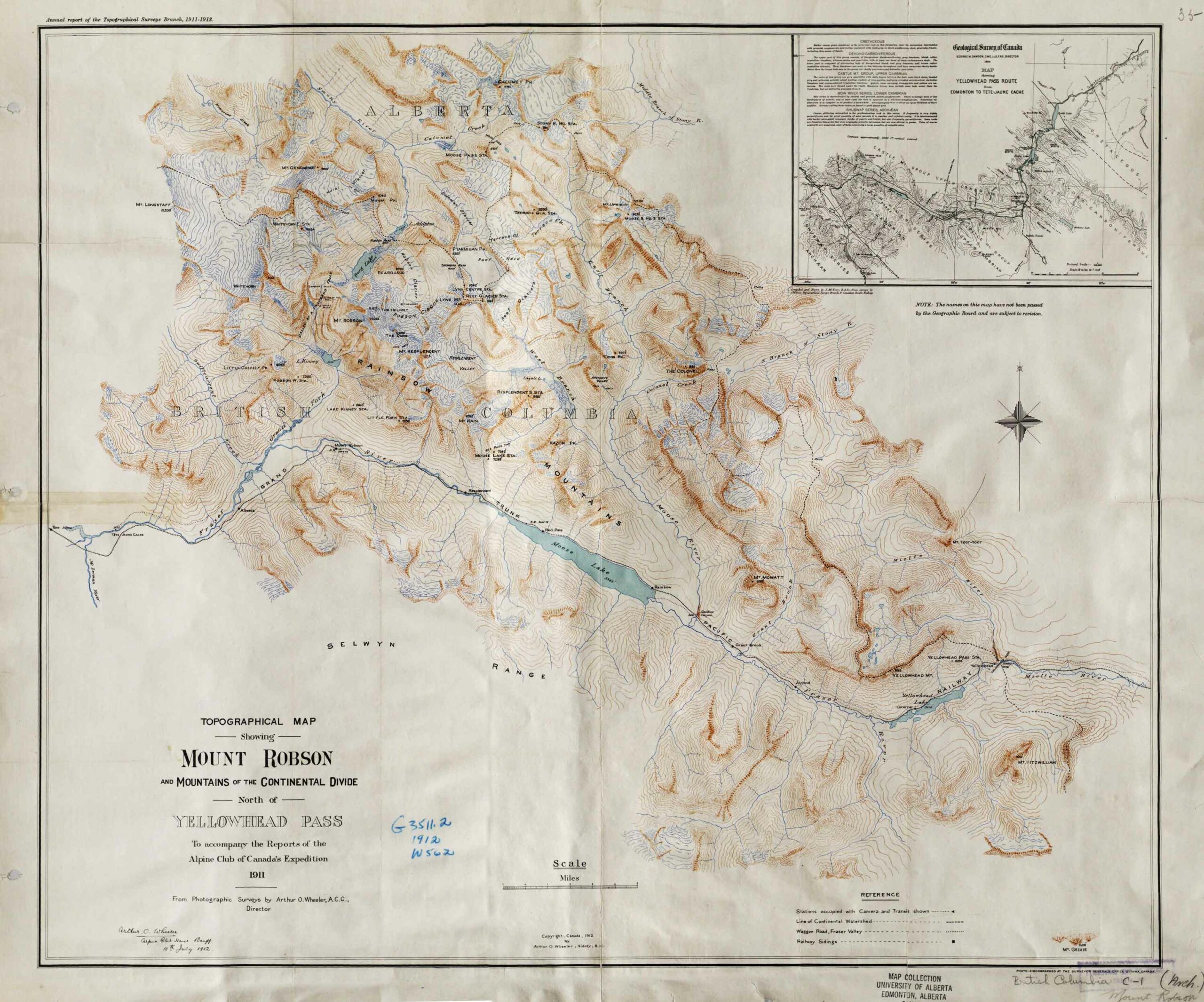
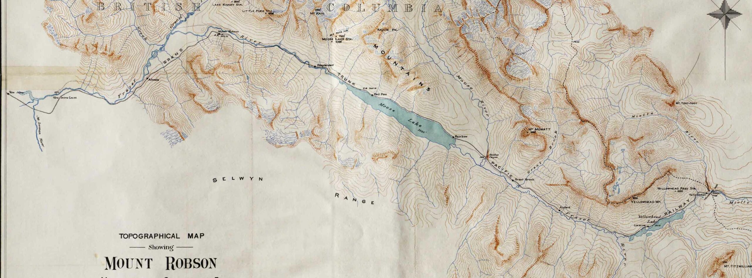
The editor of the journal, William Kaye Lamb [1904–1999], noted that Franchère’s Rocky Mountain Fort was built in 1813 on the shore of Brûlé Lake by François Decoigne [1767–1861], a clerk in the North West Company. This post later became known as Jasper House. Decoigne had been a clerk in the NWC since 1798.

The Geographic Board of the Department of the Interior published Place-names of Alberta in 1928. They claimed that the Decoigne station on the Canadian National Railway at Yellowhead Pass was named after François Decoigne, “yellow-haired trapper, after whom the Yellowhead Pass is named.”

Bohi remarks that Decoigne was previously known as Mount Cavell and Geikie.

References:

  • Franchère, Gabriel [1786–1863], and Lamb, William Kaye [1904–1999], editor. Journal of a Voyage to the Northwest Coast of America, in the years 1811, 1812, 1813, and 1814. Toronto: Champlain Society, 1969. Internet Archive
  • Bohi, Charles W., and Kozma, Leslie S. Canadian National’s Western Stations. Don Mills, Ontario: Fitzhenry & Whiteside, 2002, p. 69
  • Dictionary of Canadian Biography. Dictionary of Canadian Biography. Toronto: University of Toronto Press, 1982, François Decoigne. University of Toronto
Also see:

Mile 29

British Columbia. Railway point
About a mile west of Red Pass
Earliest known reference to this name is 1913
Not currently an official name.
Police Barracks at Mile 29. Alan K. Bourchier, 1911 (Item 2009.5.3.48)

Police Barracks at Mile 29. Alan K. Bourchier, 1911 (Item 2009.5.3.48)
Northern British Columbia Archives

Grand Trunk Pacific map [ca. 1912]


[968]

Early Grand Trunk Pacific Railway map (above) cropped and orientated to show the original stations between McBride and Jasper, which were built between 1912 and 1914.

There are only 17 stations shown between Prince George and McBride on this original plan. Missing is Legrand, which was added in 1914 during construction, to make up the original 18 stations built on that stretch. Knole station became Rider sometime after 1916, so this map seems to be from between 1912 and 1916. Rooney station was renamed Goat River (railway point) sometime between 1918 and 1923.

The rail line between Prince George and McBride was often referred to as the “East Line.” The only access from McBride to the communities west of McBride was by rail.

William Pittman Hinton, general manager of the railway’s western lines, asked Josiah Clement Wedgwood, of the Wedgwood china family, to submit a list of names suitable for naming the stations on the new railway line. Many station names on the Grand Trunk Pacific Railway have a connection to England [excerpt taken from Penny for your thoughts].

References:

  • Penny Reunion Committee 1995. A Penny for Your Thoughts. Prince George: 1995
  • Olson, Raymond W. From Liaboe to Loos and Beyond. Prince George, B.C.: Raymond W. Olson, 2011
  • Olson, Raymond W. Ghost Towns on the East Line. Prince George, B.C.: Raymond W. Olson, 2017

Mahood Lake

British Columbia. Lake: North Thompson River drainage
SW side of Wells Gray Provincial Park
51.9306 N 120.3819 W — Map 092P16 — GoogleGeoHack
Name officially adopted in 1955
Official in BCCanada

James Adams Mahood [d. 1901] conducted a Canadian Pacific Railway survey party along the shore of the lake in 1872.

EXPLORER’S DEATH
Funeral of Surveyor J. A. Mahood Takes Place Today, The funeral of J. A. Mahood is taking place this afternoon from the residence of his sister, Mrs. Berkley, Burdett avenue, and from Christ Church cathedral

The deceased was a native of St. Andrew’s, N. B., and has been engaged during the greater part of his active life with exploring parties. He served with the surveying party which prospected the proposed line across the continent from the Atlantic to the Pacific, thence up the coast to Alaska, across Behring Straits and through Siberia to the various parts of Europe. The scheme was never put into practical form.

Mr. Mahood served as major in the surveying party which had the Siberian portion of the survey to make. Upon the abandonment of this work Mr. Mahood returned to America and was engaged for a time in making surveys for the forts of San Francisco bay.

in 1872 he came to British Columbia and followed his profession in the survey works of the province.

Victoria Times, 1901-02-25, Page 3

By 1892, Mahood had cut a trail past Indianpoint Lake on his way to Tête Jaune Cache, where he was to meet the Thompson River party of Alfred Richard Cecil Selwyn [1824–1902]. A few months later the CPR chose a route far to the south and the trail fell into disuse.

References:

  • Wright, Richard. “Tales of a trail [Goat River].” BC Outdoors, (1985)
Also see:

Arthur Wheeler’s map of the Mount Robson region 1912

Topographical Map Showing Mount Robson and Mountains of the Continental Divide North of Yellowhead Pass. Arthur O. Wheeler, 1912

Topographical Map Showing Mount Robson and Mountains of the Continental Divide North of Yellowhead Pass. Arthur O. Wheeler, 1912
Victoria Library, University of Toronto


Detail showing stations on the Grand Trunk Pacific Railway.

Detail showing stations on the Grand Trunk Pacific Railway.
Victoria Library, University of Toronto

Topographical Map Showing Mount Robson and Mountains of the Continental Divide North of Yellowhead Pass
To accompany the Reports of the Alpine Club of Canada’s Expedition, 1911
From Photographic Surveys by Arthur Oliver Wheeler [1860–1945], A.C.C., Director
Annual report of the Topographical Surveys Branch, 1911-1912

With an inset showing a detail of the Geological Survey of Canada’s 1900 map of the Yellowhead Pass Route by James McEvoy [1862–1935] .

References:

  • Wheeler, Arthur Oliver [1860–1945]. “The Mountains of the Yellowhead Pass.” Alpine Journal, Vol. 26, No.198 (1912):382
  • Wheeler, Arthur Oliver [1860–1945]. “The Alpine Club of Canada’s expedition to Jasper Park, Yellowhead Pass and Mount Robson region, 1911.” Canadian Alpine Journal, Vol. 4 (1912):9-80

Mile 49

British Columbia. Railway point
Near Tête Jaune Cache
Not currently an official name.
Mile 49 buildings, 1913. Henningville (Mile 49), Tete Jaune area. Jowett Collection

Mile 49 buildings, 1913. Henningville (Mile 49), Tete Jaune area. Jowett Collection
Valemount & Area Museum

Tête Jaune Cache magistrate William A. Jowett noted in his diary in June, 1914: “To 49 for Henning’s surprise party on his return from being married with Bel and had a good time!”
The mileage is reckoned from Yellowhead Pass along the railway.

The construction company of Palmer Brothers & Henning were contractors on the construction of the Canadian Northern Pacific Railway, and had a siding on the Grand Trunk Pacific Railway line at Mile 49, near Tête Jaune Cache, to service their camps on the Canoe River. In the years after 1912, Henningville grew into a small hamlet with a Canadian Northern Pacific warehouse and some dozen other buildings, including the Austin Brothers store, Cox’s post office, and a pool hall. The name Henningville was rarely used, because the railroaders all called the location “49.”

References:

  • Walker, James Alexander [1887–1959]. “South fork of Fraser River, Dore River to Clearwater River. December 15, 1913.” Report of the Minister of Lands, (1914). Google Books

Yellowhead (railway point)

Alberta-BC boundary. Railway point
Canadian National Railway, at Yellowhead Pass
52.8833 N 118.4667 W — Map 83D/16 — GoogleGeoHack
Official in BCCanada
Yellowhead Pass (on the continental divide, boundary between Alberta and British Columbia)
Mile 18 in Albreda Subdivision (Jasper to Blue River as of 1977)
Grand Trunk Pacific Railway station built in 1912

Among depots that were left vacant on the abandoned Grand Trunk Pacific Railway grade in 1917. Yellowhead burned down about 1918.

Bohi lists “Summit” and “Yelsum” as previous names for this station.

References:

  • Bohi, Charles W., and Kozma, Leslie S. Canadian National’s Western Stations. Don Mills, Ontario: Fitzhenry & Whiteside, 2002
Also see:

Von Zuben (railway point)

British Columbia. Railway Point
Between Charles and Valemount on Canadian National Railway
52.85 N 119.2792 W — Map 83D/14 — GoogleGeoHack
Name officially adopted in 1989
Official in BCCanada
55 miles west of the Yellowhead Pass on the Canadian National Railway
Mile 73 in Albreda Subdivision (Jasper to Blue River as of 1977)

Named for Raphael Leonard von Zuben, a Canadian National Railways purchasing agent, who assisted the railroad with exploring the Canadian Rockies.

References:

  • CN (Canadian National Railway). Transportation planning branch, Edmonton, and historical office, Montréal. 2000
  • Mike von Zuben (son). Personal correspondence. 2001
Also see:

Valemount

British Columbia. Village
On Canadian National Railway, S of Swift Creek (railway point)
52.8294 N 119.28 W — Map 083D14 — GoogleGeoHack
Name officially adopted in 1963
Official in BCCanada
56 miles west of the Yellowhead Pass on the Canadian National Railway
Mile 74 in Albreda Subdivision (Jasper to Blue River as of 1977)
Canadian Northern Railway station built in 1915
This village appears on:
Pre-emptor’s map Tête Jaune 3H 1931
Valemount Type “C” CNR station.

Valemount Type “C” CNR station.
Bohi, Canadian National’s Western Depots, p. 42

A valley in the mountains — that is how Canadian National Railroad officials saw the village when the former Canadian Northern Railway station house was moved from Swift Creek, a mile west, in 1927. Alexander Kushnir, the section foreman, was asked by the railroad to poll the local citizens concerning a name for the new location. The railroad suggested “Valemount” as an alternative to the suggestion of “Burgoyne,” commemorating Jim Burgoyne who had worked in the area for many years.

The Swift Creek post office was changed to Valemount in 1928.

References:

  • Bohi, Charles W. Canadian National’s Western Depots. The Country Stations in Western Canada. Railfare Enterprises, 1977
  • Topping, William. A checklist of British Columbia post offices. Vancouver: published by the author, 7430 Angus Drive, 1983
  • Jasper-Yellowhead Historical Society. Jasper, Alberta: Jasper-Yellowhead Historical Society. Jasper-Yellowhead Museum and Archives . Jasper-Yellowhead Museum and Archives
  • Wikipedia. Valemount